Welcome to Maamigili, a Tropical island in the Laccadive Sea, part of the majestic Indian Ocean. This guide offers a comprehensive overview of what makes Maamigili unique – from its geography and climate to its population, infrastructure, and beyond. Dive into the details:
Geography and size of Maamigili
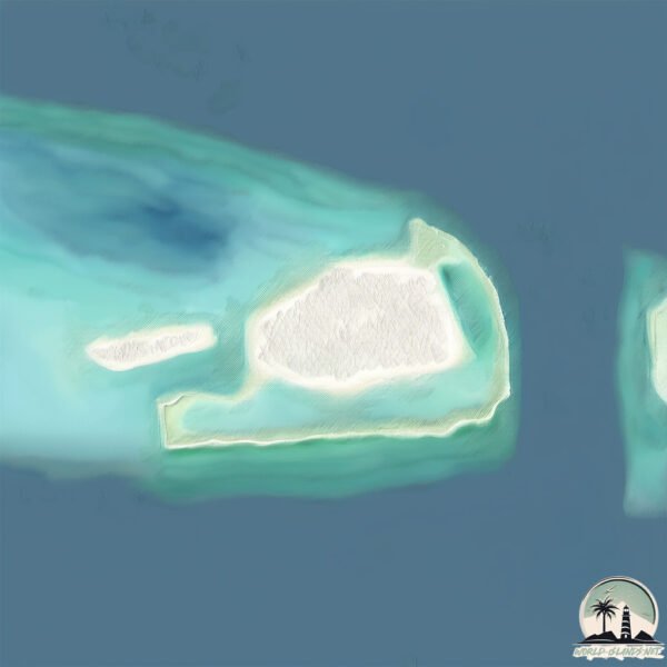
Size: 1.86 km²
Coastline: 7.9 km
Ocean: Indian Ocean
Sea: Laccadive Sea
Continent: Seven seas (open ocean)
Maamigili is a Small Island spanning 1.9 km² with a coastline of 7.9 km.
Archipel: Maldive Islands – A tropical paradise in the Indian Ocean, known for their stunning coral reefs, diverse marine life, and luxury resorts.
Tectonic Plate: Sunda – Extends across Southeast Asia, encompassing parts of the Sunda Shelf, known for its interaction with the Australian Plate, contributing to volcanic activity in Indonesia.
The geographic heart of the island is pinpointed at these coordinates:
Latitude: 3.47465377 / Longitude: 72.83663806
Climate and weather of Maamigili
Climate Zone: Tropical
Climate Details: Tropical Monsoon Climate
Temperature: Hot
Climate Characteristics: Characterized by heavy rainfall, high humidity, and uniformly high temperatures, but with a distinct short dry season. It features a seasonal reversal of prevailing wind directions.
Topography and nature of Maamigili
Timezone: UTC+05:00
Timezone places: Asia/Karachi
Max. Elevation: 2 m
Mean Elevation: -22 m
Vegetation: Urban Area
Tree Coverage: 80%
The mean elevation is -22 m. The highest elevation on the island reaches approximately 2 meters above sea level. The island is characterized by Plains: Flat, low-lying lands characterized by a maximum elevation of up to 200 meters. On islands, plains are typically coastal lowlands or central flat areas.
Dominating Vegetation: Urban Area
Regions dominated by human development, including cities and towns, characterized by buildings, roads, and minimal vegetation. Maamigili has a tree cover of 80 %.
Vegetation: 1 vegetation zones – Minimal Diversity Island
These islands exhibit the most basic level of ecological diversity, often characterized by a single dominant vegetation type. This could be due to extreme environmental conditions, limited land area, or significant human impact. They represent unique ecosystems where specific species have adapted to thrive in these singular environments.
Infrastructure and Travelling to Maamigili
Does the island have a public airport? yes.
Maamigili has a public and scheduled airport. The following airports are located on this island: Villa Airport.
Does the island have a major port? no.
There are no major ports on Maamigili. The closest major port is MALE, approximately 106 km away.
The mean population of Maamigili is 2275 per km². Maamigili is Densely Populated. The island belongs to Maldives.
Continuing your journey, Vypīn Island is the next notable island, situated merely km away.
Maamigili island
Maamigili Island, situated in the Alif Dhaal Atoll of the Maldives, is renowned for its picturesque scenery and tranquil atmosphere.Maamigili island
Maamigili Island, situated in the Alif Dhaal Atoll of the Maldives, is ...
Maamigili Island, situated in the Alif Dhaal Atoll of the Maldives, is renowned for its picturesque scenery and tranquil atmosphere.
Maamigili | My Stay at the Local Island | Island with a Potential | Maldives
Maamigili Island Tour@Thetravellingteacherjules
At the bottom of the South Ari Atoll on the feeding path of Whale ...
At the bottom of the South Ari Atoll on the feeding path of Whale Sharks, the reason for our visit. The island is about 1km x 2km it ...
Maamigili: The Whale shark Island
The Gentle Giant of Maamigili - Whale Shark in Maamigili, Maldives
One fine day in Maamigili Beru ( on the outer shore of Maamigili ...
One fine day in Maamigili Beru ( on the outer shore of Maamigili Island ). Watch how one skin-diver filmed a whale shark ...
Skydive Maldives Maamigili island IntrudAir Wingsuit P4 Pilot 7 147
Maldives Boogie Maamigili.
Maldives Boogie Maamigili.
Travel Cinematic Maldives Drone 4K Mavic Pro Maamigili Fenfushi Ariadhoo Sun Island Blue Water Ocean
Journey through the beautiful island of Maldives. Places visited: - ...
Journey through the beautiful island of Maldives. Places visited: - Ariadhoo - Maamigili - Fenfushi - Male.
馬爾地夫五星酒店渡假村體驗|Loama Resort Maldives at Maamigili
馬爾地夫居民島與水上屋渡假村的旅遊分享與紀錄,居民島體驗真正馬爾地夫人的生活,幫助當地居民復育珊瑚礁。 大家都親手種了 ...
馬爾地夫居民島與水上屋渡假村的旅遊分享與紀錄,居民島體驗真正馬爾地夫人的生活,幫助當地居民復育珊瑚礁。 大家都親手種了 ...
Maldives Boogie 2022 Intrudair P4 pilot 7 147 Landing in Maamigili island
Sun Island Resort & Spa, Maamigili, Ari Atoll, Maldives, 5 star hotel
Subscribe to the channel ...
Uncover TOP 5 Best LOCAL ISLANDS in the Maldives - Travel Guide
Join us as we uncover the top 5 best local islands in the Maldives and ...
Join us as we uncover the top 5 best local islands in the Maldives and discover why this tropical paradise should be your next ...
Go Pro Maldives Scuba diving in Rasdhoo island & Maamigili (whale shark , Manta )
這是最後幾支潛水在Rasdhoo island 還有Maamigili , 運氣很好看到whale shark & Manta ray.
這是最後幾支潛水在Rasdhoo island 還有Maamigili , 運氣很好看到whale shark & Manta ray.
MALDIVES HOLIDAY ON A BUDGET - MALE TO MAAMIGILI ISLAND #travel #maldives #male #travelwithme
Travel with me on a fabulous Maldives holiday on a budget to a local ...
Travel with me on a fabulous Maldives holiday on a budget to a local island - lots of photos info - and a total travel cost for two ...
Hidden Paradise: Maamigili Island Beach, Maldives #Maldives #Maamigili #BeachVibes #TropicalParadise
Experience the hidden paradise of Maamigili Island Beach in the ...
Experience the hidden paradise of Maamigili Island Beach in the Maldives! This breathtaking beach offers crystal-clear waters, ...
Maamigili Island, Maldives | Munnaaru 🪄🍃♥️ #shorts #shortsvideo #maldives #tropic #islandliving
Fun Trip To Maamigili | Shopping | Maldives Island 🏝
Day outing | Maamigili Island 🏝| Maldives 🇲🇻
Hellooo, It's been a while again that I couldn't upload videos but ...
Hellooo, It's been a while again that I couldn't upload videos but here you go watch out the fun vlogs… Thank you all for ...
Maamigili Island, Maldives - Feb 2019
Maldives Diving at Maamigili Island Huelhi & Manta Point
Diving in February 2019.
Diving in February 2019.
Maamigili island and "Koimala Hotels & Inns" - Walking around the island - Гуляем по острову
Maamigili island and "Koimala Hotels & Inns" dec 2021- jan 2022 ...
Maamigili island and "Koimala Hotels & Inns" dec 2021- jan 2022 Walking around the island Гуляем по острову, смотрим, что ...
Maamigili Maldives 🏝️ | Hidden Paradise Uncovered by The Travel Globe
Welcome to Maamigili – Maldives' Hidden Paradise | The Travel Globe ...
Welcome to Maamigili – Maldives' Hidden Paradise | The Travel Globe Exclusive Join The Travel Globe on a breathtaking journey ...
Tornados @Maamigili
Tornado @Maamigili.
Tornado @Maamigili.
Maamigili Island 🏝 | 1st Booster 😇 | Maldives 🇲🇻
nawiagivlogs.
nawiagivlogs.
MALDIVES - LOCAL ISLAND HOMESTAY ON MAAMIGILI #travel #maldives #maldivesislands
MALDIVES HOLIDAY ON A BUDGET - We were looking for a relaxing and ...
MALDIVES HOLIDAY ON A BUDGET - We were looking for a relaxing and laid-back and idyllic beach holiday. We didn't really ...
Maldives is classified as Developing region: Regions characterized by lower income levels, with economies in the process of industrialization and modernization. The level of income is Upper middle income.
News – Latest Updates and Headlines from Maamigili
Stay informed with the most recent news and important headlines from Maamigili. Here’s a roundup of the latest developments.
Loading...
Please note: The data used here has been primarily extracted from satellite readings. Deviations from exact values may occur, particularly regarding the height of elevations and population density. Land area and coastline measurements refer to average values at mean high tide.