Magdalen
Welcome to Magdalen, a Continental island in the Gulf of St. Lawrence, part of the majestic Atlantic Ocean. This guide offers a comprehensive overview of what makes Magdalen unique – from its geography and climate to its population, infrastructure, and beyond. Dive into the details:
- Geography and Size: Explore the island’s size and location.
- Climate and Weather: Weather patterns and temperature.
- Topography and Nature: Uncover the natural wonders of the island.
- Infrastructure and Travelling: Insights on reaching, staying, and making the most of your visit.
- News and Headlines: Latest News.
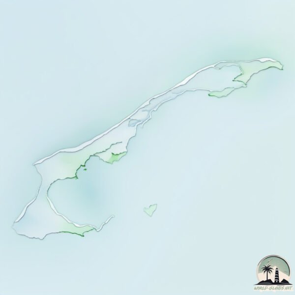
Geography and size of Magdalen
Size: 194.5 km²
Coastline: 272 km
Ocean: Atlantic Ocean
Sea: Gulf of St. Lawrence
Continent: North America
Magdalen is a Large Island spanning 195 km² with a coastline of 272 km.
Archipel: –
Tectonic Plate: North America – Covers North America and parts of the Atlantic and Arctic Oceans, characterized by diverse geological features and varying levels of seismic activity.
The geographic heart of the island is pinpointed at these coordinates:
Latitude: 47.38311568 / Longitude: -61.81445049
Climate and weather of Magdalen
Climate Zone: Continental
Climate Details: Warm-Summer Humid Continental Climate
Temperature: Warm Summer
Climate Characteristics: Features warm summers and cold winters with consistent precipitation, common in higher latitudes.
Topography and nature of Magdalen
Timezone: UTC-05:00
Timezone places: America/New_York
Max. Elevation: 110 m
Mean Elevation: 14 m
Vegetation: Agricultural Mosaic
Tree Coverage: 77%
The mean elevation is 14 m. The highest elevation on the island reaches approximately 110 meters above sea level. The island is characterized by Plains: Flat, low-lying lands characterized by a maximum elevation of up to 200 meters. On islands, plains are typically coastal lowlands or central flat areas.
Dominating Vegetation: Agricultural Mosaic
A mix of cropland and natural vegetation, often seen in rural landscapes where agricultural fields are interspersed with patches of natural habitats. Magdalen has a tree cover of 77 %.
Vegetation: 14 vegetation zones – Exceptionally Diverse Island
Islands with more than ten vegetation zones are among the most ecologically rich and varied in the world. These islands are akin to miniature continents, boasting an incredible array of ecosystems. The sheer range of habitats, from high peaks to deep valleys, rainforests to deserts, creates a mosaic of life that is unparalleled. They are crucial for conservation and ecological studies.
Infrastructure and Travelling to Magdalen
Does the island have a public airport? no.
There is no public and scheduled airport on Magdalen. The nearest airport is Îles-de-la-Madeleine Airport, located 4 km away.
Does the island have a major port? no.
There are no major ports on Magdalen. The closest major port is GEORGETOWN, approximately 129 km away.
The mean population of Magdalen is 54 per km². Magdalen is Gently Populated. The island belongs to Canada.
Continuing your journey, Île du Havre aux Maisons is the next notable island, situated merely km away.
Magdalen Islands: Unveiling the Enchanting Secrets of Quebec's Coastal Gem


Canada is classified as Developed region: G7: Group of Seven – Major advanced economies, including Canada, France, Germany, Italy, Japan, the United Kingdom, and the United States. The level of income is High income: OECD.
News – Latest Updates and Headlines from Magdalen
Stay informed with the most recent news and important headlines from Magdalen. Here’s a roundup of the latest developments.
Please note: The data used here has been primarily extracted from satellite readings. Deviations from exact values may occur, particularly regarding the height of elevations and population density. Land area and coastline measurements refer to average values at mean high tide.