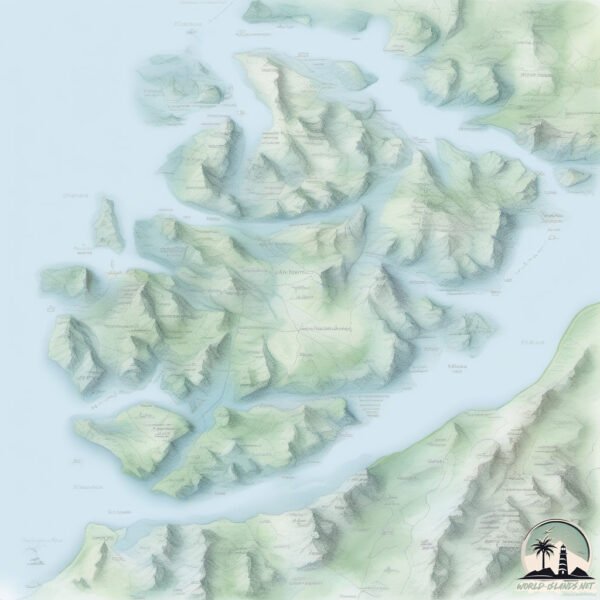
Welcome to Magdalena, a Dry island in the North Pacific Ocean, part of the majestic Pacific Ocean. This guide offers a comprehensive overview of what makes Magdalena unique – from its geography and climate to its population, infrastructure, and beyond. Dive into the details:
Geography and size of Magdalena
Size: 291.4 km²
Coastline: 296.6 km
Ocean: Pacific Ocean
Sea: North Pacific Ocean
Continent: North America
Magdalena is a Large Island spanning 291 km² with a coastline of 297 km.
Archipel: –
Tectonic Plate: Pacific – The world’s largest tectonic plate, covering much of the Pacific Ocean, known for the Pacific Ring of Fire with extensive seismic and volcanic activity.
The geographic heart of the island is pinpointed at these coordinates:
Latitude: 24.88401404 / Longitude: -112.19171118
Climate and weather of Magdalena
Climate Zone: Dry
Climate Details: Hot Deserts Climate
Temperature: Hot
Climate Characteristics: Dominated by extremely hot temperatures, this climate is marked by minimal rainfall and barren landscapes. Nights often experience drastic temperature drops.
Topography and nature of Magdalena
Timezone: UTC-07:00
Timezone places: America/Denver
Max. Elevation: 247 m
Mean Elevation: 12 m
Vegetation: Sandy Terrain
Tree Coverage: 22%
The mean elevation is 12 m. The highest elevation on the island reaches approximately 247 meters above sea level. The island is characterized by Hills: Gently sloping landforms with rounded tops, having a maximum elevation between 200 and 500 meters. Hills contribute to a varied landscape on islands.
Dominating Vegetation: Sandy Terrain
Areas covered primarily with sand, like dunes and beaches, where vegetation is sparse due to the dry and shifting substrate. Magdalena has a tree cover of 22 %.
Vegetation: 15 vegetation zones – Exceptionally Diverse Island
Islands with more than ten vegetation zones are among the most ecologically rich and varied in the world. These islands are akin to miniature continents, boasting an incredible array of ecosystems. The sheer range of habitats, from high peaks to deep valleys, rainforests to deserts, creates a mosaic of life that is unparalleled. They are crucial for conservation and ecological studies.
Infrastructure and Travelling to Magdalena
Does the island have a public airport? no.
There is no public and scheduled airport on Magdalena. The nearest airport is Ciudad Constitución National Airport, located 59 km away.
Does the island have a major port? no.
There are no major ports on Magdalena. The closest major port is SAN JUAN DE LA COSTA, approximately 152 km away.
The mean population of Magdalena is 1 per km². Magdalena is Uninhabited. The island belongs to Mexico.
Continuing your journey, Santo Domingo is the next notable island, situated merely km away.
Walking with Penguins on Magdalena Island in Chile (Travel Video Blog 50)
60.000 penguins are living on a small island near Punta Arenas in Chile. Walking with penguins on Magdalena Island in Chile is ...Walking with Penguins on Magdalena Island in Chile (Travel Video Blog 50)
60.000 penguins are living on a small island near Punta Arenas in ...
60.000 penguins are living on a small island near Punta Arenas in Chile. Walking with penguins on Magdalena Island in Chile is ...
Magdalena Island | Getaway 2020
The declared Natural Monument is home to one of Chile's largest ...
The declared Natural Monument is home to one of Chile's largest penguin colonies and the best rookery in Patagonia for tourists ...
video, Punta Arenas, Isla Magdalena, cruises around the world, Captain Cruise online, Nicko cruises
Laat je inspireren voor een mooie cruisevakantie kijk nu op de website ...
Laat je inspireren voor een mooie cruisevakantie kijk nu op de website ...
Meet the Penguins of Magdalena Island, Chile
Enjoy a quick 30 second visit to the largest penguin colony in Chile, ...
Enjoy a quick 30 second visit to the largest penguin colony in Chile, located on Magdalena Island, a tiny island just off the ...
Magellanic Penguin on Magdalena Island Chile
(Dec 2012) Magellanic Penguin on Magdalena Island One of Chile's ...
(Dec 2012) Magellanic Penguin on Magdalena Island One of Chile's largest and most important Magellanic penguin breeding ...
MAGDALENA ISLAND'S MAGELLANIC PENGUINS, NEAR PUNTA ARENAS, CHILE
Magdalena Island (in Spanish, it is Isla Magdalena) is a small island ...
Magdalena Island (in Spanish, it is Isla Magdalena) is a small island in the Strait of Magellan, Chile. It is located in Magallanes ...
Magdalena Island, Chile
On our trip to Patagonia, we took a boat over to Magdalena Island to ...
On our trip to Patagonia, we took a boat over to Magdalena Island to see the penguins.
Magdalena Island | Getaway 2020
Penguins of Magdalena Island, Punta Arenas, Chile
While in Chile we took a ferry from Punta Arenas to Isla Magalena in ...
While in Chile we took a ferry from Punta Arenas to Isla Magalena in the Strait of Magellan to spend an hour walking around the ...
Penguins - Magdalena Island, Chile
Travel - Chile - Penguins.
Travel - Chile - Penguins.
Magellanic Penguins Draw Crowds To Chile’s Magdalena Island At Los Pingüinos Natural Monument
Thousands of Magellanic penguins are once again drawing visitors to ...
Thousands of Magellanic penguins are once again drawing visitors to Magdalena Island in Chilean Patagonia, where the ...
Penguins on Magdalena Island
Los Pingüinos Natural Monument Nov 29th 2018 Punta Arenas, Magallanes ...
Los Pingüinos Natural Monument Nov 29th 2018 Punta Arenas, Magallanes and Chilean Antarctica, Chile Lucky for you, they can ...
🐧Magdalena Island: 120K Penguins & Brutal Winds!❄️ #adventuretravel #traveltips #bucketlisttravel
Magdalena Island – 120000 Penguins & Extreme Winds! ❄️ Magdalena ...
Magdalena Island – 120000 Penguins & Extreme Winds! ❄️ Magdalena Island, Chile – One of the largest Magellanic ...
Magdalena Island, Chile – Home of the Magellanic Penguins
Remember to Like & Subscribe --- Magdalena Island is a small island in ...
Remember to Like & Subscribe --- Magdalena Island is a small island in the Strait of Magellan, Chile, renowned for its large ...
Visiting the penguin colony on Magdalena Island
Visiting the Magellanic penguin colony on Magdalena Island on the ...
Visiting the Magellanic penguin colony on Magdalena Island on the final day of the Cape Horn Cruise.
Magdalena Island final movie
Punta Arenas, Chile, one of Chile's largest and most important ...
Punta Arenas, Chile, one of Chile's largest and most important Magellanic penguin breeding sites, situated on Magdalena Island ...
2022 Chile, Penguins Natural Monument in Magdalena Island
Magdalena Island is in the Strait of Magellan, just northeast of Punta ...
Magdalena Island is in the Strait of Magellan, just northeast of Punta Arenas. It is home to Penguins Natural Monument. Antonio ...
Magdalen Islands: Unveiling the Enchanting Secrets of Quebec's Coastal Gem
The Magdalen Islands, also known as the Îles de la Madeleine, are a ...
The Magdalen Islands, also known as the Îles de la Madeleine, are a small archipelago located in the Gulf of Saint Lawrence off ...
Magdalena Island: where monogamous penguins come to breed
50km-away from Punta Arena in southern Chile is the Magdalena Island, ...
50km-away from Punta Arena in southern Chile is the Magdalena Island, home to the Magellan penguins. This species of ...
Magellanic Penguins on Isla Magdalena in 360
Chilean Patagonia is home to Isla Magdalena which is a small island ...
Chilean Patagonia is home to Isla Magdalena which is a small island located in the Strait of Magellan. The island is home to about ...
Penguins on Magdalena Island ©Kristina Trowbridge
the last day of our cruise on the Via Australis, we landed on ...
the last day of our cruise on the Via Australis, we landed on Magdalena Island in the Strait of Magellan, not far from Punta Arenas ...
Magellen Penguin Colony on Magdalena Island
Magellen Penguin Colony on Magdalena Island, near Punto Arenas, Chile.
Magellen Penguin Colony on Magdalena Island, near Punto Arenas, Chile.
Magdalena Island Penguin Reserve - Cruise Excursion
La isla de los pingüinos is an extraordinary penguin reserve on ...
La isla de los pingüinos is an extraordinary penguin reserve on Magdalena Island in the Strait of Magellan, Chile. More than ...
Exploring Penguin Paradise: Magdalena Island, Chile 🐧🇨🇱
Welcome to Magdalena Island, Chile! Located in the heart of the Strait ...
Welcome to Magdalena Island, Chile! Located in the heart of the Strait of Magellan, Magdalena Island is a must-visit ...
Mexico is classified as Emerging region: MIKT: Mexico, Indonesia, South Korea, and Turkey – Economies recognized for their development potential and emerging market status. The level of income is Upper middle income.
News – Latest Updates and Headlines from Magdalena
Stay informed with the most recent news and important headlines from Magdalena. Here’s a roundup of the latest developments.
Loading...
Please note: The data used here has been primarily extracted from satellite readings. Deviations from exact values may occur, particularly regarding the height of elevations and population density. Land area and coastline measurements refer to average values at mean high tide.