Malabar
Welcome to Malabar, a Tropical island in the Indian Ocean, part of the majestic Indian Ocean. This guide offers a comprehensive overview of what makes Malabar unique – from its geography and climate to its population, infrastructure, and beyond. Dive into the details:
- Geography and Size: Explore the island’s size and location.
- Climate and Weather: Weather patterns and temperature.
- Topography and Nature: Uncover the natural wonders of the island.
- Infrastructure and Travelling: Insights on reaching, staying, and making the most of your visit.
- News and Headlines: Latest News.
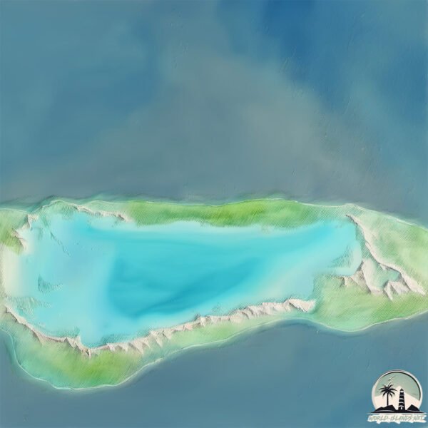
Geography and size of Malabar
Size: 25.7 km²
Coastline: 45.6 km
Ocean: Indian Ocean
Sea: Indian Ocean
Continent: Seven seas (open ocean)
Malabar is a Medium Island spanning 26 km² with a coastline of 46 km.
Archipel: Seychelles – An archipelago of 115 islands in the Indian Ocean, known for their stunning natural beauty, unique flora and fauna, and as a luxury travel destination.
Tectonic Plate: Woodlark – Situated in the eastern part of Papua New Guinea, the Woodlark Plate is a small tectonic plate primarily consisting of oceanic crust and undergoing active rifting, contributing to the complex geology of the region.
The geographic heart of the island is pinpointed at these coordinates:
Latitude: -9.37575505 / Longitude: 46.36150221
Climate and weather of Malabar
Climate Zone: Tropical
Climate Details: Tropical Savanna, Wet
Temperature: Hot
Climate Characteristics: Defined by distinct wet and dry seasons with high temperatures year-round. Pronounced rainfall occurs during the wet season, while the dry season is marked by drought.
Topography and nature of Malabar
Timezone: UTC+04:00
Timezone places: Asia/Dubai
Max. Elevation: 8 m
Mean Elevation: -5 m
Vegetation: Evergreen Broadleaf Forest
Tree Coverage: 59%
The mean elevation is -5 m. The highest elevation on the island reaches approximately 8 meters above sea level. The island is characterized by Plains: Flat, low-lying lands characterized by a maximum elevation of up to 200 meters. On islands, plains are typically coastal lowlands or central flat areas.
Dominating Vegetation: Evergreen Broadleaf Forest
Characterized by dense, lush canopies of broadleaf trees that retain their leaves year-round. These forests are typically found in tropical and subtropical regions and are known for their high biodiversity. Malabar has a tree cover of 59 %.
Vegetation: 6 vegetation zones – Very Highly Diverse Island
Islands in this range are ecological powerhouses, showcasing a wide array of vegetation zones. Each zone, from lush rainforests to arid scrublands, coastal mangroves to mountainous regions, contributes to a complex and interdependent ecosystem. These islands are often hotspots of biodiversity, supporting numerous species and intricate ecological processes.
Infrastructure and Travelling to Malabar
Does the island have a public airport? no.
There is no public and scheduled airport on Malabar. The nearest airport is Ouani Airport, located 368 km away.
Does the island have a major port? no.
There are no major ports on Malabar. The closest major port is MOUTSAMOUDU, approximately 372 km away.
The mean population of Malabar is 4 per km². Malabar is Gently Populated. The island belongs to Seychelles.
The name of the island resonates across different cultures and languages. Here is how it is known around the world: Arabic: ألدبرا; German: Aldabra; Spanish: Isla Aldabra; French: Aldabra; Portuguese: Ilha Aldabra; Russian: остров Альдабра; Chinese: 阿尔达不拉岛
Continuing your journey, Aldabra is the next notable island, situated merely km away.
Malabar Circuit, Lord Howe Island, NSW


Seychelles is classified as Developing region: Regions characterized by lower income levels, with economies in the process of industrialization and modernization. The level of income is Upper middle income.
News – Latest Updates and Headlines from Malabar
Stay informed with the most recent news and important headlines from Malabar. Here’s a roundup of the latest developments.
Please note: The data used here has been primarily extracted from satellite readings. Deviations from exact values may occur, particularly regarding the height of elevations and population density. Land area and coastline measurements refer to average values at mean high tide.