Welcome to Malabrigo, a Tropical island in the South Pacific Ocean, part of the majestic Pacific Ocean. This guide offers a comprehensive overview of what makes Malabrigo unique – from its geography and climate to its population, infrastructure, and beyond. Dive into the details:
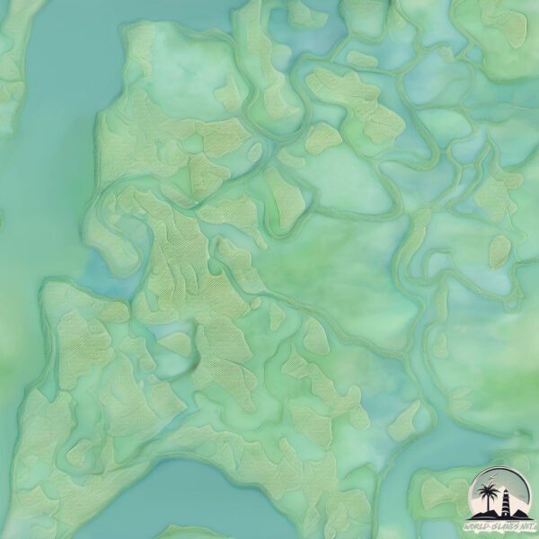
Geography and size of Malabrigo
Size: 19.9 km²
Coastline: 26.7 km
Ocean: Pacific Ocean
Sea: South Pacific Ocean
Continent: South America
Malabrigo is a Medium Island spanning 20 km² with a coastline of 27 km.
Archipel: –
Tectonic Plate: Nazca – An oceanic tectonic plate off the west coast of South America. Famous for the Nazca Lines, it’s primarily known for its subduction under the South American Plate, leading to the Andes Mountains’ formation and significant seismic activity.
The geographic heart of the island is pinpointed at these coordinates:
Latitude: -2.42381571 / Longitude: -79.96644529
Climate and weather of Malabrigo
Climate Zone: Tropical
Climate Details: Tropical Savanna, Wet
Temperature: Hot
Climate Characteristics: Defined by distinct wet and dry seasons with high temperatures year-round. Pronounced rainfall occurs during the wet season, while the dry season is marked by drought.
Topography and nature of Malabrigo
Timezone: UTC-05:00
Timezone places: America/New_York
Max. Elevation: 10 m
Mean Elevation: 5 m
Vegetation: Mangrove Forest
Tree Coverage: 83%
The mean elevation is 5 m. The highest elevation on the island reaches approximately 10 meters above sea level. The island is characterized by Plains: Flat, low-lying lands characterized by a maximum elevation of up to 200 meters. On islands, plains are typically coastal lowlands or central flat areas.
Dominating Vegetation: Mangrove Forest
Found in coastal areas and river deltas, these unique wetland ecosystems are adapted to saline conditions and are crucial for coastal protection and biodiversity. Malabrigo has a tree cover of 83 %.
Vegetation: 6 vegetation zones – Very Highly Diverse Island
Islands in this range are ecological powerhouses, showcasing a wide array of vegetation zones. Each zone, from lush rainforests to arid scrublands, coastal mangroves to mountainous regions, contributes to a complex and interdependent ecosystem. These islands are often hotspots of biodiversity, supporting numerous species and intricate ecological processes.
Infrastructure and Travelling to Malabrigo
Does the island have a public airport? no.
There is no public and scheduled airport on Malabrigo. The nearest airport is José Joaquín de Olmedo International Airport, located 29 km away.
Does the island have a major port? no.
There are no major ports on Malabrigo. The closest major port is PUERTO MARITIMO DE GUAYAQUIL, approximately 15 km away.
The mean population of Malabrigo is 1303 per km². Malabrigo is Densely Populated. The island belongs to Ecuador.
Continuing your journey, San Agnacio is the next notable island, situated merely km away.
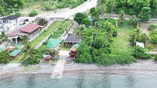
MALABRIGO LIGHT HOUSE AND BEACH RESORT | WHERE TO FIND YOUR NEW RELAXING PLACE?
Malabrigo Lighthouse and Beach Resort was located in the southern part of Lobo, Batangas. Faro de Punta Malabrigo, also ...MALABRIGO LIGHT HOUSE AND BEACH RESORT | WHERE TO FIND YOUR NEW RELAXING PLACE?
Malabrigo Lighthouse and Beach Resort was located in the southern part ...
Malabrigo Lighthouse and Beach Resort was located in the southern part of Lobo, Batangas. Faro de Punta Malabrigo, also ...
Verde Island and Malabrigo (Lobo), Batangas (Aerials Views in 4K)
KEY PLACES FEATURED ON THIS VIDEO: - Isla Verde Lighthouse (Verde ...
KEY PLACES FEATURED ON THIS VIDEO: - Isla Verde Lighthouse (Verde Island, Batangas) - Kweba San Andres Isla Verde ...
De Marvic Beach Resort | Lobo Batangas | Malabrigo Lighthouse Side Trip
You may also contact them directly at this number: 09186708078 ...
You may also contact them directly at this number: 09186708078 ====================================== With side trip ...
Malabrigo Beach - Lobo , Batangas
Unlike popular tourist destinations such as Laiya, Pico de Loro, ...
Unlike popular tourist destinations such as Laiya, Pico de Loro, Nasugbu, and Puerto Galera, this pebble-covered beach stayed ...
Malabrigo Beach - Lobo, Batangas (Philippines)
My birthday weekend was so much fun! It was my first time here.. ♢ M U ...
My birthday weekend was so much fun! It was my first time here.. ♢ M U S I C ♢ → The Ocean - Mike Perry feat. Shy martin I'm ......[+] Show More TFR series 4;Malabrigo Lobo batangas Beach resort
One of the hidden paradise of the Province of Batangas,great to spend ...
One of the hidden paradise of the Province of Batangas,great to spend your weekend getaway with friends and love ones.
Punta Malabrigo Beach Resort, Lobo Batangas ( MDespino TV vlog)
Perfect place to relax and recharge... come visit Punta Malabrigo ...
Perfect place to relax and recharge... come visit Punta Malabrigo Beach Resort, Brgy. Malabrigo Lobo Batangas.. A mixed of Sand ...
A Short Tour in Malabrigo Lobo Batangas Feat. Faro de Punta de Malabrigo #lighthouse #beach
This is a short tour experience in Brgy Malabrigo Lobo Batangas where ...
This is a short tour experience in Brgy Malabrigo Lobo Batangas where my dad was born and raise. join me on my journey and ...
Punta Malabrigo Beach Lobo Batangas
Summer get a way experience w/ my Trese fam.
Summer get a way experience w/ my Trese fam.
MALABRIGO LOBO BATANGAS 🏖️
Malabrigo, Batangas | Paradise you need to explore! - 4K Drone Film
Malabrigo, Lobo Batangas - 4K Drone Film La Bien Beach Resort.
Malabrigo, Lobo Batangas - 4K Drone Film La Bien Beach Resort.
A Trip to Malabrigo
Not your typical white beach... The pebble beach of Malabrigo! With ...
Not your typical white beach... The pebble beach of Malabrigo! With sidetrip to Malabrigo Lighthouse.
Affordable beach campsite in Malabrigo, Lobo Batangas #beachcamping
Yung biglaan talaga ang natutuloy La Cueva Camping site - Malabrigo ...
Yung biglaan talaga ang natutuloy La Cueva Camping site - Malabrigo lobo, Batangas Beach camping site in Malabrigo, Lobo ...
Beach Mode at Malabrigo Lobo Batangas #shorts #fyp
Malabrigo, Lobo, Batangas
Relaxing beaches, wonderful views of nature, plenty of resorts along ...
Relaxing beaches, wonderful views of nature, plenty of resorts along the beach.
Malabrigo Lighthouse | Lobo, Batangas | Cinematic View #8.
CinematicView #HondaXAdvClubPhInc #MalabrigoLighthouse Malabrigo Point ...
CinematicView #HondaXAdvClubPhInc #MalabrigoLighthouse Malabrigo Point Lighthouse, also known as Faro de Punta ...
PUNTA MALABRIGO, LOBO BATANGAS
SANZ Summer of 2019 Drone/Aerial shots courtesy of Andrew Brizuela, ...
SANZ Summer of 2019 Drone/Aerial shots courtesy of Andrew Brizuela, SLO MO Shots by EJ Damian. With Special Participation ...
Malabrigo Beach Camp | Beautiful sunset | Lobo Batangas
It is one of our many favorite spot to visit and enjoy. Lobo Batangas ...
It is one of our many favorite spot to visit and enjoy. Lobo Batangas is simply amazing when it comes to location, people and sea ...
Malabrigo Lighthouse, Malabrigo, Lobo, Batangas aerial shot.
quick aerial shot of Malabrigo Lighthouse and my ever reliable iron ...
quick aerial shot of Malabrigo Lighthouse and my ever reliable iron steed, Royal Enfield Himalayan. Thank you Mayor and ...
Malabrigo Lobo, Batangas #philippines #shorts #batangas
LAST PART PUNTA MALABRIGO BEACH WITH KATUWAAN
LAST PART PUNTA MALABRIGO BEACH WITH KATUWAAN Hope you like this ...
LAST PART PUNTA MALABRIGO BEACH WITH KATUWAAN Hope you like this video,Thank you for watching. Please support my ...
#travel #malabrigo lobo batangas
Punta Malabrigo Beach Resort & Malabrigo Lighthouse
Ride to Punta Malabrigo Beach Resort in Lobo, Batangas. You can ...
Ride to Punta Malabrigo Beach Resort in Lobo, Batangas. You can message them on FB if you have questions: ...
MALABRIGO LOBO BATANGAS 1 #benangelmhitzmacabidang #beach #travel #foryou
benangelmhitzmacabidang #beach #malabrigo #lobobatangas #trave #fun ...
benangelmhitzmacabidang #beach #malabrigo #lobobatangas #trave #fun #enjoy #foryou #subscribers #followers #yt.
Ecuador is classified as Developing region: Regions characterized by lower income levels, with economies in the process of industrialization and modernization. The level of income is Upper middle income.
News – Latest Updates and Headlines from Malabrigo
Stay informed with the most recent news and important headlines from Malabrigo. Here’s a roundup of the latest developments.
Loading...
Please note: The data used here has been primarily extracted from satellite readings. Deviations from exact values may occur, particularly regarding the height of elevations and population density. Land area and coastline measurements refer to average values at mean high tide.