Malaita
Welcome to Malaita, a Tropical island in the South Pacific Ocean, part of the majestic Pacific Ocean. This guide offers a comprehensive overview of what makes Malaita unique – from its geography and climate to its population, infrastructure, and beyond. Dive into the details:
- Geography and Size: Explore the island’s size and location.
- Climate and Weather: Weather patterns and temperature.
- Topography and Nature: Uncover the natural wonders of the island.
- Infrastructure and Travelling: Insights on reaching, staying, and making the most of your visit.
- News and Headlines: Latest News.
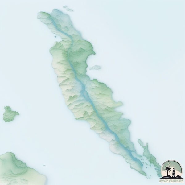
Geography and size of Malaita
Size: 3749 km²
Coastline: 704 km
Ocean: Pacific Ocean
Sea: South Pacific Ocean
Continent: Oceania
Malaita is a Very Large Island spanning 3749 km² with a coastline of 704 km.
Archipel: Melanesia – A subregion of Oceania in the southwestern Pacific Ocean, including countries like Fiji, Solomon Islands, and Vanuatu, known for their diverse cultures and languages.
Tectonic Plate: Pacific – The world’s largest tectonic plate, covering much of the Pacific Ocean, known for the Pacific Ring of Fire with extensive seismic and volcanic activity.
The geographic heart of the island is pinpointed at these coordinates:
Latitude: -8.91719292 / Longitude: 160.94738643
Climate and weather of Malaita
Climate Zone: Tropical
Climate Details: Tropical Rainforest Climate
Temperature: Hot
Climate Characteristics: This climate is typified by heavy rainfall throughout the year, high humidity, and consistently high temperatures, leading to lush rainforests and rich biodiversity. Seasonal temperature variations are minimal.
Topography and nature of Malaita
Timezone: UTC+11:00
Timezone places: Pacific/Guadalcanal
Max. Elevation: 1165 m
Mean Elevation: 280 m
Vegetation: Evergreen Broadleaf Forest
Tree Coverage: 73%
The mean elevation is 280 m. The highest elevation on the island reaches approximately 1165 meters above sea level. The island is characterized by Plateau: Elevated flatlands rising sharply above the surrounding area, with a maximum elevation over 500 meters but a mean elevation less than 300 meters, forming unique highland areas on islands.
Dominating Vegetation: Evergreen Broadleaf Forest
Characterized by dense, lush canopies of broadleaf trees that retain their leaves year-round. These forests are typically found in tropical and subtropical regions and are known for their high biodiversity. Malaita has a tree cover of 73 %.
Vegetation: 11 vegetation zones – Exceptionally Diverse Island
Islands with more than ten vegetation zones are among the most ecologically rich and varied in the world. These islands are akin to miniature continents, boasting an incredible array of ecosystems. The sheer range of habitats, from high peaks to deep valleys, rainforests to deserts, creates a mosaic of life that is unparalleled. They are crucial for conservation and ecological studies.
Infrastructure and Travelling to Malaita
Does the island have a public airport? yes.
Malaita has a public and scheduled airport. The following airports are located on this island: Afutara Aerodrome, Uru Harbour Airport, Gwaunaru’u Airport.
Does the island have a major port? no.
There are no major ports on Malaita. The closest major port is TULAGHI, approximately 69 km away.
The mean population of Malaita is 35 per km². Malaita is Gently Populated. The island belongs to Solomon Islands.
The name of the island resonates across different cultures and languages. Here is how it is known around the world: Arabic: ماليتا; German: Malaita; Spanish: Malaita; French: Malaita; Portuguese: Malaita; Russian: Малаита; Chinese: 馬萊塔島
Continuing your journey, Manaoba is the next notable island, situated merely km away.
I Spent 2 Days in the Highlands of Malaita 🇸🇧


Solomon Islands is classified as Least developed region: Countries that exhibit the lowest indicators of socioeconomic development, with the lowest Human Development Index ratings. The level of income is Lower middle income.
News – Latest Updates and Headlines from Malaita
Stay informed with the most recent news and important headlines from Malaita. Here’s a roundup of the latest developments.
Social Media Posts about Malaita
Please note: The data used here has been primarily extracted from satellite readings. Deviations from exact values may occur, particularly regarding the height of elevations and population density. Land area and coastline measurements refer to average values at mean high tide.