Manamoc
Welcome to Manamoc, a Tropical island in the Sulu Sea, part of the majestic Pacific Ocean. This guide offers a comprehensive overview of what makes Manamoc unique – from its geography and climate to its population, infrastructure, and beyond. Dive into the details:
- Geography and Size: Explore the island’s size and location.
- Climate and Weather: Weather patterns and temperature.
- Topography and Nature: Uncover the natural wonders of the island.
- Infrastructure and Travelling: Insights on reaching, staying, and making the most of your visit.
- News and Headlines: Latest News.
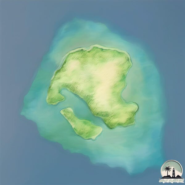
Geography and size of Manamoc
Size: 5.958 km²
Coastline: 16.2 km
Ocean: Pacific Ocean
Sea: Sulu Sea
Continent: Asia
Manamoc is a Small Island spanning 6 km² with a coastline of 16.2 km.
Archipel: Philippines – An archipelago of over 7,000 islands in Southeast Asia, known for their diverse cultures, languages, stunning landscapes, and rich biodiversity.
Tectonic Plate: Sunda – Extends across Southeast Asia, encompassing parts of the Sunda Shelf, known for its interaction with the Australian Plate, contributing to volcanic activity in Indonesia.
The geographic heart of the island is pinpointed at these coordinates:
Latitude: 11.30829045 / Longitude: 120.68595161
Climate and weather of Manamoc
Climate Zone: Tropical
Climate Details: Tropical Monsoon Climate
Temperature: Hot
Climate Characteristics: Characterized by heavy rainfall, high humidity, and uniformly high temperatures, but with a distinct short dry season. It features a seasonal reversal of prevailing wind directions.
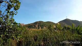
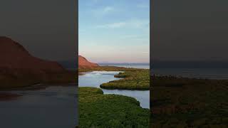
Topography and nature of Manamoc
Timezone: UTC+08:00
Timezone places: Australia/Perth
Max. Elevation: 73 m
Mean Elevation: 34 m
Vegetation: Open Woodland
Tree Coverage: 48%
The mean elevation is 34 m. The highest elevation on the island reaches approximately 73 meters above sea level. The island is characterized by Plains: Flat, low-lying lands characterized by a maximum elevation of up to 200 meters. On islands, plains are typically coastal lowlands or central flat areas.
Dominating Vegetation: Open Woodland
Characterized by sparsely distributed trees with open canopy allowing sunlight to penetrate, supporting grasses and shrubs underneath. Often found in drier or transitional environments. Manamoc has a tree cover of 48 %.
Vegetation: 8 vegetation zones – Very Highly Diverse Island
Islands in this range are ecological powerhouses, showcasing a wide array of vegetation zones. Each zone, from lush rainforests to arid scrublands, coastal mangroves to mountainous regions, contributes to a complex and interdependent ecosystem. These islands are often hotspots of biodiversity, supporting numerous species and intricate ecological processes.
Infrastructure and Travelling to Manamoc
Does the island have a public airport? no.
There is no public and scheduled airport on Manamoc. The nearest airport is Cuyo Airport, located 64 km away.
Does the island have a major port? no.
There are no major ports on Manamoc. The closest major port is ILOILO, approximately 220 km away.
The mean population of Manamoc is 456 per km². Manamoc is Moderately Inhabited. The island belongs to Philippines.
Continuing your journey, Agutaya is the next notable island, situated merely km away.
Manamoc Island: Unknown Gem beyond Amanpulo | Discover Palawan | Travel Documentary


Philippines is classified as Emerging region: G20: Group of Twenty – Major economies comprising both developed and emerging countries, representing the world’s largest economies. The level of income is Lower middle income.
News – Latest Updates and Headlines from Manamoc
Stay informed with the most recent news and important headlines from Manamoc. Here’s a roundup of the latest developments.
Please note: The data used here has been primarily extracted from satellite readings. Deviations from exact values may occur, particularly regarding the height of elevations and population density. Land area and coastline measurements refer to average values at mean high tide.