Welcome to Mandativu, a Tropical island in the Bay of Bengal, part of the majestic Indian Ocean. This guide offers a comprehensive overview of what makes Mandativu unique – from its geography and climate to its population, infrastructure, and beyond. Dive into the details:
Geography and size of Mandativu
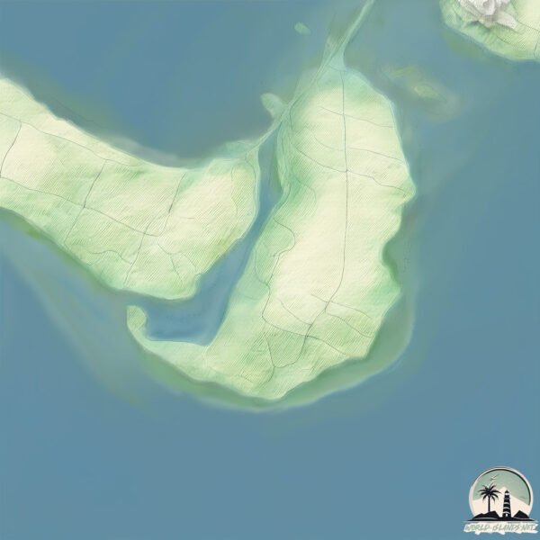
Size: 9.793 km²
Coastline: 20.6 km
Ocean: Indian Ocean
Sea: Bay of Bengal
Continent: Asia
Mandativu is a Small Island spanning 9.8 km² with a coastline of 20.6 km.
Archipel: –
Tectonic Plate: India – A major tectonic plate that initially moved northward at a rapid pace before colliding with the Eurasian Plate. This collision is responsible for the uplift of the Himalayas and the Tibetan Plateau.
The geographic heart of the island is pinpointed at these coordinates:
Latitude: 9.61524278 / Longitude: 79.99139131
Climate and weather of Mandativu
Climate Zone: Tropical
Climate Details: Tropical Savanna, Wet
Temperature: Hot
Climate Characteristics: Defined by distinct wet and dry seasons with high temperatures year-round. Pronounced rainfall occurs during the wet season, while the dry season is marked by drought.
Topography and nature of Mandativu
Timezone: UTC+05:30
Timezone places: Asia/Kolkata
Max. Elevation: 7 m
Mean Elevation: 3 m
Vegetation: Agricultural Mosaic
Tree Coverage: 40%
The mean elevation is 3 m. The highest elevation on the island reaches approximately 7 meters above sea level. The island is characterized by Plains: Flat, low-lying lands characterized by a maximum elevation of up to 200 meters. On islands, plains are typically coastal lowlands or central flat areas.
Dominating Vegetation: Agricultural Mosaic
A mix of cropland and natural vegetation, often seen in rural landscapes where agricultural fields are interspersed with patches of natural habitats. Mandativu has a tree cover of 40 %.
Vegetation: 8 vegetation zones – Very Highly Diverse Island
Islands in this range are ecological powerhouses, showcasing a wide array of vegetation zones. Each zone, from lush rainforests to arid scrublands, coastal mangroves to mountainous regions, contributes to a complex and interdependent ecosystem. These islands are often hotspots of biodiversity, supporting numerous species and intricate ecological processes.
Infrastructure and Travelling to Mandativu
Does the island have a public airport? no.
There is no public and scheduled airport on Mandativu. The nearest airport is Jaffna International Airport, located 19 km away.
Does the island have a major port? no.
There are no major ports on Mandativu. The closest major port is KANKESANTURAI, approximately 21 km away.
The mean population of Mandativu is 274 per km². Mandativu is Moderately Inhabited. The island belongs to Sri Lanka.
Continuing your journey, Velanai is the next notable island, situated merely km away.
TOP 5 Largest Islands in sri lanka #visitsrilanka #island #travel
All images are copyrighted to their original owners. Background music- YouTube Audio Library 1. Mannaram doopath ...TOP 5 Largest Islands in sri lanka #visitsrilanka #island #travel
All images are copyrighted to their original owners. Background music- ...
All images are copyrighted to their original owners. Background music- YouTube Audio Library 1. Mannaram doopath ...
SRI LANKA'S SECRET HIDDEN PARADISE | DELFT ISLAND JAFFNA
Delft Island or Neduntheevu is an island in Jaffna located ...
Delft Island or Neduntheevu is an island in Jaffna located approximately 30 kilometres away from the main land is a magnificent ...
#fantastic Senthankulam #beach🏖Llavalai Jaffna district Sri Lanka🇱🇰 #beachlover #paradise #shorts
Visit Jaffna Islanads #Delft #nainativu #katchatheevu #eluvaitivu #mandaitivu #srilanka
Why Does Nobody Visit This Place In SRI LANKA (NAINATIVU) 🇱🇰
Why Does Nobody Visit This Place In Sri Lanka in today's episode we ...
Why Does Nobody Visit This Place In Sri Lanka in today's episode we will explore an island that is not popularly known; Nainativ ...
Pilgrimage to Nainativu Island and Nagadeepa Purana Viharaya, Sri Lanka
யாழ்ப்பாணம்! மண்டை தீவு பயணம் | Jaffna Mandaitivu island | Jaffna suthan
வெள்ளத்தால் அழிந்த மண்டை தீவு | Jaffna Mandaitivu island | Jaffna ...
வெள்ளத்தால் அழிந்த மண்டை தீவு | Jaffna Mandaitivu island | Jaffna suthan #chennaitonewdelhi ...
NAGADEEPA ISLAND, JAFFNA: The Most AMAZING Place You've NEVER Heard Of!
Nagadeepa Island, also known as Nainativu, is a hidden gem located ...
Nagadeepa Island, also known as Nainativu, is a hidden gem located just off the coast of Jaffna in northern Sri Lanka.
Camping on Delft Island in Jaffna Sri Lanka
In this video, I'll show you how to camp on Delft Island in Jaffna Sri ...
In this video, I'll show you how to camp on Delft Island in Jaffna Sri Lanka! Delft Island is a beautiful place to spend a summer ...
Northern point of Sri Lanka #pointpedro #jaffna #srilankatravel #shortvideo
REMOTE ISLAND TOUR - Delft, Sri Lanka 🇱🇰
When researching about Jaffna and the north of Sri Lanka everyone kept ...
When researching about Jaffna and the north of Sri Lanka everyone kept mentioning Delft the most remote place of Sri Lanka.
Delft Island, Jaffna | Cycling to the most remote village in Sri Lanka
The best island to visit off Sri Lanka without a doubt has to be Delft ...
The best island to visit off Sri Lanka without a doubt has to be Delft island off the coast of Jaffna. This remote village has a Unique ...
A journey to the mystical Nainativu Island! 🙏💛 #temple #jaffna #srilanka #nainativu #reels #divine
A divine journey to Nainativu Nagapooshani Amman Temple! Nestled on ...
A divine journey to Nainativu Nagapooshani Amman Temple! Nestled on the sacred island of Nainativu, this ancient Hindu temple ...
Nagadeepa island ⛴ Jaffna #srilanka 🇱🇰 #shorts #short
Mandaitivu Island,Jaffna.
போகவே பயமா இருக்கு 🥺 | அனலைதீவு நோக்கி பயணம் |OMG😲 | Analaitivu Island Explore | Jaffna | Sri Lanka
Nainativu Island #shorts #srilanka #jaffna #travelshorts #srilankatravel #traveldiaries #travelvlog
Mandaitivu in Jaffna - Fishing village island
Explore the quaint charm of Mandaitivu, a tiny village just a ...
Explore the quaint charm of Mandaitivu, a tiny village just a 30-minute drive from Jaffna town. To get here, you'll cross the ...
Best Places to Visit in Jaffna #srilanka #tourism #jaffna #travel #shorts
Embark on an unforgettable adventure through the breathtaking ...
Embark on an unforgettable adventure through the breathtaking landscapes and cultural gems of Sri Lanka in this must-watch ...
8 Things to do in Delft Island, Jaffna #shorts
8 Things to do in Delft Island, Jaffna: 1. Take the 1 hour ferry trip ...
8 Things to do in Delft Island, Jaffna: 1. Take the 1 hour ferry trip from Jaffna to Delft Island 2. Take a peek at the Baobab Tree 3.
Delft Island, Sri Lanka #travel #jaffna
Dangerous boat ride to Delft Island in Jaffna - #srilanka #vlog #travel #jaffna #adventure
Jaffna | Delft Island | 🚢🚢🚢 | Sri Lanka Delft Island | Delft Island Jaffna
Delft #Jaffna #DelftJaffna #DelftSriLanka #DelftIsland ...
Delft #Jaffna #DelftJaffna #DelftSriLanka #DelftIsland #SriLankaDelftIsland #JaffnaSriLanka Neduntheevu or Neduntivu (Tamil: ...
Delft island | Jaffna | 🇱🇰 Visit sri lanka
TravelWithChatura @AdaDeranaNews @SLGeek @HiruNewsOfficial ...
TravelWithChatura @AdaDeranaNews @SLGeek @HiruNewsOfficial @viniproductionsofficial @Sri Lanka @visitsrilanka ...
Jaffna - a different side to Sri Lanka!😲🇱🇰
I finally visited North Sri Lanka!! I went to Jaffna alone, traveled ...
I finally visited North Sri Lanka!! I went to Jaffna alone, traveled over 8 hours on the bus to get there, and had no idea what ...to ...[+] Show More
Sri Lanka is classified as Developing region: Regions characterized by lower income levels, with economies in the process of industrialization and modernization. The level of income is Lower middle income.
News – Latest Updates and Headlines from Mandativu
Stay informed with the most recent news and important headlines from Mandativu. Here’s a roundup of the latest developments.
Loading...
Please note: The data used here has been primarily extracted from satellite readings. Deviations from exact values may occur, particularly regarding the height of elevations and population density. Land area and coastline measurements refer to average values at mean high tide.