Maniitsoq
Welcome to Maniitsoq, a Polar island in the Davis Strait, part of the majestic Arctic Ocean. This guide offers a comprehensive overview of what makes Maniitsoq unique – from its geography and climate to its population, infrastructure, and beyond. Dive into the details:
- Geography and Size: Explore the island’s size and location.
- Climate and Weather: Weather patterns and temperature.
- Topography and Nature: Uncover the natural wonders of the island.
- Infrastructure and Travelling: Insights on reaching, staying, and making the most of your visit.
- News and Headlines: Latest News.
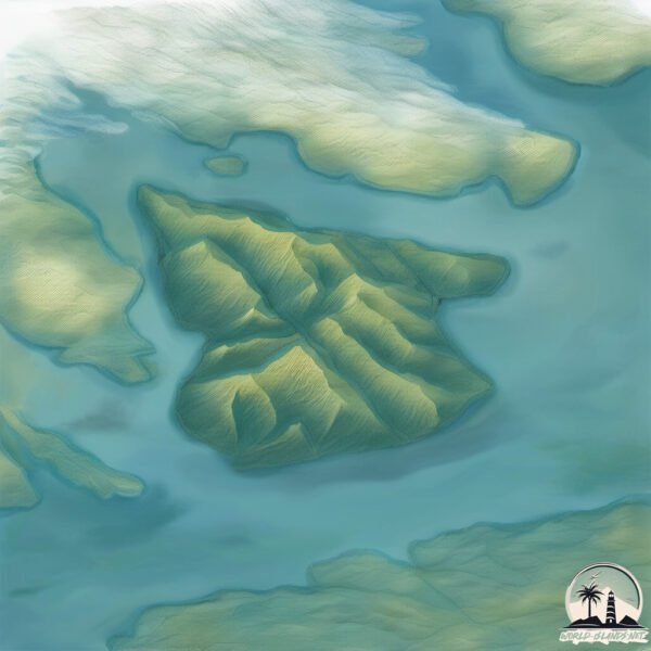
Geography and size of Maniitsoq
Size: 34.2 km²
Coastline: 44.1 km
Ocean: Arctic Ocean
Sea: Davis Strait
Continent: North America
Maniitsoq is a Medium Island spanning 34 km² with a coastline of 44 km.
Archipel: –
Tectonic Plate: Eurasia – One of the world’s largest tectonic plates, the Eurasian Plate covers a significant portion of Europe and Asia. It’s characterized by diverse geological features, including the Ural Mountains, the European Plain, and the Himalayas formed from its collision with the Indian Plate.
The geographic heart of the island is pinpointed at these coordinates:
Latitude: 60.94719135 / Longitude: -46.48087433
Climate and weather of Maniitsoq
Climate Zone: Polar
Climate Details: Tundra
Temperature: Cold
Climate Characteristics: The tundra climate features long, extremely cold winters and short, cool summers. Vegetation is limited to mosses, lichens, and small shrubs due to the low temperatures and short growing seasons. Biodiversity is low, but some specialized species thrive.
Topography and nature of Maniitsoq
Timezone: UTC-03:00
Timezone places: America/Sao_Paulo
Max. Elevation: 487 m
Mean Elevation: 281 m
Vegetation: Herbaceous Cover
Tree Coverage: 17%
The mean elevation is 281 m. The highest elevation on the island reaches approximately 487 meters above sea level. The island is characterized by Hills: Gently sloping landforms with rounded tops, having a maximum elevation between 200 and 500 meters. Hills contribute to a varied landscape on islands.
Dominating Vegetation: Herbaceous Cover
Comprising mainly of grasses, herbs, and ferns, these areas are common in prairies, meadows, and savannas, and can vary widely in species composition. Maniitsoq has a tree cover of 17 %.
Vegetation: 3 vegetation zones – Moderately Diverse Island
These islands start to show a broader range of ecological niches. With three vegetation zones, they may offer a mix of ecosystems like coastal areas, inland woods, and perhaps a distinct wetland or dry area. This diversity supports a wider range of flora and fauna, making these islands more ecologically complex than those with minimal diversity.
Infrastructure and Travelling to Maniitsoq
Does the island have a public airport? no.
There is no public and scheduled airport on Maniitsoq. The nearest airport is Narsaq Heliport, located 40 km away.
Does the island have a major port? no.
There are no major ports on Maniitsoq. The closest major port is NARSAQ, approximately 42 km away.
The mean population of Maniitsoq is 0 per km². Maniitsoq is Uninhabited. The island belongs to Denmark.
The name of the island resonates across different cultures and languages. Here is how it is known around the world: Arabic: جرينلاند; German: Grönland; Spanish: Groenlandia; French: Groenland; Portuguese: Gronelândia; Russian: Гренландия; Chinese: 格陵兰
Continuing your journey, Tuttutooq is the next notable island, situated merely km away.
Grönland Manitsoq ATS 378 NoX


Denmark is classified as Developed region: nonG7: Developed economies outside of the Group of Seven, characterized by high income and advanced economic structures. The level of income is High income: OECD.
News – Latest Updates and Headlines from Maniitsoq
Stay informed with the most recent news and important headlines from Maniitsoq. Here’s a roundup of the latest developments.
Please note: The data used here has been primarily extracted from satellite readings. Deviations from exact values may occur, particularly regarding the height of elevations and population density. Land area and coastline measurements refer to average values at mean high tide.