Marie Galante
Welcome to Marie Galante, a Tropical island in the Caribbean Sea, part of the majestic Atlantic Ocean. This guide offers a comprehensive overview of what makes Marie Galante unique – from its geography and climate to its population, infrastructure, and beyond. Dive into the details:
- Geography and Size: Explore the island’s size and location.
- Climate and Weather: Weather patterns and temperature.
- Topography and Nature: Uncover the natural wonders of the island.
- Infrastructure and Travelling: Insights on reaching, staying, and making the most of your visit.
- News and Headlines: Latest News.
Geography and size of Marie Galante
Size: 160.4 km²
Coastline: 55 km
Ocean: Atlantic Ocean
Sea: Caribbean Sea
Continent: North America
Marie Galante is a Large Island spanning 160 km² with a coastline of 55 km.
Archipel: Lesser Antilles – A long arc of small islands in the Caribbean Sea, stretching from the Virgin Islands to Trinidad, known for their distinct cultures and tropical landscapes.
Tectonic Plate: Scotia – Situated in the Southern Ocean, surrounding the Scotia Sea, between South America and Antarctica, known for the Scotia Arc and active seismicity.
The geographic heart of the island is pinpointed at these coordinates:
Latitude: 15.93165533 / Longitude: -61.26868668
Climate and weather of Marie Galante
Climate Zone: Tropical
Climate Details: Tropical Monsoon Climate
Temperature: Hot
Climate Characteristics: Characterized by heavy rainfall, high humidity, and uniformly high temperatures, but with a distinct short dry season. It features a seasonal reversal of prevailing wind directions.
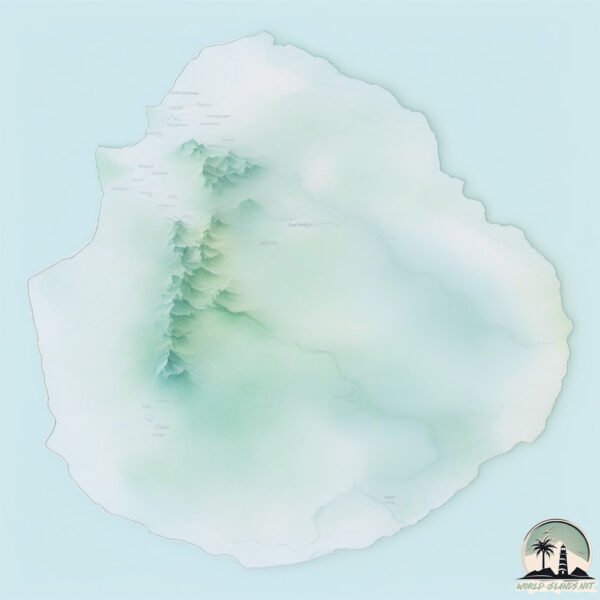
Topography and nature of Marie Galante
Timezone: UTC-04:00
Timezone places: America/La_Paz
Max. Elevation: 168 m
Mean Elevation: 84 m
Vegetation: Agricultural Mosaic
Tree Coverage: 39%
The mean elevation is 84 m. The highest elevation on the island reaches approximately 168 meters above sea level. The island is characterized by Plains: Flat, low-lying lands characterized by a maximum elevation of up to 200 meters. On islands, plains are typically coastal lowlands or central flat areas.
Dominating Vegetation: Agricultural Mosaic
A mix of cropland and natural vegetation, often seen in rural landscapes where agricultural fields are interspersed with patches of natural habitats. Marie Galante has a tree cover of 39 %.
Vegetation: 12 vegetation zones – Exceptionally Diverse Island
Islands with more than ten vegetation zones are among the most ecologically rich and varied in the world. These islands are akin to miniature continents, boasting an incredible array of ecosystems. The sheer range of habitats, from high peaks to deep valleys, rainforests to deserts, creates a mosaic of life that is unparalleled. They are crucial for conservation and ecological studies.
Infrastructure and Travelling to Marie Galante
Does the island have a public airport? yes.
Marie Galante has a public and scheduled airport. The following airports are located on this island: Les Bases Airport.
Does the island have a major port? no.
There are no major ports on Marie Galante. The closest major port is POINTE A PITRE, approximately 37 km away.
The mean population of Marie Galante is 69 per km². Marie Galante is Gently Populated. The island belongs to France.
Continuing your journey, Guadeloupe is the next notable island, situated merely km away.
Marie-Galante, Guadeloupe | Underrated Caribbean Island You Need to See


France is classified as Developed region: G7: Group of Seven – Major advanced economies, including Canada, France, Germany, Italy, Japan, the United Kingdom, and the United States. The level of income is High income: OECD.
News – Latest Updates and Headlines from Marie Galante
Stay informed with the most recent news and important headlines from Marie Galante. Here’s a roundup of the latest developments.
Please note: The data used here has been primarily extracted from satellite readings. Deviations from exact values may occur, particularly regarding the height of elevations and population density. Land area and coastline measurements refer to average values at mean high tide.