Masocarit
Welcome to Masocarit, a Dry island in the Gulf of California, part of the majestic Pacific Ocean. This guide offers a comprehensive overview of what makes Masocarit unique – from its geography and climate to its population, infrastructure, and beyond. Dive into the details:
- Geography and Size: Explore the island’s size and location.
- Climate and Weather: Weather patterns and temperature.
- Topography and Nature: Uncover the natural wonders of the island.
- Infrastructure and Travelling: Insights on reaching, staying, and making the most of your visit.
- News and Headlines: Latest News.
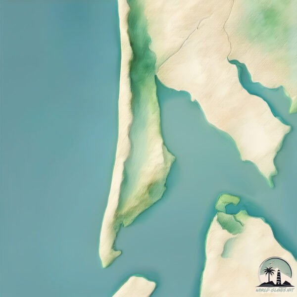
Geography and size of Masocarit
Size: 7.524 km²
Coastline: 19.1 km
Ocean: Pacific Ocean
Sea: Gulf of California
Continent: North America
Masocarit is a Small Island spanning 7.5 km² with a coastline of 19.1 km.
Archipel: –
Tectonic Plate: North America – Covers North America and parts of the Atlantic and Arctic Oceans, characterized by diverse geological features and varying levels of seismic activity.
The geographic heart of the island is pinpointed at these coordinates:
Latitude: 26.36692265 / Longitude: -109.24159979
Climate and weather of Masocarit
Climate Zone: Dry
Climate Details: Hot Semi-Arid (Steppe) Climate
Temperature: Hot
Climate Characteristics: Features hot summers and mild to warm winters. Receives more rainfall than hot deserts but less than tropical savannas, leading to a somewhat more varied landscape.
Topography and nature of Masocarit
Timezone: UTC-07:00
Timezone places: America/Denver
Max. Elevation: 2 m
Mean Elevation: 1 m
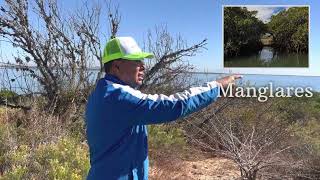
Vegetation: Wetland
Tree Coverage: 95%
The mean elevation is 1 m. The highest elevation on the island reaches approximately 2 meters above sea level. The island is characterized by Plains: Flat, low-lying lands characterized by a maximum elevation of up to 200 meters. On islands, plains are typically coastal lowlands or central flat areas.
Dominating Vegetation: Wetland
These areas are saturated with water, either permanently or seasonally, and support aquatic plants. Wetlands are important for biodiversity and water filtration. Masocarit has a tree cover of 95 %.
Vegetation: 6 vegetation zones – Very Highly Diverse Island
Islands in this range are ecological powerhouses, showcasing a wide array of vegetation zones. Each zone, from lush rainforests to arid scrublands, coastal mangroves to mountainous regions, contributes to a complex and interdependent ecosystem. These islands are often hotspots of biodiversity, supporting numerous species and intricate ecological processes.
Infrastructure and Travelling to Masocarit
Does the island have a public airport? no.
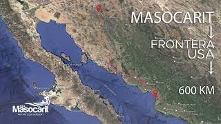
There is no public and scheduled airport on Masocarit. The nearest airport is Valle del Fuerte International Airport, located 75 km away.
Does the island have a major port? no.
There are no major ports on Masocarit. The closest major port is TOPOLOBAMPO, approximately 84 km away.
The mean population of Masocarit is 30 per km². Masocarit is Gently Populated. The island belongs to Mexico.
Continuing your journey, San Ignacio is the next notable island, situated merely km away.
Isla Masocarit Private Club & Resort Vista Panoramica


Mexico is classified as Emerging region: MIKT: Mexico, Indonesia, South Korea, and Turkey – Economies recognized for their development potential and emerging market status. The level of income is Upper middle income.
News – Latest Updates and Headlines from Masocarit
Stay informed with the most recent news and important headlines from Masocarit. Here’s a roundup of the latest developments.
Please note: The data used here has been primarily extracted from satellite readings. Deviations from exact values may occur, particularly regarding the height of elevations and population density. Land area and coastline measurements refer to average values at mean high tide.