Welcome to Mataja, a Tropical island in the Sulu Sea, part of the majestic Pacific Ocean. This guide offers a comprehensive overview of what makes Mataja unique – from its geography and climate to its population, infrastructure, and beyond. Dive into the details:
Geography and size of Mataja
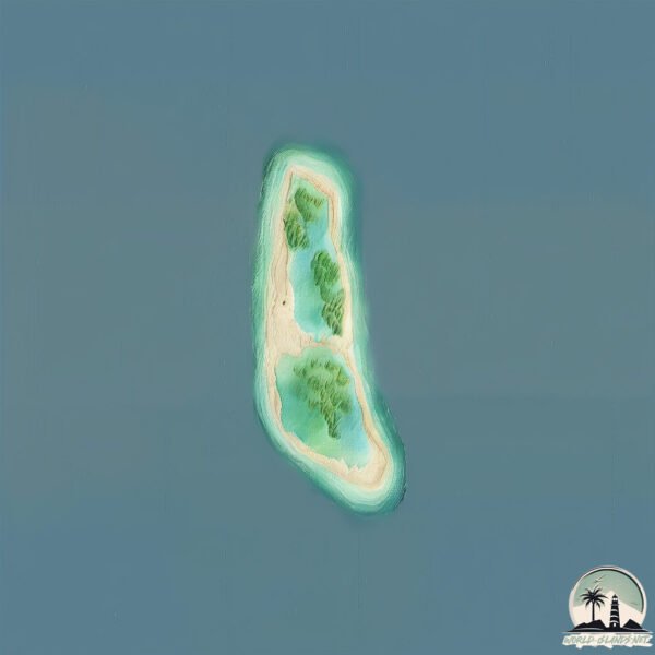
Size: 1.428 km²
Coastline: 6.4 km
Ocean: Pacific Ocean
Sea: Sulu Sea
Continent: Asia
Mataja is a Small Island spanning 1.4 km² with a coastline of 6.4 km.
Archipel: Malay Archipelago – The world’s largest archipelago, located between mainland Southeast Asia and Australia, known for its immense biodiversity and cultural diversity.
Tectonic Plate: Sunda – Extends across Southeast Asia, encompassing parts of the Sunda Shelf, known for its interaction with the Australian Plate, contributing to volcanic activity in Indonesia.
The geographic heart of the island is pinpointed at these coordinates:
Latitude: 6.57442773 / Longitude: 121.69319191
Climate and weather of Mataja
Climate Zone: Tropical
Climate Details: Tropical Rainforest Climate
Temperature: Hot
Climate Characteristics: This climate is typified by heavy rainfall throughout the year, high humidity, and consistently high temperatures, leading to lush rainforests and rich biodiversity. Seasonal temperature variations are minimal.
Topography and nature of Mataja
Timezone: UTC+08:00
Timezone places: Australia/Perth
Max. Elevation: -16 m
Mean Elevation: -24 m
Vegetation: Deciduous Needleleaf Forest
Tree Coverage: 10%
The mean elevation is -24 m. Remarkably, this unique island barely emerges above the sea level, showcasing nature’s fascinating interplay with the ocean. The island is characterized by Plains: Flat, low-lying lands characterized by a maximum elevation of up to 200 meters. On islands, plains are typically coastal lowlands or central flat areas.
Dominating Vegetation: Deciduous Needleleaf Forest
Consists of needleleaf trees that shed their needles annually. This type of forest is less common and can be found in certain cold, northern regions. Mataja has a tree cover of 10 %.
Vegetation: 2 vegetation zones – Low Diversity Island
Islands with two distinct vegetation zones offer slightly more ecological variety. These zones could be due to differences in elevation, moisture, or other environmental factors. While still limited in biodiversity, these islands may offer a contrast between the two zones, such as a coastline with mangroves and an inland area with grassland.
Infrastructure and Travelling to Mataja
Does the island have a public airport? no.
There is no public and scheduled airport on Mataja. The nearest airport is Zamboanga International Airport, located 55 km away.
Does the island have a major port? no.
There are no major ports on Mataja. The closest major port is PORT HOLLAND, approximately 19 km away.
The mean population of Mataja is 51 per km². Mataja is Gently Populated. The island belongs to Philippines.
Continuing your journey, Pilas is the next notable island, situated merely km away.
Basilan: The Underrated Island Paradise of Mindanao; Is it safe to go? Basilan Travel Guide 2025
Basilan is the largest and northernmost island of the Sulu Archipelago, located just across Zamboanga City in Mindanao, ...Basilan: The Underrated Island Paradise of Mindanao; Is it safe to go? Basilan Travel Guide 2025
Basilan is the largest and northernmost island of the Sulu ...
Basilan is the largest and northernmost island of the Sulu Archipelago, located just across Zamboanga City in Mindanao, ...
General Cargo Ship Passing Mataja Island Basilan Province | STINGRAYMAN10
General cargo ship MV FATMA passing Mataja Island, Basilan Province. ...
General cargo ship MV FATMA passing Mataja Island, Basilan Province. Departed from Mauboh Port Patikul Sulu then bound for ...
passing mataja island #seaman
Philippine Island Basilan #philippines #beach
Why I Always Return To This Philippines Island (BASILAN)
I OFTEN COME BACK TO BASILAN. There is just something about it. That ...
I OFTEN COME BACK TO BASILAN. There is just something about it. That approach into Isabela City, with houses on both sides ...
Basilan Beach Walking Tour | Lampinigan Paradise Island | Mindanao Philippine Island Tourism
Basilan Beach Walking Tour | Lampinigan Paradise Island | Mindanao ...
Basilan Beach Walking Tour | Lampinigan Paradise Island | Mindanao Philippine Island Tourism Walking tour at Lampinigan ...
Passing At The Vicinity Of Minis & Mataja Island 🏝️| STINGRAYMAN10
General cargo ship MV FATMA passing at the vicinity of Minis and ...
General cargo ship MV FATMA passing at the vicinity of Minis and Mataja Island 🏝️ bound to General Santos City loaded with ...
Not many of us heard about this ISLAND.
Basilan, officially the Province of Basilan, is an island province of ...
Basilan, officially the Province of Basilan, is an island province of the Philippines located primarily in the Bangsamoro ...
isla ng mataja, basilan#island #fypシ゚viral #nature #subscribe
MY WIFE IN BASILAN - Her First Experience was Beautiful (Becoming Filipino)
WHAT AN AMAZING EXPERIENCE, SPENDING TIME IN BASILAN WITH MY WIFE! ...
WHAT AN AMAZING EXPERIENCE, SPENDING TIME IN BASILAN WITH MY WIFE! This video is just a raw look at a few of the ...
PARADISE ISLAND BASILAN - Giant Lobsters In The Philippines (Tourism Mindanao)
THERE IS A PARADISE ISLAND IN ISABELA DE BASILAN... Welcome to ...
THERE IS A PARADISE ISLAND IN ISABELA DE BASILAN... Welcome to Lampinigan Island!! Usually it takes about a 45 minute ...
Wow Basilan Island 🏝️ Philippines
LAMPINIGAN ISLAND | Basilan | PASYAL PILIPINAS | BPM #shorts #tourism #travel #philippines
Beautiful Philippines Mabuhay special feature Pasyal Pilipinas. ...
Beautiful Philippines Mabuhay special feature Pasyal Pilipinas. Sponsoring this channel will help create original videos for more ...
Philippines : In the island of Basilan
3 more bodies recovered in Basilan; death toll in ferry sinking now at 40 | INQToday
Three more bodies were found a week after the tragic sinking of MV ...
Three more bodies were found a week after the tragic sinking of MV Trisha Kerstin 3 in the waters off Baluk-Baluk Island of Basilan ...
Exploring a hidden paradise in Basilan Philippines !😅😅😅
Basilan is a hidden paradise! The Province of Basilan (Chavacano: ...
Basilan is a hidden paradise! The Province of Basilan (Chavacano: Provincia de Basilan; Tausug: Wilaya' sin Basilan; Yakan: ...
Malamawi Island (Pahali resort) + Isabela De Basilan DIY Tour | Mindanao | ZamBa Vlog 3
Zamboanga- Basilan DIY Trip vlogs: Dennis coffee garden foodtrip and ...
Former captive priest visits Basilan Island
Spanish Claretian missionary priest Bernardo Blanco, who was held ...
Spanish Claretian missionary priest Bernardo Blanco, who was held captive by the terrorist Abu Sayyaf Group on the island of ...
Basilan #youtubeshorts #travel #traveldestinations #motivation #philippinestravel #philippines
Namasyal pa Sinulung Island Basilan
Exploring the City of Basilan
Basilan is an island province of the Philippines in the Autonomous ...
Basilan is an island province of the Philippines in the Autonomous Region in Muslim Mindanao. Basilan Island is the largest and ...
Discovering Basilan 2023 | Not what I expected! | DIY Guide to Malamawi White Beach
[WATCH IN HD!] Welcome to another DENstination - Denver's Travel ...
[WATCH IN HD!] Welcome to another DENstination - Denver's Travel Diaries! Join me as we explore beautiful places in the ...
🇵🇭 BASILAN » (2016) 7-Day Mindanao Backpacking
[BASILAN] ▻ Autonomous Region of Muslim Mindanao, Mindanao, ...
[BASILAN] ▻ Autonomous Region of Muslim Mindanao, Mindanao, Philippines ▻ Here's the second destination of my 7-day ...
Basilan Island. Philippines, Zamboanga.
Blue sea and the tropical island of Basilan with mountains. Seascape ...
Blue sea and the tropical island of Basilan with mountains. Seascape with a tropical island. Zamboanga, Mindanao, Philippines.
Philippines is classified as Emerging region: G20: Group of Twenty – Major economies comprising both developed and emerging countries, representing the world’s largest economies. The level of income is Lower middle income.
News – Latest Updates and Headlines from Mataja
Stay informed with the most recent news and important headlines from Mataja. Here’s a roundup of the latest developments.
Loading...
Please note: The data used here has been primarily extracted from satellite readings. Deviations from exact values may occur, particularly regarding the height of elevations and population density. Land area and coastline measurements refer to average values at mean high tide.