Mauritius
Welcome to Mauritius, a Tropical island in the Indian Ocean, part of the majestic Indian Ocean. This guide offers a comprehensive overview of what makes Mauritius unique – from its geography and climate to its population, infrastructure, and beyond. Dive into the details:
- Geography and Size: Explore the island’s size and location.
- Climate and Weather: Weather patterns and temperature.
- Topography and Nature: Uncover the natural wonders of the island.
- Infrastructure and Travelling: Insights on reaching, staying, and making the most of your visit.
- News and Headlines: Latest News.
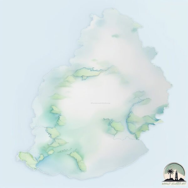
Geography and size of Mauritius
Size: 1873 km²
Coastline: 277 km
Ocean: Indian Ocean
Sea: Indian Ocean
Continent: Seven seas (open ocean)
Mauritius is a Very Large Island spanning 1873 km² with a coastline of 277 km.
Archipel: Mascarene Islands – Located in the Indian Ocean, these islands, including Mauritius and Réunion, are known for their unique wildlife and vibrant cultures.
Tectonic Plate: Somalia – A large tectonic plate covering the Horn of Africa and parts of the Indian Ocean, known for the East African Rift where it’s splitting away from the African Plate.
The geographic heart of the island is pinpointed at these coordinates:
Latitude: -20.2833145 / Longitude: 57.57223224
Climate and weather of Mauritius
Climate Zone: Tropical
Climate Details: Tropical Monsoon Climate
Temperature: Hot
Climate Characteristics: Characterized by heavy rainfall, high humidity, and uniformly high temperatures, but with a distinct short dry season. It features a seasonal reversal of prevailing wind directions.
Topography and nature of Mauritius
Timezone: UTC+04:00
Timezone places: Asia/Dubai
Max. Elevation: 721 m
Mean Elevation: 218 m
Vegetation: Evergreen Broadleaf Forest
Tree Coverage: 39%
The mean elevation is 218 m. The highest elevation on the island reaches approximately 721 meters above sea level. The island is characterized by Plateau: Elevated flatlands rising sharply above the surrounding area, with a maximum elevation over 500 meters but a mean elevation less than 300 meters, forming unique highland areas on islands.
Dominating Vegetation: Evergreen Broadleaf Forest
Characterized by dense, lush canopies of broadleaf trees that retain their leaves year-round. These forests are typically found in tropical and subtropical regions and are known for their high biodiversity. Mauritius has a tree cover of 39 %.
Vegetation: 12 vegetation zones – Exceptionally Diverse Island
Islands with more than ten vegetation zones are among the most ecologically rich and varied in the world. These islands are akin to miniature continents, boasting an incredible array of ecosystems. The sheer range of habitats, from high peaks to deep valleys, rainforests to deserts, creates a mosaic of life that is unparalleled. They are crucial for conservation and ecological studies.
Infrastructure and Travelling to Mauritius
Does the island have a public airport? yes.
Mauritius has a public and scheduled airport. The following airports are located on this island: Sir Seewoosagur Ramgoolam International Airport.
Does the island have a major port? yes.
Mauritius is home to a major port. The following ports are situated on the island: PORT LOUIS.
The mean population of Mauritius is 663 per km². Mauritius is Densely Populated. The island belongs to Mauritius.
The name of the island resonates across different cultures and languages. Here is how it is known around the world: Arabic: جزيرة موريشيوس; German: Mauritius; Spanish: Isla de Mauricio; French: Île Maurice; Portuguese: Maurícia (Ilha); Russian: Маврикий; Chinese: 毛里求斯主岛
Continuing your journey, Reunion is the next notable island, situated merely km away.
10 Best Things To Do In MAURITIUS 2026


Mauritius is classified as Developing region: Regions characterized by lower income levels, with economies in the process of industrialization and modernization. The level of income is Upper middle income.
News – Latest Updates and Headlines from Mauritius
Stay informed with the most recent news and important headlines from Mauritius. Here’s a roundup of the latest developments.
Social Media Posts about Mauritius
Please note: The data used here has been primarily extracted from satellite readings. Deviations from exact values may occur, particularly regarding the height of elevations and population density. Land area and coastline measurements refer to average values at mean high tide.