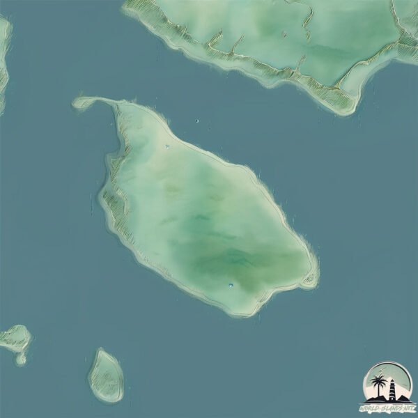
Welcome to McNutts Island, a Continental island in the North Atlantic Ocean, part of the majestic Atlantic Ocean. This guide offers a comprehensive overview of what makes McNutts Island unique – from its geography and climate to its population, infrastructure, and beyond. Dive into the details:
Geography and size of McNutts Island
Size: 9.737 km²
Coastline: 15.7 km
Ocean: Atlantic Ocean
Sea: North Atlantic Ocean
Continent: North America
McNutts Island is a Small Island spanning 9.7 km² with a coastline of 15.7 km.
Archipel: –
Tectonic Plate: North America – Covers North America and parts of the Atlantic and Arctic Oceans, characterized by diverse geological features and varying levels of seismic activity.
The geographic heart of the island is pinpointed at these coordinates:
Latitude: 43.63571651 / Longitude: -65.2861532
Climate and weather of McNutts Island
Climate Zone: Continental
Climate Details: Warm-Summer Humid Continental Climate
Temperature: Warm Summer
Climate Characteristics: Features warm summers and cold winters with consistent precipitation, common in higher latitudes.
Topography and nature of McNutts Island
Timezone: UTC-04:00
Timezone places: America/La_Paz
Max. Elevation: 40 m
Mean Elevation: 21 m
Vegetation: Mixed Forest
Tree Coverage: 87%
The mean elevation is 21 m. The highest elevation on the island reaches approximately 40 meters above sea level. The island is characterized by Plains: Flat, low-lying lands characterized by a maximum elevation of up to 200 meters. On islands, plains are typically coastal lowlands or central flat areas.
Dominating Vegetation: Mixed Forest
A combination of both deciduous and evergreen trees, often found in transitional zones between forest types. These forests offer a diverse habitat for various wildlife species. McNutts Island has a tree cover of 87 %.
Vegetation: 7 vegetation zones – Very Highly Diverse Island
Islands in this range are ecological powerhouses, showcasing a wide array of vegetation zones. Each zone, from lush rainforests to arid scrublands, coastal mangroves to mountainous regions, contributes to a complex and interdependent ecosystem. These islands are often hotspots of biodiversity, supporting numerous species and intricate ecological processes.
Infrastructure and Travelling to McNutts Island
Does the island have a public airport? no.
There is no public and scheduled airport on McNutts Island. The nearest airport is Saint John Airport, located 195 km away.
Does the island have a major port? no.
There are no major ports on McNutts Island. The closest major port is LIVERPOOL (BROOKLYN), approximately 82 km away.
The mean population of McNutts Island is 0 per km². McNutts Island is Uninhabited. The island belongs to Canada.
Continuing your journey, Cape LaHave Island is the next notable island, situated merely km away.
Trip to McNutts Island- Shelburne
I want to show you my favorit place and I a trip with other international students to McNutts Island. Thanks for watching. -AG.Trip to McNutts Island- Shelburne
I want to show you my favorit place and I a trip with other ...
I want to show you my favorit place and I a trip with other international students to McNutts Island. Thanks for watching. -AG.
McNutts Island Shelburne Nova Scotia Camping 2016 Sat Photos
This video was short during a camping trip to McNutts Island located ...
This video was short during a camping trip to McNutts Island located in Shelburne Nova Scotia's Harbour. There was a very short ...
McNutts Island 2015.
I had the chance to go to McNutts Island on July 25-26th. I only ...
I had the chance to go to McNutts Island on July 25-26th. I only managed to get my GoPro out a few times but when I did the ...
McNutts Island Shelburne Nova Scotia Camping trip 2016
Some friends and I went to McNutts for the weekend. Did have much ...
Some friends and I went to McNutts for the weekend. Did have much chance to fly the drone with winds and the sun setting but still ...
Cape Roseway Lighthouse, McNutt's Island Nova Scotia
Atlantic waves crash against McNutt's island, off Nova Scotia's south ...
History of Chinook at McNutt island side channel.
My family's contribution to McKenzie salmon. Circ 1974/5.
My family's contribution to McKenzie salmon. Circ 1974/5.
Island Lake Catskiing - Nick McNutt Edit
In early January 2015, Nick McNutt came up to the lodge to help us ...
In early January 2015, Nick McNutt came up to the lodge to help us start filming a new TV show. The powder was deep and ...
Boating to McNutts Island
McNutts Island Nova Scotia.
McNutts Island Nova Scotia.
Girl Skateboarders - Ryan Donahue + Connor McNutt - Stuff Island #157
Ryan Donahue and Connor McNutt join Stuff Island this week with Chris ...
Ryan Donahue and Connor McNutt join Stuff Island this week with Chris O'Connor. Both Ryan and Connor are standup comics.
Mutton Island - Nova Scotia
Approaching Mutton Island a 12 minute boat ride from Woods Harbour, ...
Approaching Mutton Island a 12 minute boat ride from Woods Harbour, Nova Scotia. Island is about 2km from harbour. Its close ...
Sheep Shearing on McNutt's Island
A collection of various 8mm film clips shot through the years. Edited ...
A collection of various 8mm film clips shot through the years. Edited together by me. Music by freeplaymusic.com. Okay, I lied.
We Went Camping: Five Islands!
We went on a camping trip to Nova Scotia! Where else to find us: ...
We went on a camping trip to Nova Scotia! Where else to find us: NATHALIE Twitter: https://twitter.com/NathGoguen Instagram: ...
Big Tancook Island
Adventure, ahoy! Big Tancook Island is a unique community located off ...
Adventure, ahoy! Big Tancook Island is a unique community located off the coast of mainland Nova Scotia. It is home to a long, ...
Stuff Island #82 - Conner McNutt (feat. LIL FREX)
Comedians Chris O'Connor and Tommy Pope are making all kinds of Stuff ...
Comedians Chris O'Connor and Tommy Pope are making all kinds of Stuff on the patch.. Each week they'll talk about anything ...
he was found looking like this #scary #idksterling #fake
THIS VIDEO IS FAKE ITS JUST FOR ENTERTAINMENT.
THIS VIDEO IS FAKE ITS JUST FOR ENTERTAINMENT.
From GAY To STRAIGHT MUSLIM!☪️😱 *GONE WRONG*😳 #islam #muslim #gay #haram #shorts
From GAY To STRAIGHT MUSLIM!☪️ *GONE WRONG* #islam #muslim #gay #haram ...
From GAY To STRAIGHT MUSLIM!☪️ *GONE WRONG* #islam #muslim #gay #haram #shorts #youtubeshorts #viral #music ...
How did I land this Skate 3 trick…
This Skate 3 Challenge from Skate3Tommy was a MIRACLE #skate3 #gaming.
This Skate 3 Challenge from Skate3Tommy was a MIRACLE #skate3 #gaming.
📍Stoney Island Beach, Cape Sable Island, Nova Scotia
One of the more secluded beaches on Cape Sable Island, walk along the ...
One of the more secluded beaches on Cape Sable Island, walk along the Stoney Island beach and feel the warm silvery sand ...
SHOW THIS TO IDKSTERLING!!!!!
idksterling #ronniemcnutt #sad #dark #truestory #horror #disturbing ...
idksterling #ronniemcnutt #sad #dark #truestory #horror #disturbing #distirbingfacts.
Steve McNutt apple store fashion island good bye
Steve gets clapped out of apple store fashion island after 3 amazing years.
Steve gets clapped out of apple store fashion island after 3 amazing years.
Shelburne Harbour Boat Tours
Boat Tours of Beautiful Shelburne Harbour, Nova Scotia. Join skipper ...
Boat Tours of Beautiful Shelburne Harbour, Nova Scotia. Join skipper Ken and first mate Sherri on a tour of one of Canada's ...
This Is The Most Morbid Invention Ever… 😰 #disturbing
Youtubers that accidentally recorded a live murd3r #shorts
Stuff Island #66 - fancy a waltz w/ Ryan Donahue & Conner McNutt
Stuff Island #66 w/ Ryan Donahue & Conner McNutt - Full episodes also ...
Stuff Island #66 w/ Ryan Donahue & Conner McNutt - Full episodes also available on Apple/Spotify/etc. & bonus episodes are ...
They all just vanished. #Shorts
Canada is classified as Developed region: G7: Group of Seven – Major advanced economies, including Canada, France, Germany, Italy, Japan, the United Kingdom, and the United States. The level of income is High income: OECD.
News – Latest Updates and Headlines from McNutts Island
Stay informed with the most recent news and important headlines from McNutts Island. Here’s a roundup of the latest developments.
Loading...
Please note: The data used here has been primarily extracted from satellite readings. Deviations from exact values may occur, particularly regarding the height of elevations and population density. Land area and coastline measurements refer to average values at mean high tide.