Michael's Cay
Welcome to Michael’s Cay, a Tropical island in the North Atlantic Ocean, part of the majestic Atlantic Ocean. This guide offers a comprehensive overview of what makes Michael’s Cay unique – from its geography and climate to its population, infrastructure, and beyond. Dive into the details:
- Geography and Size: Explore the island’s size and location.
- Climate and Weather: Weather patterns and temperature.
- Topography and Nature: Uncover the natural wonders of the island.
- Infrastructure and Travelling: Insights on reaching, staying, and making the most of your visit.
- News and Headlines: Latest News.
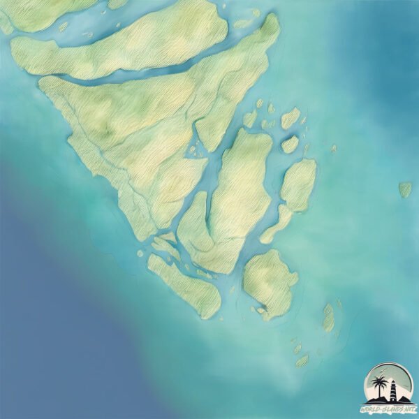
Geography and size of Michael’s Cay
Size: 9.874 km²
Coastline: 33 km
Ocean: Atlantic Ocean
Sea: North Atlantic Ocean
Continent: North America
Michael’s Cay is a Small Island spanning 9.9 km² with a coastline of 33 km.
Archipel: Bahama Islands – An archipelago in the Atlantic Ocean, known for their stunning beaches, coral reefs, and vibrant culture.
Tectonic Plate: North America – Covers North America and parts of the Atlantic and Arctic Oceans, characterized by diverse geological features and varying levels of seismic activity.
The geographic heart of the island is pinpointed at these coordinates:
Latitude: 26.56456656 / Longitude: -77.84038657
Climate and weather of Michael’s Cay
Climate Zone: Tropical
Climate Details: Tropical Monsoon Climate
Temperature: Hot
Climate Characteristics: Characterized by heavy rainfall, high humidity, and uniformly high temperatures, but with a distinct short dry season. It features a seasonal reversal of prevailing wind directions.
Topography and nature of Michael’s Cay
Timezone: UTC-05:00
Timezone places: America/New_York
Max. Elevation: 3 m
Mean Elevation: -1 m
Vegetation: Evergreen Needleleaf Forest
Tree Coverage: 57%
The mean elevation is -1 m. The highest elevation on the island reaches approximately 3 meters above sea level. The island is characterized by Plains: Flat, low-lying lands characterized by a maximum elevation of up to 200 meters. On islands, plains are typically coastal lowlands or central flat areas.
Dominating Vegetation: Evergreen Needleleaf Forest
Dominated by evergreen coniferous trees such as pines and firs, which retain their needle-like leaves throughout the year. These forests are often found in cooler climates. Michael’s Cay has a tree cover of 57 %.
Vegetation: 8 vegetation zones – Very Highly Diverse Island
Islands in this range are ecological powerhouses, showcasing a wide array of vegetation zones. Each zone, from lush rainforests to arid scrublands, coastal mangroves to mountainous regions, contributes to a complex and interdependent ecosystem. These islands are often hotspots of biodiversity, supporting numerous species and intricate ecological processes.
Infrastructure and Travelling to Michael’s Cay
Does the island have a public airport? no.
There is no public and scheduled airport on Michael’s Cay. The nearest airport is Treasure Cay Airport, located 51 km away.
Does the island have a major port? no.
There are no major ports on Michael’s Cay. The closest major port is SOUTH RIDING POINT, approximately 40 km away.
The mean population of Michael’s Cay is 48 per km². Michael’s Cay is Gently Populated. The island belongs to Bahamas.
Continuing your journey, Lightbourn’s Cay is the next notable island, situated merely km away.
Why Michaelmas Cay Should Be Your Next Reef Tour from Cairns Snorkelling + Beach Paradise


Bahamas is classified as Developing region: Regions characterized by lower income levels, with economies in the process of industrialization and modernization. The level of income is High income: nonOECD.
News – Latest Updates and Headlines from Michael’s Cay
Stay informed with the most recent news and important headlines from Michael’s Cay. Here’s a roundup of the latest developments.
Please note: The data used here has been primarily extracted from satellite readings. Deviations from exact values may occur, particularly regarding the height of elevations and population density. Land area and coastline measurements refer to average values at mean high tide.