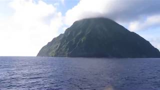
Minamiiō Jima
Welcome to Minamiiō Jima, a Tropical island in the Philippine Sea, part of the majestic Pacific Ocean. This guide offers a comprehensive overview of what makes Minamiiō Jima unique – from its geography and climate to its population, infrastructure, and beyond. Dive into the details:
- Geography and Size: Explore the island’s size and location.
- Climate and Weather: Weather patterns and temperature.
- Topography and Nature: Uncover the natural wonders of the island.
- Infrastructure and Travelling: Insights on reaching, staying, and making the most of your visit.
- News and Headlines: Latest News.
Geography and size of Minamiiō Jima
Size: 3.577 km²
Coastline: 7.5 km
Ocean: Pacific Ocean
Sea: Philippine Sea
Continent: Asia
Minamiiō Jima is a Small Island spanning 3.6 km² with a coastline of 7.5 km.
Archipel: Nanpō Islands – An extension of the Japanese archipelago into the Pacific Ocean, known for their scenic beauty and diverse marine life.
Tectonic Plate: Yangtze – A minor tectonic plate in East Asia, often considered a part of the Eurasian Plate. It’s primarily continental and covers the Yangtze River area in China, playing a significant role in the region’s geological stability.
The geographic heart of the island is pinpointed at these coordinates:
Latitude: 24.23504576 / Longitude: 141.46258978
Climate and weather of Minamiiō Jima
Climate Zone: Tropical
Climate Details: Tropical Monsoon Climate
Temperature: Hot
Climate Characteristics: Characterized by heavy rainfall, high humidity, and uniformly high temperatures, but with a distinct short dry season. It features a seasonal reversal of prevailing wind directions.
Topography and nature of Minamiiō Jima
Timezone: UTC+09:00
Timezone places: Asia/Tokyo
Max. Elevation: 361 m
Mean Elevation: 140 m
Vegetation: Mixed Forest
Tree Coverage: 92%
The mean elevation is 140 m. The highest elevation on the island reaches approximately 361 meters above sea level. The island is characterized by Hills: Gently sloping landforms with rounded tops, having a maximum elevation between 200 and 500 meters. Hills contribute to a varied landscape on islands.
Dominating Vegetation: Mixed Forest
A combination of both deciduous and evergreen trees, often found in transitional zones between forest types. These forests offer a diverse habitat for various wildlife species. Minamiiō Jima has a tree cover of 92 %.
Vegetation: 7 vegetation zones – Very Highly Diverse Island
Islands in this range are ecological powerhouses, showcasing a wide array of vegetation zones. Each zone, from lush rainforests to arid scrublands, coastal mangroves to mountainous regions, contributes to a complex and interdependent ecosystem. These islands are often hotspots of biodiversity, supporting numerous species and intricate ecological processes.
Infrastructure and Travelling to Minamiiō Jima
Does the island have a public airport? no.
There is no public and scheduled airport on Minamiiō Jima. The nearest airport is Hachijojima Airport, located 1003 km away.
Does the island have a major port? no.
There are no major ports on Minamiiō Jima. The closest major port is SAIPAN, approximately 1107 km away.
The mean population of Minamiiō Jima is 48 per km². Minamiiō Jima is Gently Populated. The island belongs to Japan.
Continuing your journey, Iwo Jima is the next notable island, situated merely km away.
Lost Islands (12:46 - :14:34) Minami Iwo To Tokyo


Japan is classified as Developed region: G7: Group of Seven – Major advanced economies, including Canada, France, Germany, Italy, Japan, the United Kingdom, and the United States. The level of income is High income: OECD.
News – Latest Updates and Headlines from Minamiiō Jima
Stay informed with the most recent news and important headlines from Minamiiō Jima. Here’s a roundup of the latest developments.
Please note: The data used here has been primarily extracted from satellite readings. Deviations from exact values may occur, particularly regarding the height of elevations and population density. Land area and coastline measurements refer to average values at mean high tide.