Welcome to Miquelon Langlade, a Continental island in the Gulf of St. Lawrence, part of the majestic Atlantic Ocean. This guide offers a comprehensive overview of what makes Miquelon Langlade unique – from its geography and climate to its population, infrastructure, and beyond. Dive into the details:
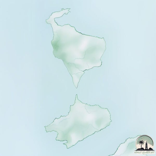
Geography and size of Miquelon Langlade
Size: 197.1 km²
Coastline: 148.9 km
Ocean: Atlantic Ocean
Sea: Gulf of St. Lawrence
Continent: North America
Miquelon Langlade is a Large Island spanning 197 km² with a coastline of 149 km.
Archipel: –
Tectonic Plate: Aegean Sea – Located in the eastern Mediterranean, this microplate is characterized by seismic and volcanic activity due to its interaction with the Eurasian and African Plates.
The geographic heart of the island is pinpointed at these coordinates:
Latitude: 46.95189008 / Longitude: -56.3230467
Climate and weather of Miquelon Langlade
Climate Zone: Continental
Climate Details: Subarctic Climate
Temperature: Cold Summer
Climate Characteristics: Characterized by long, extremely cold winters and short, cool summers, often found in northern latitudes of North America and Eurasia.
Topography and nature of Miquelon Langlade
Timezone: UTC-03:00
Timezone places: America/Miquelon
Max. Elevation: 187 m
Mean Elevation: 74 m
Vegetation: Agricultural Mosaic
Tree Coverage: 44%
The mean elevation is 74 m. The highest elevation on the island reaches approximately 187 meters above sea level. The island is characterized by Plains: Flat, low-lying lands characterized by a maximum elevation of up to 200 meters. On islands, plains are typically coastal lowlands or central flat areas.
Dominating Vegetation: Agricultural Mosaic
A mix of cropland and natural vegetation, often seen in rural landscapes where agricultural fields are interspersed with patches of natural habitats. Miquelon Langlade has a tree cover of 44 %.
Vegetation: 12 vegetation zones – Exceptionally Diverse Island
Islands with more than ten vegetation zones are among the most ecologically rich and varied in the world. These islands are akin to miniature continents, boasting an incredible array of ecosystems. The sheer range of habitats, from high peaks to deep valleys, rainforests to deserts, creates a mosaic of life that is unparalleled. They are crucial for conservation and ecological studies.
Infrastructure and Travelling to Miquelon Langlade
Does the island have a public airport? yes.
Miquelon Langlade has a public and scheduled airport. The following airports are located on this island: Miquelon Airport.
Does the island have a major port? no.
There are no major ports on Miquelon Langlade. The closest major port is PORT DE ST PIERRE, approximately 11 km away.
The mean population of Miquelon Langlade is 3 per km². Miquelon Langlade is Gently Populated. The island belongs to France.
Continuing your journey, St. Pierre is the next notable island, situated merely km away.
Exploring Miquelon Island & Stunning Langlade Beach 🇵🇲
The final stop on my journey through Newfoundland and St. Pierre & Miquelon is Miquelon Island — and it did not disappoint.Exploring Miquelon Island & Stunning Langlade Beach 🇵🇲
The final stop on my journey through Newfoundland and St. Pierre & ...
The final stop on my journey through Newfoundland and St. Pierre & Miquelon is Miquelon Island — and it did not disappoint.
St. Pierre & Miquelon- France’s most awkward island
Miquelon-Langlade | Chapitre I | DJI Mavic 2
Voici de nombreuse images de paysage de Miquelon-Langlade tournées ...
Voici de nombreuse images de paysage de Miquelon-Langlade tournées pendant les 4 saisons ces 3 dernières années, ( AVEC ...
Discovering a Hidden French Overseas Territory in North America ( Saint Pierre & Miquelon, France )
Just off the coast of the Canadian province of Newfoundland & Labrador ...
Just off the coast of the Canadian province of Newfoundland & Labrador lies the last remaining piece of France in North America ...
Miquelon Island
Miquelon also known as Grande Miquelon, is one of the islands of the ...
Miquelon also known as Grande Miquelon, is one of the islands of the archipelago of Saint Pierre and Miquelon, an Overseas ...
France just 45 mins from Canada... Have you heard of Saint Pierre & Miquelon? 🇫🇷🤯 #france #canada
France 20km from Canada Did you know you can visit France in just 45 ...
France 20km from Canada Did you know you can visit France in just 45 minutes from Canada?! Saint-Pierre & Miquelon is ...
Newfoundland Travel Guide: Saint Pierre and Miquelon Vacation - North America's France
Welcome to St. Pierre et Miquelon, a slice of France in North America! ...
Welcome to St. Pierre et Miquelon, a slice of France in North America! Saint Pierre and Miquelon to Canada is only 25 kilometres!
Saint Pierre & Miquelon: The Island you might never have heard before
A Little Piece of France, Just an Hour from Canada! I spent a week in ...
A Little Piece of France, Just an Hour from Canada! I spent a week in Saint Pierre & Miquelon with a friend, exploring both islands ...
Two Countries in Two Days! | Saint Pierre & Miquelon + St. John’s
Saint Pierre et Miquelon - LANGLADE HIVER 2020
Ces vidéos sont prises avec un Iphone et un stabilisateur, c'est un ...
Ces vidéos sont prises avec un Iphone et un stabilisateur, c'est un loisir avant tout ainsi qu'une envie de partager quelques ...
Saint-Pierre and Miquelon: French Atlantic islands with timeless charm.
Off the coast of Canada, I explored Saint-Pierre, Miquelon, and ...
Off the coast of Canada, I explored Saint-Pierre, Miquelon, and Île-aux-Marins. A French enclave frozen in time, between Atlantic ...
St Pierre & Miquelon#france #newfoundland #canada
Why you need to visit Saint Pierre and Miquelon! 🇫🇷
Welcome to our travel guide of Saint-Pierre and Miquelon — a tiny ...
Welcome to our travel guide of Saint-Pierre and Miquelon — a tiny piece of France off the coast of Newfoundland! Just a ...
St-Pierre-Miquelon - N.L. smuggling now goes both ways
RCMP now targeting drug shipments to French islands, in addition to ...
RCMP now targeting drug shipments to French islands, in addition to booze headed to Newfoundland. For the full story: ...
Langlade - Saint-Pierre-Et-Miquelon
Langlade, archipel de Saint-Pierre et Miquelon. Nature et couleurs ...
Langlade, archipel de Saint-Pierre et Miquelon. Nature et couleurs d'automne.
The charm of Saint-Pierre and Miquelon, a French archipelago off the coast of Canada
It's a scattering of French soil off the coast of #Canada. For two ...
It's a scattering of French soil off the coast of #Canada. For two centuries, the archipelago of Saint-Pierre and Miquelon, with its ...
W5: France's best-kept secret in North America
Many Canadians may not realize that the United States isn't the only ...
Many Canadians may not realize that the United States isn't the only country that Canada shares a border with. W5's Kevin ...
7 Reasons to Visit St. Pierre et Miquelon this Summer! #stpierre #stpierreetmiquelon #travel #france
Did you know that France is only a 1hr and 15 minute flight from ...
Did you know that France is only a 1hr and 15 minute flight from Halifax, Nova Scotia? Here are 7 great reasons to visit the French ...
Island-Hopping: A bit of France closer to home
They may appear on the map to be a part of Canada. But for more than a ...
They may appear on the map to be a part of Canada. But for more than a century, the tiny islands of Saint Pierre and Miquelon, ...
Langlade, Saint Pierre et Miquelon
Diaporama sur Langlade.
Diaporama sur Langlade.
Les joies de Langlade - Episode 1 - Saint-Pierre et Miquelon
Retour en images sur un endroit très fréquenté de l'archipel de ...
Retour en images sur un endroit très fréquenté de l'archipel de Saint-Pierre et Miquelon à la belle saison. Langlade est un coin ...
Miquelon-Langlade | Chapitre II | DJI Mavic 2
Voici de nombreuse images de paysage de Miquelon-Langlade tournées ...
Voici de nombreuse images de paysage de Miquelon-Langlade tournées pendant les 4 saisons ces 3 dernières années, ( AVEC ...
Saint-Pierre-et-Miquelon : Nature
tourism #nature #saintpierreetmiquelon #spmexception Discover ...
tourism #nature #saintpierreetmiquelon #spmexception Discover Saint-Pierre & Miquelon, des îles d'exception. Offering diverse ...
MIQUELON, la double insularité (2017) [SAINT-PIERRE-ET-MIQUELON]
https://amzn.to/2SnBcE7. La commune de Miquelon-Langlade est formée de deux presqu'îles reliées par un isthme de sable.
A Day in St. Pierre - St. Pierre and Miquelon
If you are taking a cruise that stops in St. Pierre and Miquelon, ...
If you are taking a cruise that stops in St. Pierre and Miquelon, don't miss the sites highlighted in this video during your visit.
France is classified as Developed region: G7: Group of Seven – Major advanced economies, including Canada, France, Germany, Italy, Japan, the United Kingdom, and the United States. The level of income is High income: OECD.
News – Latest Updates and Headlines from Miquelon Langlade
Stay informed with the most recent news and important headlines from Miquelon Langlade. Here’s a roundup of the latest developments.
Loading...
Please note: The data used here has been primarily extracted from satellite readings. Deviations from exact values may occur, particularly regarding the height of elevations and population density. Land area and coastline measurements refer to average values at mean high tide.


![MIQUELON, la double insularité (2017) [SAINT-PIERRE-ET-MIQUELON]](https://i.ytimg.com/vi/IT8b1i4c9-g/mqdefault.jpg)
