Money Island
Welcome to Money Island, a Tropical island in the South China Sea, part of the majestic Pacific Ocean. This guide offers a comprehensive overview of what makes Money Island unique – from its geography and climate to its population, infrastructure, and beyond. Dive into the details:
- Geography and Size: Explore the island’s size and location.
- Climate and Weather: Weather patterns and temperature.
- Topography and Nature: Uncover the natural wonders of the island.
- Infrastructure and Travelling: Insights on reaching, staying, and making the most of your visit.
- News and Headlines: Latest News.
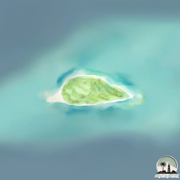
Geography and size of Money Island
Size: 0.358 km²
Coastline: 2.7 km
Ocean: Pacific Ocean
Sea: South China Sea
Continent: Asia
Money Island is a Tiny Island spanning 0.358 km² with a coastline of 2.7 km.
Archipel: Paracel Islands – A group of islands in the South China Sea, subject to territorial disputes, known for their strategic location and rich fishing grounds.
Tectonic Plate: Sunda – Extends across Southeast Asia, encompassing parts of the Sunda Shelf, known for its interaction with the Australian Plate, contributing to volcanic activity in Indonesia.
The geographic heart of the island is pinpointed at these coordinates:
Latitude: 16.4477553 / Longitude: 111.50745951
Climate and weather of Money Island
Climate Zone: Tropical
Climate Details: Tropical Savanna, Wet
Temperature: Hot
Climate Characteristics: Defined by distinct wet and dry seasons with high temperatures year-round. Pronounced rainfall occurs during the wet season, while the dry season is marked by drought.
Topography and nature of Money Island
Timezone: UTC+07:00
Timezone places: Asia/Jakarta
Max. Elevation: 1 m
Mean Elevation: 0 m
Vegetation: Sparse Vegetation
Tree Coverage: 67%
The mean elevation is 0 m. The highest elevation on the island reaches approximately 1 meters above sea level. The island is characterized by Plains: Flat, low-lying lands characterized by a maximum elevation of up to 200 meters. On islands, plains are typically coastal lowlands or central flat areas.
Dominating Vegetation: Sparse Vegetation
These regions have limited plant growth, typically due to extreme conditions like aridity or poor soils. Vegetation is scattered and consists of hardy plant species. Money Island has a tree cover of 67 %.
Vegetation: 1 vegetation zones – Minimal Diversity Island
These islands exhibit the most basic level of ecological diversity, often characterized by a single dominant vegetation type. This could be due to extreme environmental conditions, limited land area, or significant human impact. They represent unique ecosystems where specific species have adapted to thrive in these singular environments.
Infrastructure and Travelling to Money Island
Does the island have a public airport? no.
There is no public and scheduled airport on Money Island. The nearest airport is Yongxing Dao (Woody Island) Airport, located 102 km away.
Does the island have a major port? no.
There are no major ports on Money Island. The closest major port is SANYA, approximately 308 km away.
The mean population of Money Island is per km². Money Island is . The island belongs to China.
Continuing your journey, Cù Lao Chàm is the next notable island, situated merely km away.
[I-LAND2/9회 풀버전] '김수정, 마이, 방지민, 손주원, 정세비' ♬MONEY - LISA @메인 포지션 테스트 '메인 댄서'
![[I-LAND2/9회 풀버전] '김수정, 마이, 방지민, 손주원, 정세비' ♬MONEY - LISA @메인 포지션 테스트 '메인 댄서'](https://i.ytimg.com/vi/_dF2sGqDJ_M/mqdefault.jpg)
![[I-LAND2/9회] '김수정, 마이, 방지민, 손주원, 정세비' ♬MONEY - LISA @메인 포지션 테스트 '메인 댄서' | Mnet 240620 방송](https://i.ytimg.com/vi/g8e8NEtPIhM/mqdefault.jpg)

China is classified as Emerging region: BRIC: Brazil, Russia, India, and China – Economies noted for their rapid growth and increasing influence on global affairs. The level of income is Upper middle income.
News – Latest Updates and Headlines from Money Island
Stay informed with the most recent news and important headlines from Money Island. Here’s a roundup of the latest developments.
Please note: The data used here has been primarily extracted from satellite readings. Deviations from exact values may occur, particularly regarding the height of elevations and population density. Land area and coastline measurements refer to average values at mean high tide.