Montagu
Welcome to Montagu, a Polar island in the South Atlantic Ocean, part of the majestic Atlantic Ocean. This guide offers a comprehensive overview of what makes Montagu unique – from its geography and climate to its population, infrastructure, and beyond. Dive into the details:
- Geography and Size: Explore the island’s size and location.
- Climate and Weather: Weather patterns and temperature.
- Topography and Nature: Uncover the natural wonders of the island.
- Infrastructure and Travelling: Insights on reaching, staying, and making the most of your visit.
- News and Headlines: Latest News.
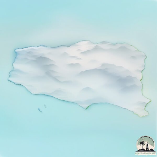
Geography and size of Montagu
Size: 104.2 km²
Coastline: 48.4 km
Ocean: Atlantic Ocean
Sea: South Atlantic Ocean
Continent: Seven seas (open ocean)
Montagu is a Large Island spanning 104 km² with a coastline of 48 km.
Archipel: South Sandwich Islands – A British overseas territory in the southern Atlantic Ocean, consisting of 11 volcanic islands. Notable for their rich marine wildlife and untouched landscapes.
Tectonic Plate: Sandwich – Situated in the southern Atlantic Ocean, it’s known for the Sandwich Trench and active volcanic arcs, resulting from the subduction of the South American Plate.
The geographic heart of the island is pinpointed at these coordinates:
Latitude: -58.45176045 / Longitude: -26.36592089
Climate and weather of Montagu
Climate Zone: Polar
Climate Details: Ice Cap
Temperature: Cold
Climate Characteristics: The ice cap climate is the most extreme of the polar climates, characterized by a permanently frozen landscape. Temperatures rarely, if ever, rise above freezing, resulting in a barren, ice-covered environment with very little precipitation and no plant or animal life.
Topography and nature of Montagu
Timezone: UTC-02:00
Timezone places: Atlantic/South_Georgia
Max. Elevation: -1 m
Mean Elevation: -116 m
Vegetation: Snow and Ice Covered
Tree Coverage: 13%
The mean elevation is -116 m. Remarkably, this unique island barely emerges above the sea level, showcasing nature’s fascinating interplay with the ocean. The island is characterized by Plains: Flat, low-lying lands characterized by a maximum elevation of up to 200 meters. On islands, plains are typically coastal lowlands or central flat areas.
Dominating Vegetation: Snow and Ice Covered
These areas are permanently or seasonally covered in snow and ice, with little to no vegetation, such as polar regions and high mountains. Montagu has a tree cover of 13 %.
Vegetation: 8 vegetation zones – Very Highly Diverse Island
Islands in this range are ecological powerhouses, showcasing a wide array of vegetation zones. Each zone, from lush rainforests to arid scrublands, coastal mangroves to mountainous regions, contributes to a complex and interdependent ecosystem. These islands are often hotspots of biodiversity, supporting numerous species and intricate ecological processes.
Infrastructure and Travelling to Montagu
Does the island have a public airport? no.
There is no public and scheduled airport on Montagu. The nearest airport is Port Stanley Airport, located 3558 km away.
Does the island have a major port? no.
There are no major ports on Montagu. The closest major port is GRYTVIKEN, approximately 1206 km away.
The mean population of Montagu is per km². Montagu is . The island belongs to United Kingdom.
Continuing your journey, Bristol is the next notable island, situated merely km away.
How to Get To Montague Island and Tour the Island - NSW South Coast

United Kingdom is classified as Developed region: G7: Group of Seven – Major advanced economies, including Canada, France, Germany, Italy, Japan, the United Kingdom, and the United States. The level of income is High income: OECD.
News – Latest Updates and Headlines from Montagu
Stay informed with the most recent news and important headlines from Montagu. Here’s a roundup of the latest developments.
Please note: The data used here has been primarily extracted from satellite readings. Deviations from exact values may occur, particularly regarding the height of elevations and population density. Land area and coastline measurements refer to average values at mean high tide.