Morley Island

Welcome to Morley Island, a Dry island in the Indian Ocean, part of the majestic Indian Ocean. This guide offers a comprehensive overview of what makes Morley Island unique – from its geography and climate to its population, infrastructure, and beyond. Dive into the details:
- Geography and Size: Explore the island’s size and location.
- Climate and Weather: Weather patterns and temperature.
- Topography and Nature: Uncover the natural wonders of the island.
- Infrastructure and Travelling: Insights on reaching, staying, and making the most of your visit.
- News and Headlines: Latest News.
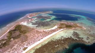
Geography and size of Morley Island
Size: 0.148 km²
Coastline: 2.9 km
Ocean: Indian Ocean
Sea: Indian Ocean
Continent: Oceania
Morley Island is a Tiny Island spanning 0.148 km² with a coastline of 2.9 km.
Archipel: –
Tectonic Plate: Australia – A major tectonic plate covering Australia, New Zealand, and parts of the Indian and Pacific Oceans, known for its relative stability and occasional seismic activity.
The geographic heart of the island is pinpointed at these coordinates:
Latitude: -28.7450203 / Longitude: 113.8136773
Climate and weather of Morley Island
Climate Zone: Dry
Climate Details: Hot Semi-Arid (Steppe) Climate
Temperature: Hot
Climate Characteristics: Features hot summers and mild to warm winters. Receives more rainfall than hot deserts but less than tropical savannas, leading to a somewhat more varied landscape.
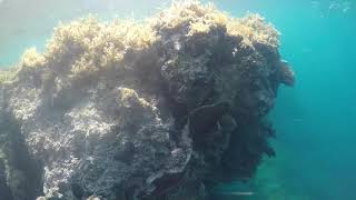
Topography and nature of Morley Island
Timezone: UTC+08:00
Timezone places: Australia/Perth
Max. Elevation: -12 m
Mean Elevation: -13 m
Vegetation: Cultivated Land
Tree Coverage: 95%
The mean elevation is -13 m. Remarkably, this unique island barely emerges above the sea level, showcasing nature’s fascinating interplay with the ocean. The island is characterized by Plains: Flat, low-lying lands characterized by a maximum elevation of up to 200 meters. On islands, plains are typically coastal lowlands or central flat areas.
Dominating Vegetation: Cultivated Land
Areas dedicated to agricultural activities, growing crops like grains, vegetables, and fruits. These lands are usually human-modified landscapes. Morley Island has a tree cover of 95 %.
Vegetation: 1 vegetation zones – Minimal Diversity Island
These islands exhibit the most basic level of ecological diversity, often characterized by a single dominant vegetation type. This could be due to extreme environmental conditions, limited land area, or significant human impact. They represent unique ecosystems where specific species have adapted to thrive in these singular environments.
Infrastructure and Travelling to Morley Island
Does the island have a public airport? no.
There is no public and scheduled airport on Morley Island. The nearest airport is Geraldton Airport, located 99 km away.
Does the island have a major port? no.
There are no major ports on Morley Island. The closest major port is GERALDTON, approximately 87 km away.
The mean population of Morley Island is 0 per km². Morley Island is Uninhabited. The island belongs to Australia.
Continuing your journey, Faure is the next notable island, situated merely km away.
Morley Island

Australia is classified as Developed region: nonG7: Developed economies outside of the Group of Seven, characterized by high income and advanced economic structures. The level of income is High income: OECD.
News – Latest Updates and Headlines from Morley Island
Stay informed with the most recent news and important headlines from Morley Island. Here’s a roundup of the latest developments.
Please note: The data used here has been primarily extracted from satellite readings. Deviations from exact values may occur, particularly regarding the height of elevations and population density. Land area and coastline measurements refer to average values at mean high tide.