Welcome to Morotai, a Tropical island in the Molukka Sea, part of the majestic Pacific Ocean. This guide offers a comprehensive overview of what makes Morotai unique – from its geography and climate to its population, infrastructure, and beyond. Dive into the details:
Geography and size of Morotai
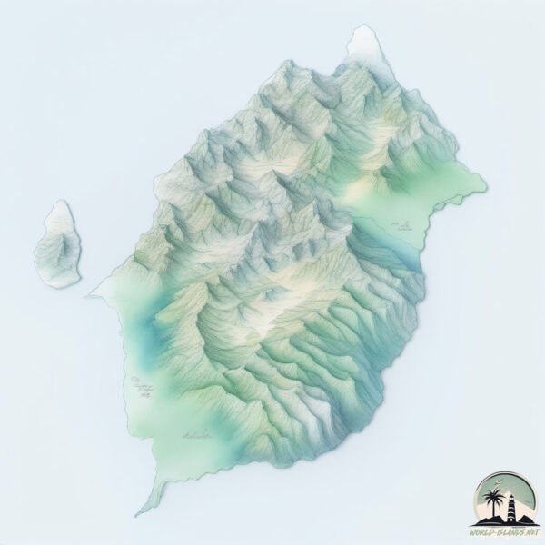
Size: 2291 km²
Coastline: 263 km
Ocean: Pacific Ocean
Sea: Molukka Sea
Continent: Oceania
Morotai is a Very Large Island spanning 2291 km² with a coastline of 263 km.
Archipel: Melanesia – A subregion of Oceania in the southwestern Pacific Ocean, including countries like Fiji, Solomon Islands, and Vanuatu, known for their diverse cultures and languages.
Tectonic Plate: Sunda – Extends across Southeast Asia, encompassing parts of the Sunda Shelf, known for its interaction with the Australian Plate, contributing to volcanic activity in Indonesia.
The geographic heart of the island is pinpointed at these coordinates:
Latitude: 2.31652622 / Longitude: 128.45695795
Climate and weather of Morotai
Climate Zone: Tropical
Climate Details: Tropical Rainforest Climate
Temperature: Hot
Climate Characteristics: This climate is typified by heavy rainfall throughout the year, high humidity, and consistently high temperatures, leading to lush rainforests and rich biodiversity. Seasonal temperature variations are minimal.
Topography and nature of Morotai
Timezone: UTC+09:00
Timezone places: Asia/Tokyo
Max. Elevation: 1143 m
Mean Elevation: 284 m
Vegetation: Evergreen Broadleaf Forest
Tree Coverage: 75%
The mean elevation is 284 m. The highest elevation on the island reaches approximately 1143 meters above sea level. The island is characterized by Plateau: Elevated flatlands rising sharply above the surrounding area, with a maximum elevation over 500 meters but a mean elevation less than 300 meters, forming unique highland areas on islands.
Dominating Vegetation: Evergreen Broadleaf Forest
Characterized by dense, lush canopies of broadleaf trees that retain their leaves year-round. These forests are typically found in tropical and subtropical regions and are known for their high biodiversity. Morotai has a tree cover of 75 %.
Vegetation: 11 vegetation zones – Exceptionally Diverse Island
Islands with more than ten vegetation zones are among the most ecologically rich and varied in the world. These islands are akin to miniature continents, boasting an incredible array of ecosystems. The sheer range of habitats, from high peaks to deep valleys, rainforests to deserts, creates a mosaic of life that is unparalleled. They are crucial for conservation and ecological studies.
Infrastructure and Travelling to Morotai
Does the island have a public airport? no.
There is no public and scheduled airport on Morotai. The nearest airport is Buli Airport, located 119 km away.
Does the island have a major port? no.
There are no major ports on Morotai. The closest major port is TERNATE, approximately 165 km away.
The mean population of Morotai is 38 per km². Morotai is Gently Populated. The island belongs to Indonesia.
The name of the island resonates across different cultures and languages. Here is how it is known around the world: Arabic: هالماهيرا; German: Halmahera; Spanish: Halmahera; French: Halmahera; Portuguese: Halmaera; Russian: Хальмахера; Chinese: 哈马黑拉岛
Continuing your journey, Pulau Rau is the next notable island, situated merely km away.
Morotai Island Drone View l Battle of Morotai - Battle
DRONE Compilation by Coastal garage pengambilan menggunakan DJI phantom 3pro ...Morotai Island Drone View l Battle of Morotai - Battle
DRONE Compilation by Coastal garage pengambilan menggunakan DJI ...
DRONE Compilation by Coastal garage pengambilan menggunakan DJI phantom 3pro ...
War Crimes Trials on Morotai Island
War Crimes Trials on Morotai Island With David Gormley-O'Brien Part of ...
War Crimes Trials on Morotai Island With David Gormley-O'Brien Part of our War Crimes Trials - Investigations, Trials and ...
WE STAYED IN A REMOTE VILLAGE | MOROTAI ISLAND EP.7
halmahera #morotai #travelvlog One of our craziest adventures but not ...
halmahera #morotai #travelvlog One of our craziest adventures but not because it was fast pace and covered a lot of ground but ...
Stepping a foot out of BALI - Morotai's Secret Beaches
Today we explore the three most beautiful beaches on Morotai Island ...
Today we explore the three most beautiful beaches on Morotai Island and show you our day trip, without crowded beaches and ...
Exploring Morotai island By Motorbike in Indonesia
We hired some motorbikes for a few hours on Morotai Island in ...
We hired some motorbikes for a few hours on Morotai Island in Indonesia and did some exploring, we visited quite a few villages, ...
Morotai: Mutiara di Bibir Pasifik
Tempochannel.com | Menyelam bersama hiu dan menelusuri bangkai kapal ...
Tempochannel.com | Menyelam bersama hiu dan menelusuri bangkai kapal perang dunia II, hanya mungkin didapat saat ...
Exploring Unknown Islands (Rao island, Morotai, Maluku)
Exploring Rao Island in North Maluku, Indonesia Join me as I uncover ...
Exploring Rao Island in North Maluku, Indonesia Join me as I uncover the hidden treasures of Rao Island, a remote paradise ...
The Wonderful Moluccas - Morotai Island
The most northern island of the Indonesian archipelago, Morotai is a ...
The most northern island of the Indonesian archipelago, Morotai is a little fleck of coral and forests, floating up into the South ...
Morotai & Maluku islands Surfing
Myself and Guy Morgan Delivered the Solo Gracia(Mentawai Surf Co) Surf ...
Myself and Guy Morgan Delivered the Solo Gracia(Mentawai Surf Co) Surf Charter boat to the Morotai/Maluku Islands for their ...
See Indonesia: Morotai, The Pearl Of The Pacific
Welcome to the Pearl of the Pacific, Morotai. One of Indonesia's Top ...
Welcome to the Pearl of the Pacific, Morotai. One of Indonesia's Top Ten Tourist Destination. A one of a kind location where you'd ...
See Indonesia: Morotai, The Land Of Stories
Morotai, a quiet island on the north of Halmahera, Eastern Maluku ...
Morotai, a quiet island on the north of Halmahera, Eastern Maluku Island has loud history within. In this episode we're gonna ...
morotai part #1 Freediving at bristol beaufort wreck ww2
Amazing Morotai island !!! INDONESIA !!!! Melanesia freedive at ...
Amazing Morotai island !!! INDONESIA !!!! Melanesia freedive at bristol beaufort wreck ww2 ( wawama point ) morotai island ...
Diving Morotai - Wreck dive and blacktip shark point
Diving at the one of outer most island Indonesia, Morotai. History is ...
Diving at the one of outer most island Indonesia, Morotai. History is one of the most attractive point for visitors who come to Morotai ...
6 Best Marine Places to Visit in Morotai Indonesia
6 lokasi yang sayang dilewatkan jika berkunjunga Ke Pulau Morotai 1. ...
6 lokasi yang sayang dilewatkan jika berkunjunga Ke Pulau Morotai 1. Pantai Army Dock 2. Pulau Dodola 3. Pulau Pasir Putih 4.
Morotai Island - Hidden Paradise in East Indonesia
Pulau Morotai adalah nama pulau yang berada di kepulauan Maluku Utara, ...
Pulau Morotai adalah nama pulau yang berada di kepulauan Maluku Utara, pulau terdepan Indonesia yang posisinya ...
Invest in the Hidden Gem, the Pristine Morotai Island
The Morotai Island, known as the 'Pearl on the Lip of Pacific', is a ...
The Morotai Island, known as the 'Pearl on the Lip of Pacific', is a paradise for the angel birds, a rare and protected species.
HOW DID THEY TALK US INTO THIS? | MOROTAI ISLAND EP.8
halmahera #morotai #travelvlog One of our craziest adventures but not ...
halmahera #morotai #travelvlog One of our craziest adventures but not because it was fast pace and covered a lot of ground but ...
Morotai: Mutiara Cantik di Bibir Pasifik | Indonesia Plus tvOne
Indonesia Plus,
https://www.tvOnenews.com - Morotai: Mutiara Cantik di Bibir Pasifik | Indonesia Plus tvOne Terletak di utara ...
Another Story from Morotai Island
Morotai – An island located in the most northern part of North Maluku ...
Morotai – An island located in the most northern part of North Maluku province, Morotai was part of the Ternate Sultanate - a ...
World War II history in MOROTAI Island, North Maluku (Indonesia).
This video is about World War II history in MOROTAI Island, North ...
This video is about World War II history in MOROTAI Island, North Maluku (2017). The Large US ARMY Base Camp.
PESONA ALAM PULAU MOROTAI BERSAMA TRAVELOKA
Pulau Morotai adalah saksi bisu Perang Dunia II, tempat tentara Jepang ...
Pulau Morotai adalah saksi bisu Perang Dunia II, tempat tentara Jepang mendirikan basis pertahanan mereka sebelum diambil ...
Morotai Island Development
Development companies from Taiwan and Indonesia met in Taipei today to ...
Development companies from Taiwan and Indonesia met in Taipei today to sign an agreement setting up a special economic ...
Indonesia is classified as Emerging region: MIKT: Mexico, Indonesia, South Korea, and Turkey – Economies recognized for their development potential and emerging market status. The level of income is Lower middle income.
News – Latest Updates and Headlines from Morotai
Stay informed with the most recent news and important headlines from Morotai. Here’s a roundup of the latest developments.
Loading...
Social Media Posts about Morotai
Loading...
Please note: The data used here has been primarily extracted from satellite readings. Deviations from exact values may occur, particularly regarding the height of elevations and population density. Land area and coastline measurements refer to average values at mean high tide.