Welcome to Motu Mute, a Tropical island in the South Pacific Ocean, part of the majestic Pacific Ocean. This guide offers a comprehensive overview of what makes Motu Mute unique – from its geography and climate to its population, infrastructure, and beyond. Dive into the details:
Geography and size of Motu Mute
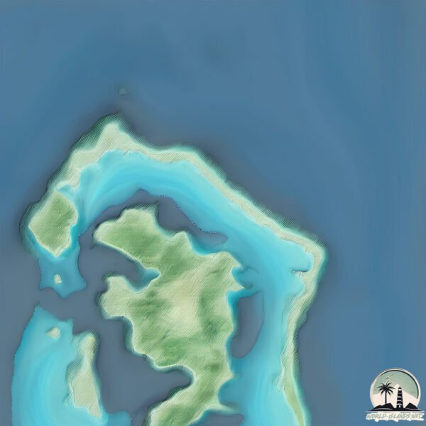
Size: 4.089 km²
Coastline: 28.2 km
Ocean: Pacific Ocean
Sea: South Pacific Ocean
Continent: Oceania
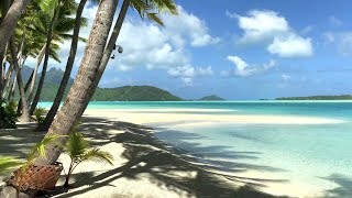
Motu Mute is a Small Island spanning 4.1 km² with a coastline of 28.2 km.
Archipel: Society Islands – A group of islands in the South Pacific Ocean, part of French Polynesia, famous for their idyllic beauty, including Tahiti and Bora Bora.
Tectonic Plate: Pacific – The world’s largest tectonic plate, covering much of the Pacific Ocean, known for the Pacific Ring of Fire with extensive seismic and volcanic activity.
The geographic heart of the island is pinpointed at these coordinates:
Latitude: -16.46116768 / Longitude: -151.7240379
Climate and weather of Motu Mute
Climate Zone: Tropical
Climate Details: Tropical Rainforest Climate
Temperature: Hot
Climate Characteristics: This climate is typified by heavy rainfall throughout the year, high humidity, and consistently high temperatures, leading to lush rainforests and rich biodiversity. Seasonal temperature variations are minimal.
Topography and nature of Motu Mute
Timezone: UTC-10:00
Timezone places: Pacific/Honolulu
Max. Elevation: 3 m
Mean Elevation: -10 m
Vegetation: Agricultural Mosaic
Tree Coverage: 40%
The mean elevation is -10 m. The highest elevation on the island reaches approximately 3 meters above sea level. The island is characterized by Plains: Flat, low-lying lands characterized by a maximum elevation of up to 200 meters. On islands, plains are typically coastal lowlands or central flat areas.
Dominating Vegetation: Agricultural Mosaic
A mix of cropland and natural vegetation, often seen in rural landscapes where agricultural fields are interspersed with patches of natural habitats. Motu Mute has a tree cover of 40 %.
Vegetation: 5 vegetation zones – Highly Diverse Island
With five different vegetation zones, these islands offer a rich tapestry of ecosystems. The variety could include dense forests, open meadows, wetlands, coastal zones, and more. This level of diversity supports an intricate web of life, with each zone playing a vital role in the overall ecological health and balance of the island.
Infrastructure and Travelling to Motu Mute
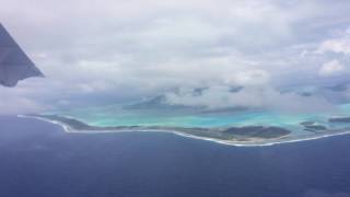
Does the island have a public airport? yes.
Motu Mute has a public and scheduled airport. The following airports are located on this island: Bora Bora Airport.
Does the island have a major port? no.
There are no major ports on Motu Mute. The closest major port is VAITAPE, approximately 5 km away.
The mean population of Motu Mute is 422 per km². Motu Mute is Moderately Inhabited. The island belongs to France.
Continuing your journey, Bora Bora is the next notable island, situated merely km away.
BORA BORA AIRPORT - MOTU MUTE
Video from Bora Bora Airport. Its a very small aiport located in Motu Mute atol. Everyone can use free ferry transport to main island ...BORA BORA AIRPORT - MOTU MUTE
Video from Bora Bora Airport. Its a very small aiport located in Motu ...
Video from Bora Bora Airport. Its a very small aiport located in Motu Mute atol. Everyone can use free ferry transport to main island ...
Impossible Hard Landing Of Antonov An225 At Motu Mute, Bora Bora Islands
One Minute in: French Polynesia - MOTU NONO - Paradies Found
Motu Nono is a really small island off the coast of Tahiti. We were ...
Motu Nono is a really small island off the coast of Tahiti. We were able to paddle to the island with canoes directly from our ...
Ultimate Bora Bora Airport (Motu Mute) Guide | Essential Travel Tips
Planning a trip to the stunning island of Bora Bora? Your first stop ...
Planning a trip to the stunning island of Bora Bora? Your first stop will likely be the Bora Bora Airport, also known as Motu Mute ...
Motu Mute Tour - BORA BORA AIRPORT || Flight Simulator 2020 -
A tour of the island BORA BORA starting with its Airport called Motu ...
A tour of the island BORA BORA starting with its Airport called Motu Mute. My Specs: Intel i7-4790K CPU 4,00 GHz 16,0 GB RAM ...
Boat Ride From BOB - Bora Bora's Motu Mute Airport...
Boat Ride From BOB - Bora Bora's Motu Mute Airport... November 25, ...
Boat Ride From BOB - Bora Bora's Motu Mute Airport... November 25, 2019 Bora Bora, French Polynesia.
Bora Bora, French Polynesia - Landing at Motu Mute Airport HD (2017)
Bora Bora Airport (IATA: BOB, ICAO: NTTB), also known as Motu Mute ...
Bora Bora Airport (IATA: BOB, ICAO: NTTB), also known as Motu Mute Airport, is an airport serving the island of Bora Bora in ...
Bora Bora, French Polynesia - Motu Mute Airport Marina HD (2017)
Bora Bora Airport (IATA: BOB, ICAO: NTTB), also known as Motu Mute ...
Bora Bora Airport (IATA: BOB, ICAO: NTTB), also known as Motu Mute Airport, is an airport serving the island of Bora Bora in ...
Bora Bora, French Polynesia - Takeoff from Motu Mute Airport HD (2017)
Bora Bora Airport (IATA: BOB, ICAO: NTTB), also known as Motu Mute ...
Bora Bora Airport (IATA: BOB, ICAO: NTTB), also known as Motu Mute Airport, is an airport serving the island of Bora Bora in ...
Bora Bora, French Polynesia - Takeoff from Motu Mute Airport HD (2017)
Bora Bora Airport (IATA: BOB, ICAO: NTTB), also known as Motu Mute ...
Bora Bora Airport (IATA: BOB, ICAO: NTTB), also known as Motu Mute Airport, is an airport serving the island of Bora Bora in ...
VueloSimple - NTTB Motu Mute Airport Bora - Bora
Prepárense para nuestro próximo lanzamiento! Todo casi listo para ...
Prepárense para nuestro próximo lanzamiento! Todo casi listo para disfrutar de este maravilloso aeropuerto en la Polinesia ...
MOTU MUTE - BORA BORA F.P.
Snorkeling in the finger channels around the airport and surrounding ...
Snorkeling in the finger channels around the airport and surrounding motus. The water was very clear and the corals were colorful ...
MSFS 2020 - Bora Bora Motu Mute NDB approach | 4K | Ultra
NDB-Y (CAT C) approach runway 11 at NTTB Motu Mute, with one of the ...
NDB-Y (CAT C) approach runway 11 at NTTB Motu Mute, with one of the best landscape of the world ! As the NDB is next to the ...
Bora Bora, French Polynesia - Sailing from Motu Mute Airport to Bora Bora Pearl Beach Resort (2017)
Bora Bora is a 29.3 km2 (11 sq mi) island in the Leeward group in the ...
Bora Bora is a 29.3 km2 (11 sq mi) island in the Leeward group in the western part of the Society Islands of French Polynesia, ...
Motu Moute: Small private island in Bora Bora (French Polynesia)
Promotion video made for French Polynesia Sotheby's International ...
Promotion video made for French Polynesia Sotheby's International Realty: ...
Motu Trip BoraBora
Motu Moute, BoraBora, French Polynesia, doing the rounds to pick up ...
Motu Moute, BoraBora, French Polynesia, doing the rounds to pick up family from the main Island to bring to the Motu.
Bora Bora Islands|Motu Mute Airport|RFS - Real Flight Simulator
I emphasize here this is not RFS Real Flight Simulator Official ...
I emphasize here this is not RFS Real Flight Simulator Official Channel! RFS Real Flight Simulator official author is: RORTOS Join ...
VueloSimple - NTTB Bora Bora Motu Mute Airport MSFS2020
NTTB Bora-Bora Aeroport Motu Mute (IATA: BO, ICAO: NTTB) Fasten your ...
NTTB Bora-Bora Aeroport Motu Mute (IATA: BO, ICAO: NTTB) Fasten your seat belts and enjoy the beauty of a sandy landing, ...
Drone Flying | Sunset | Blue Heaven Island | Motu Paahi | Bora Bora, French Polynesia 🇵🇫 | 4K Travel
Bora Bora … Private Motu @noworriestravelagent
Mauruuru nui, Motu Tapu! Bora Bora's renowned sites in a very few ...
Mauruuru nui, Motu Tapu! Bora Bora's renowned sites in a very few stunning shots.
MD-80 Broke into Pieces After Crashed Emergency Landing on Motu mute Bora Bora islands [XP 11]
VueloSimple - NTTB Bora Bora Motu Mute Airport
NTTB Bora-Bora Aeroport Motu Mute (IATA: BO, ICAO: NTTB) Welcome to ...
NTTB Bora-Bora Aeroport Motu Mute (IATA: BO, ICAO: NTTB) Welcome to Paradise! Bora-Bora Airport is the jewel of the French ...
Private Island 🏝 Tour Tropical Beach | Motu Tane Bora Bora, French Polynesia 🇵🇫 | 4K Ultra HD Travel
A wonderful walk around Motu Tane, a tropical private island in Bora ...
A wonderful walk around Motu Tane, a tropical private island in Bora Bora, French Polynesia. SUBSCRIBE FOR MORE ...
Motu Mute (Polynésie française)
Airport Lounge - Disco Ultralounge by Kevin MacLeod is licensed under ...
Airport Lounge - Disco Ultralounge by Kevin MacLeod is licensed under a Creative Commons Attribution 4.0 licence.
Microsoft Flight Simulator 2020 | Arriving at Motu Mute Airport(BORA BORA)
In this video I will land at International Airport with the Boeing ...
In this video I will land at International Airport with the Boeing 787- Air Tahiti Nui Airlines. Bora Bora Airport (IATA: BOB, ICAO: ...
France is classified as Developed region: G7: Group of Seven – Major advanced economies, including Canada, France, Germany, Italy, Japan, the United Kingdom, and the United States. The level of income is High income: OECD.
News – Latest Updates and Headlines from Motu Mute
Stay informed with the most recent news and important headlines from Motu Mute. Here’s a roundup of the latest developments.
Loading...
Please note: The data used here has been primarily extracted from satellite readings. Deviations from exact values may occur, particularly regarding the height of elevations and population density. Land area and coastline measurements refer to average values at mean high tide.


![MD-80 Broke into Pieces After Crashed Emergency Landing on Motu mute Bora Bora islands [XP 11]](https://i.ytimg.com/vi/kpgxokFTC6c/mqdefault.jpg)