Motulak
Welcome to Motulak, a Tropical island in the South Pacific Ocean, part of the majestic Pacific Ocean. This guide offers a comprehensive overview of what makes Motulak unique – from its geography and climate to its population, infrastructure, and beyond. Dive into the details:
- Geography and Size: Explore the island’s size and location.
- Climate and Weather: Weather patterns and temperature.
- Topography and Nature: Uncover the natural wonders of the island.
- Infrastructure and Travelling: Insights on reaching, staying, and making the most of your visit.
- News and Headlines: Latest News.
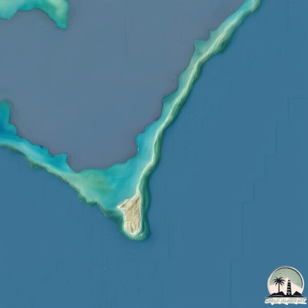
Geography and size of Motulak
Size: 1.459 km²
Coastline: 17.4 km
Ocean: Pacific Ocean
Sea: South Pacific Ocean
Continent: Oceania
Motulak is a Small Island spanning 1.5 km² with a coastline of 17.4 km.
Archipel: Polynesia – A region of more than 1,000 islands in the central and southern Pacific Ocean, known for their diverse Polynesian cultures, stunning landscapes, and marine biodiversity.
Tectonic Plate: Somalia – A large tectonic plate covering the Horn of Africa and parts of the Indian Ocean, known for the East African Rift where it’s splitting away from the African Plate.
The geographic heart of the island is pinpointed at these coordinates:
Latitude: -8.05792381 / Longitude: 178.3806255
Climate and weather of Motulak
Climate Zone: Tropical
Climate Details: Tropical Rainforest Climate
Temperature: Hot
Climate Characteristics: This climate is typified by heavy rainfall throughout the year, high humidity, and consistently high temperatures, leading to lush rainforests and rich biodiversity. Seasonal temperature variations are minimal.
Topography and nature of Motulak
Timezone: UTC+12:00
Timezone places: Pacific/Auckland
Max. Elevation: -2 m
Mean Elevation: -5 m
Vegetation: Evergreen Needleleaf Forest
Tree Coverage: 81%
The mean elevation is -5 m. Remarkably, this unique island barely emerges above the sea level, showcasing nature’s fascinating interplay with the ocean. The island is characterized by Plains: Flat, low-lying lands characterized by a maximum elevation of up to 200 meters. On islands, plains are typically coastal lowlands or central flat areas.
Dominating Vegetation: Evergreen Needleleaf Forest
Dominated by evergreen coniferous trees such as pines and firs, which retain their needle-like leaves throughout the year. These forests are often found in cooler climates. Motulak has a tree cover of 81 %.
Vegetation: 4 vegetation zones – Diverse Island
Four distinct vegetation zones mark these islands as ecologically diverse. They might feature varied landscapes such as forests, beaches, grasslands, and rocky areas. Such diversity reflects the island’s complex ecological interactions and varied habitats, which can support a rich array of wildlife and plant species.
Infrastructure and Travelling to Motulak
Does the island have a public airport? no.
There is no public and scheduled airport on Motulak. The nearest airport is Funafuti International Airport, located 104 km away.
Does the island have a major port? no.
There are no major ports on Motulak. The closest major port is FUNAFUTI ATOLL, approximately 97 km away.
The mean population of Motulak is 0 per km². Motulak is Uninhabited. The island belongs to Tuvalu.
The name of the island resonates across different cultures and languages. Here is how it is known around the world: Arabic: نوكوفيتاو; German: Nukufetau; Spanish: Nukufetau; French: Nukufetau; Portuguese: Nukufetau; Russian: атолл Нукуфетау; Chinese: 努库费陶
Continuing your journey, Rotuma Island is the next notable island, situated merely km away.
Tuvalu is classified as Least developed region: Countries that exhibit the lowest indicators of socioeconomic development, with the lowest Human Development Index ratings. The level of income is Upper middle income.
News – Latest Updates and Headlines from Motulak
Stay informed with the most recent news and important headlines from Motulak. Here’s a roundup of the latest developments.
Please note: The data used here has been primarily extracted from satellite readings. Deviations from exact values may occur, particularly regarding the height of elevations and population density. Land area and coastline measurements refer to average values at mean high tide.