Welcome to Nalau, a Temperate island in the The Coastal Waters of Southeast Alaska and British Columbia, part of the majestic Pacific Ocean. This guide offers a comprehensive overview of what makes Nalau unique – from its geography and climate to its population, infrastructure, and beyond. Dive into the details:
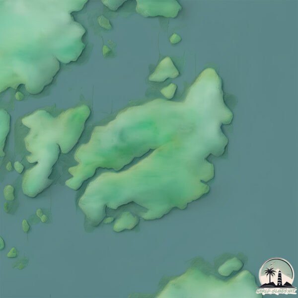
Geography and size of Nalau
Size: 13.4 km²
Coastline: 43.2 km
Ocean: Pacific Ocean
Sea: The Coastal Waters of Southeast Alaska and British Columbia
Continent: North America
Nalau is a Medium Island spanning 13 km² with a coastline of 43 km.
Archipel: –
Tectonic Plate: North America – Covers North America and parts of the Atlantic and Arctic Oceans, characterized by diverse geological features and varying levels of seismic activity.
The geographic heart of the island is pinpointed at these coordinates:
Latitude: 51.76833184 / Longitude: -128.02724066
Climate and weather of Nalau
Climate Zone: Temperate
Climate Details: Temperate Oceanic Climate
Temperature: Warm Summer
Climate Characteristics: Known for its moderate year-round temperatures with ample rainfall and no dry season. Warm summers are characteristic.
Topography and nature of Nalau
Timezone: UTC-08:00
Timezone places: America/Los_Angeles
Max. Elevation: 122 m
Mean Elevation: 64 m
Vegetation: Evergreen Needleleaf Forest
Tree Coverage: 75%
The mean elevation is 64 m. The highest elevation on the island reaches approximately 122 meters above sea level. The island is characterized by Plains: Flat, low-lying lands characterized by a maximum elevation of up to 200 meters. On islands, plains are typically coastal lowlands or central flat areas.
Dominating Vegetation: Evergreen Needleleaf Forest
Dominated by evergreen coniferous trees such as pines and firs, which retain their needle-like leaves throughout the year. These forests are often found in cooler climates. Nalau has a tree cover of 75 %.
Vegetation: 4 vegetation zones – Diverse Island
Four distinct vegetation zones mark these islands as ecologically diverse. They might feature varied landscapes such as forests, beaches, grasslands, and rocky areas. Such diversity reflects the island’s complex ecological interactions and varied habitats, which can support a rich array of wildlife and plant species.
Infrastructure and Travelling to Nalau
Does the island have a public airport? no.
There is no public and scheduled airport on Nalau. The nearest airport is Bella Bella (Campbell Island) Airport, located 46 km away.
Does the island have a major port? no.
There are no major ports on Nalau. The closest major port is BELLA BELLA, approximately 44 km away.
The mean population of Nalau is 0 per km². Nalau is Uninhabited. The island belongs to Canada.
Continuing your journey, Stirling is the next notable island, situated merely km away.
Namu, east Nalau Island
These videos are of a coastal aerial video imaging (AVI) survey conducted in the mid coast of British Columbia during 1997 from ...Namu, east Nalau Island
These videos are of a coastal aerial video imaging (AVI) survey ...
These videos are of a coastal aerial video imaging (AVI) survey conducted in the mid coast of British Columbia during 1997 from ...
West Nalau Island, Stirling Island, Breaker Group, Southwest Hunter Island
These videos are of a coastal aerial video imaging (AVI) survey ...
These videos are of a coastal aerial video imaging (AVI) survey conducted in the mid coast of British Columbia during 1997 from ...
Noel Nasup Nalau walking to Iatakwei village, Tanna Island
Noel Nasup Nalau Language: Nafé (Kwamera) Location: Iatakwei village, ...
Noel Nasup Nalau Language: Nafé (Kwamera) Location: Iatakwei village, Tanna island, Vanuatu Filmed by K. David Harrison ...
Canada
There is an island in Canada that is home to more bears than people. ...
There is an island in Canada that is home to more bears than people. Hunter Island, located in British Columbia, is famous for its ...
Approaching Nalau Passage
Views of the ocean swells on the approach to Nalau Passage, near Bella ...
Views of the ocean swells on the approach to Nalau Passage, near Bella Bella, British Columbia. For the full story, see "Going ...
VANUATU—Noel Nasup Nalau narrative in Nafé language on Tanna island
Noel Nasup Nalau shares a story in Nafé language Language: Nafé ...
Noel Nasup Nalau shares a story in Nafé language Language: Nafé (Kwamera) Location: Iatakwei village, Tanna island, Vanuatu ...
Swimming across the Burke Channel - Exit
After 6 hours and 45 minutes of swimming down Fisher Channel from ...
After 6 hours and 45 minutes of swimming down Fisher Channel from across Lama Pass, and across the Burke Chanel I was able ...
Sailing back to Vancouver Island from Bella Coola and close my 1700 km bikepacking loop
Join us on an unforgettable sunrise sailing from Bella Coola, as we ...
Join us on an unforgettable sunrise sailing from Bella Coola, as we cruise through the calm waters and get up close and personal ...
Spill Channel, Yeo Island
These videos are of a coastal aerial video imaging (AVI) survey ...
These videos are of a coastal aerial video imaging (AVI) survey conducted in the mid coast of British Columbia during 1997 from ...
North Dean Channel, King Island, Burke Channel
These videos are of a coastal aerial video imaging (AVI) survey ...
These videos are of a coastal aerial video imaging (AVI) survey conducted in the mid coast of British Columbia during 1997 from ...
Johnson Channel, Roscoe Inlet, Briggs Inlet, Spiller Inlet
These videos are of a coastal aerial video imaging (AVI) survey ...
These videos are of a coastal aerial video imaging (AVI) survey conducted in the mid coast of British Columbia during 1997 from ...
Hunter Island Mapping - Sample Video
Hakai Institute UAV Mapping on Hunter Island Hauyat - Hunter Island - ...
Hakai Institute UAV Mapping on Hunter Island Hauyat - Hunter Island - Central Coast - British Columbia - Canada Full video to ...
VANUATU—Nasip Nalau and Gregoire Maasi making rope at Iatukwei village, Tanna Island
video by K. David Harrison funded by NSF #nsffunded MVI 3978.
video by K. David Harrison funded by NSF #nsffunded MVI 3978.
VANUATU—Noel Nasup Nalau interview in Nafé language at Iatakwei, Tanna island
Noel Nasup Nalau Language: Nafé (Kwamera) Location: Iatakwei village, ...
Noel Nasup Nalau Language: Nafé (Kwamera) Location: Iatakwei village, Tanna island, Vanuatu Filmed by K. David Harrison ...
Burke Channel, south Bentick Arm
These videos are of a coastal aerial video imaging (AVI) survey ...
These videos are of a coastal aerial video imaging (AVI) survey conducted in the mid coast of British Columbia during 1997 from ...
Great Bear Rainforest & Sailing in the Fjords of Bella Coola
Dutch family sailing the Burke Channel in the Great Bear Rainforest.
Dutch family sailing the Burke Channel in the Great Bear Rainforest.
VANUATU—Sam Nato on Nafé culture school at Iatakwei, on Tanna island ( 2/2 )
Sam Nato (accompanied by Nasup Nalau) talks about the importance of ...
Sam Nato (accompanied by Nasup Nalau) talks about the importance of preserving Nafé cultural customs for longevity. On Tanna ...
Pacific White-Sided Dolphins in the wake of BC Ferries’ Northern Sea Wolf
Got to these amazing White-Sided Pacific Dolphins playing in the wake ...
Got to these amazing White-Sided Pacific Dolphins playing in the wake of BC Ferries' Northern Sea Wolf, in Burke Channel, south ...
Tanna Island, Gregoire Maasi sounds a tamtam.
On Tanna Island, Gregoire Maasi (speaker of Nafe language) sounds a ...
On Tanna Island, Gregoire Maasi (speaker of Nafe language) sounds a tamtam located along the pathway leading from the ...
Great Bear Swim: Fisher Channel to the Burke
A bit of raw footage from my Great Bear Swim this year down Fisher ...
A bit of raw footage from my Great Bear Swim this year down Fisher Channel toward the Burke. Conditions were fabulous for the ...
Tanna Island Vanuatu
I stood on the edge of core of the earth on the rim of exploding Mt Yasur!!
I stood on the edge of core of the earth on the rim of exploding Mt Yasur!!
Tanna island Vanuatu Coffee.mpg
A short story on the Coffee Industry 2012 Tanna Island, Vanuatu.
A short story on the Coffee Industry 2012 Tanna Island, Vanuatu.
Mathieson Channel, Finlayson Channel
These videos are of a coastal aerial video imaging (AVI) survey ...
These videos are of a coastal aerial video imaging (AVI) survey conducted in the mid coast of British Columbia during 1997 from ...
kulu Nabamu
Nunu Playlist.
Nunu Playlist.
EP10 - Argonaut Retraces History in Ocean Falls, Bella Coola
In this episode, Argonaut retraces history by visiting Ocean Falls, ...
In this episode, Argonaut retraces history by visiting Ocean Falls, where she was based as a mission boat from 1937 to 1966.
Canada is classified as Developed region: G7: Group of Seven – Major advanced economies, including Canada, France, Germany, Italy, Japan, the United Kingdom, and the United States. The level of income is High income: OECD.
News – Latest Updates and Headlines from Nalau
Stay informed with the most recent news and important headlines from Nalau. Here’s a roundup of the latest developments.
Loading...
Please note: The data used here has been primarily extracted from satellite readings. Deviations from exact values may occur, particularly regarding the height of elevations and population density. Land area and coastline measurements refer to average values at mean high tide.