Nautica
Welcome to Nautica, a Tropical island in the Laccadive Sea, part of the majestic Indian Ocean. This guide offers a comprehensive overview of what makes Nautica unique – from its geography and climate to its population, infrastructure, and beyond. Dive into the details:
- Geography and Size: Explore the island’s size and location.
- Climate and Weather: Weather patterns and temperature.
- Topography and Nature: Uncover the natural wonders of the island.
- Infrastructure and Travelling: Insights on reaching, staying, and making the most of your visit.
- News and Headlines: Latest News.
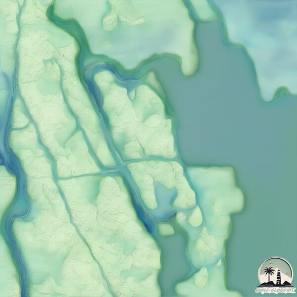
Geography and size of Nautica
Size: 1.069 km²
Coastline: 6.9 km
Ocean: Indian Ocean
Sea: Laccadive Sea
Continent: Asia
Nautica is a Small Island spanning 1.1 km² with a coastline of 6.9 km.
Archipel: –
Tectonic Plate: India – A major tectonic plate that initially moved northward at a rapid pace before colliding with the Eurasian Plate. This collision is responsible for the uplift of the Himalayas and the Tibetan Plateau.
The geographic heart of the island is pinpointed at these coordinates:
Latitude: 9.90611829 / Longitude: 76.3314773
Climate and weather of Nautica
Climate Zone: Tropical
Climate Details: Tropical Monsoon Climate
Temperature: Hot
Climate Characteristics: Characterized by heavy rainfall, high humidity, and uniformly high temperatures, but with a distinct short dry season. It features a seasonal reversal of prevailing wind directions.
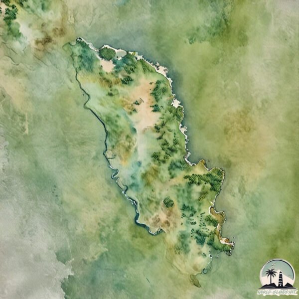
Topography and nature of Nautica
Timezone: UTC+05:30
Timezone places: Asia/Kolkata
Max. Elevation: 8 m
Mean Elevation: 6 m
Vegetation: Cultivated Land
Tree Coverage: 40%
The mean elevation is 6 m. The highest elevation on the island reaches approximately 8 meters above sea level. The island is characterized by Plains: Flat, low-lying lands characterized by a maximum elevation of up to 200 meters. On islands, plains are typically coastal lowlands or central flat areas.
Dominating Vegetation: Cultivated Land
Areas dedicated to agricultural activities, growing crops like grains, vegetables, and fruits. These lands are usually human-modified landscapes. Nautica has a tree cover of 40 %.
Vegetation: 3 vegetation zones – Moderately Diverse Island
These islands start to show a broader range of ecological niches. With three vegetation zones, they may offer a mix of ecosystems like coastal areas, inland woods, and perhaps a distinct wetland or dry area. This diversity supports a wider range of flora and fauna, making these islands more ecologically complex than those with minimal diversity.
Infrastructure and Travelling to Nautica
Does the island have a public airport? no.
There is no public and scheduled airport on Nautica. The nearest airport is Cochin International Airport, located 28 km away.
Does the island have a major port? no.
There are no major ports on Nautica. The closest major port is KOCHI (COCHIN), approximately 12 km away.
The mean population of Nautica is 3236 per km². Nautica is Densely Populated. The island belongs to India.
Continuing your journey, Vypīn Island is the next notable island, situated merely km away.
Inside Villa Nautica: The Maldives’ Hidden Gem Revealed!


India is classified as Emerging region: BRIC: Brazil, Russia, India, and China – Economies noted for their rapid growth and increasing influence on global affairs. The level of income is Lower middle income.
News – Latest Updates and Headlines from Nautica
Stay informed with the most recent news and important headlines from Nautica. Here’s a roundup of the latest developments.
Please note: The data used here has been primarily extracted from satellite readings. Deviations from exact values may occur, particularly regarding the height of elevations and population density. Land area and coastline measurements refer to average values at mean high tide.