Navutu-I-Ra Island

Welcome to Navutu-I-Ra Island, a Tropical island in the South Pacific Ocean, part of the majestic Pacific Ocean. This guide offers a comprehensive overview of what makes Navutu-I-Ra Island unique – from its geography and climate to its population, infrastructure, and beyond. Dive into the details:
- Geography and Size: Explore the island’s size and location.
- Climate and Weather: Weather patterns and temperature.
- Topography and Nature: Uncover the natural wonders of the island.
- Infrastructure and Travelling: Insights on reaching, staying, and making the most of your visit.
- News and Headlines: Latest News.
Geography and size of Navutu-I-Ra Island
Size: 0.811 km²
Coastline: 3.9 km
Ocean: Pacific Ocean
Sea: South Pacific Ocean
Continent: Oceania
Navutu-I-Ra Island is a Tiny Island spanning 0.811 km² with a coastline of 3.9 km.
Archipel: Fiji – Fiji, an archipelago in the South Pacific Ocean, is composed of more than 300 islands and is famed for its stunning coral reefs, beautiful tropical beaches, and rich cultural heritage. It’s a popular tourist destination, offering a range of activities from snorkeling to exploring traditional Fijian villages. Fiji’s diverse population has created a unique blend of indigenous, Indian, Chinese, and European cultures.
Tectonic Plate: Australia – A major tectonic plate covering Australia, New Zealand, and parts of the Indian and Pacific Oceans, known for its relative stability and occasional seismic activity.
The geographic heart of the island is pinpointed at these coordinates:
Latitude: -18.92298503 / Longitude: -178.52343072
Climate and weather of Navutu-I-Ra Island
Climate Zone: Tropical
Climate Details: Tropical Rainforest Climate
Temperature: Hot
Climate Characteristics: This climate is typified by heavy rainfall throughout the year, high humidity, and consistently high temperatures, leading to lush rainforests and rich biodiversity. Seasonal temperature variations are minimal.
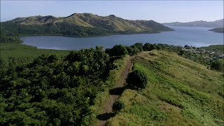
Topography and nature of Navutu-I-Ra Island
Timezone: UTC+12:00
Timezone places: Pacific/Auckland
Max. Elevation: 19 m
Mean Elevation: 8 m
Vegetation: Open Woodland
Tree Coverage: 26%
The mean elevation is 8 m. The highest elevation on the island reaches approximately 19 meters above sea level. The island is characterized by Plains: Flat, low-lying lands characterized by a maximum elevation of up to 200 meters. On islands, plains are typically coastal lowlands or central flat areas.
Dominating Vegetation: Open Woodland
Characterized by sparsely distributed trees with open canopy allowing sunlight to penetrate, supporting grasses and shrubs underneath. Often found in drier or transitional environments. Navutu-I-Ra Island has a tree cover of 26 %.
Vegetation: 3 vegetation zones – Moderately Diverse Island
These islands start to show a broader range of ecological niches. With three vegetation zones, they may offer a mix of ecosystems like coastal areas, inland woods, and perhaps a distinct wetland or dry area. This diversity supports a wider range of flora and fauna, making these islands more ecologically complex than those with minimal diversity.
Infrastructure and Travelling to Navutu-I-Ra Island
Does the island have a public airport? no.
There is no public and scheduled airport on Navutu-I-Ra Island. The nearest airport is Lakeba Island Airport, located 86 km away.
Does the island have a major port? no.
There are no major ports on Navutu-I-Ra Island. The closest major port is NUKU ALOFA, approximately 443 km away.
The mean population of Navutu-I-Ra Island is 19 per km². Navutu-I-Ra Island is Gently Populated. The island belongs to Fiji.
Continuing your journey, Namuka-I-Lau Island is the next notable island, situated merely km away.
Vale Ni Navutu


![Ono Na Maile - Kabani [Classics Mixdown]](https://i.ytimg.com/vi/gF_QHBQNH10/mqdefault.jpg)


Fiji is classified as Developing region: Regions characterized by lower income levels, with economies in the process of industrialization and modernization. The level of income is Lower middle income.
News – Latest Updates and Headlines from Navutu-I-Ra Island
Stay informed with the most recent news and important headlines from Navutu-I-Ra Island. Here’s a roundup of the latest developments.
Please note: The data used here has been primarily extracted from satellite readings. Deviations from exact values may occur, particularly regarding the height of elevations and population density. Land area and coastline measurements refer to average values at mean high tide.