Negros
Welcome to Negros, a Tropical island in the Sulu Sea, part of the majestic Pacific Ocean. This guide offers a comprehensive overview of what makes Negros unique – from its geography and climate to its population, infrastructure, and beyond. Dive into the details:
- Geography and Size: Explore the island’s size and location.
- Climate and Weather: Weather patterns and temperature.
- Topography and Nature: Uncover the natural wonders of the island.
- Infrastructure and Travelling: Insights on reaching, staying, and making the most of your visit.
- News and Headlines: Latest News.
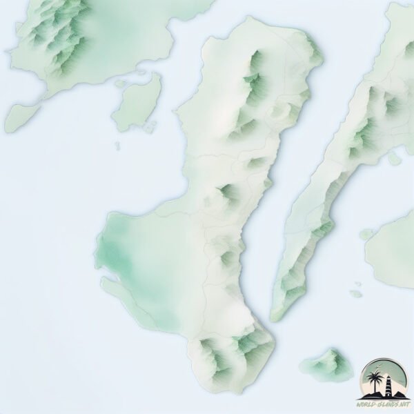
Geography and size of Negros
Size: 12850 km²
Coastline: 1011 km
Ocean: Pacific Ocean
Sea: Sulu Sea
Continent: Asia
Negros is a Giant Island spanning 12850 km² with a coastline of 1011 km.
Archipel: Malay Archipelago – The world’s largest archipelago, located between mainland Southeast Asia and Australia, known for its immense biodiversity and cultural diversity.
Tectonic Plate: Sunda – Extends across Southeast Asia, encompassing parts of the Sunda Shelf, known for its interaction with the Australian Plate, contributing to volcanic activity in Indonesia.
The geographic heart of the island is pinpointed at these coordinates:
Latitude: 10.02827951 / Longitude: 123.00548718
Climate and weather of Negros
Climate Zone: Tropical
Climate Details: Tropical Rainforest Climate
Temperature: Hot
Climate Characteristics: This climate is typified by heavy rainfall throughout the year, high humidity, and consistently high temperatures, leading to lush rainforests and rich biodiversity. Seasonal temperature variations are minimal.
Topography and nature of Negros
Timezone: UTC+08:00
Timezone places: Australia/Perth
Max. Elevation: 2430 m Canlaon Mtn.
Mean Elevation: 287 m
Vegetation: Agricultural Mosaic
Tree Coverage: 27%
The mean elevation is 287 m. Dominating the island’s landscape, the majestic “Canlaon Mtn.” rises as the highest peak, soaring to impressive heights. The island is characterized by Plateau: Elevated flatlands rising sharply above the surrounding area, with a maximum elevation over 500 meters but a mean elevation less than 300 meters, forming unique highland areas on islands.
Dominating Vegetation: Agricultural Mosaic
A mix of cropland and natural vegetation, often seen in rural landscapes where agricultural fields are interspersed with patches of natural habitats. Negros has a tree cover of 27 %.
Vegetation: 15 vegetation zones – Exceptionally Diverse Island
Islands with more than ten vegetation zones are among the most ecologically rich and varied in the world. These islands are akin to miniature continents, boasting an incredible array of ecosystems. The sheer range of habitats, from high peaks to deep valleys, rainforests to deserts, creates a mosaic of life that is unparalleled. They are crucial for conservation and ecological studies.
Infrastructure and Travelling to Negros
Does the island have a public airport? yes.
Negros has a public and scheduled airport. The following airports are located on this island: Bacolod-Silay Airport, Sibulan Airport.
Does the island have a major port? yes.
Negros is home to a major port. The following ports are situated on the island: SAN CARLOS, BAIS, DUMAGUETE, PULUPANDAN.
The mean population of Negros is 356 per km². Negros is Moderately Inhabited. The island belongs to Philippines.
The name of the island resonates across different cultures and languages. Here is how it is known around the world: Arabic: نيغروس; German: Negros; Spanish: Negros; French: Negros; Portuguese: Negros; Russian: Негрос; Chinese: 内格罗斯岛
Continuing your journey, Tagubanhan is the next notable island, situated merely km away.
10 Amazing Facts About Negros Island, Philippines


Philippines is classified as Emerging region: G20: Group of Twenty – Major economies comprising both developed and emerging countries, representing the world’s largest economies. The level of income is Lower middle income.
News – Latest Updates and Headlines from Negros
Stay informed with the most recent news and important headlines from Negros. Here’s a roundup of the latest developments.
Social Media Posts about Negros
Please note: The data used here has been primarily extracted from satellite readings. Deviations from exact values may occur, particularly regarding the height of elevations and population density. Land area and coastline measurements refer to average values at mean high tide.