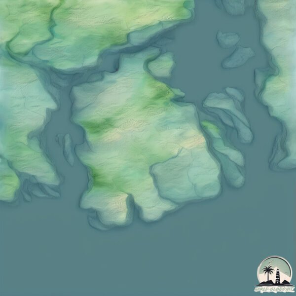
Welcome to Nesoyna, a Temperate island in the Norwegian Sea, part of the majestic Arctic Ocean. This guide offers a comprehensive overview of what makes Nesoyna unique – from its geography and climate to its population, infrastructure, and beyond. Dive into the details:
Geography and size of Nesoyna
Size: 6.553 km²
Coastline: 17 km
Ocean: Arctic Ocean
Sea: Norwegian Sea
Continent: Europe
Nesoyna is a Small Island spanning 6.6 km² with a coastline of 17 km.
Archipel: –
Tectonic Plate: Eurasia – One of the world’s largest tectonic plates, the Eurasian Plate covers a significant portion of Europe and Asia. It’s characterized by diverse geological features, including the Ural Mountains, the European Plain, and the Himalayas formed from its collision with the Indian Plate.
The geographic heart of the island is pinpointed at these coordinates:
Latitude: 61.05870394 / Longitude: 4.88581539
Climate and weather of Nesoyna
Climate Zone: Temperate
Climate Details: Temperate Oceanic Climate
Temperature: Warm Summer
Climate Characteristics: Known for its moderate year-round temperatures with ample rainfall and no dry season. Warm summers are characteristic.
Topography and nature of Nesoyna
Timezone: UTC+01:00
Timezone places: Europe/Paris
Max. Elevation: 173 m
Mean Elevation: 87 m
Vegetation: Open Woodland
Tree Coverage: 58%
The mean elevation is 87 m. The highest elevation on the island reaches approximately 173 meters above sea level. The island is characterized by Plains: Flat, low-lying lands characterized by a maximum elevation of up to 200 meters. On islands, plains are typically coastal lowlands or central flat areas.
Dominating Vegetation: Open Woodland
Characterized by sparsely distributed trees with open canopy allowing sunlight to penetrate, supporting grasses and shrubs underneath. Often found in drier or transitional environments. Nesoyna has a tree cover of 58 %.
Vegetation: 6 vegetation zones – Very Highly Diverse Island
Islands in this range are ecological powerhouses, showcasing a wide array of vegetation zones. Each zone, from lush rainforests to arid scrublands, coastal mangroves to mountainous regions, contributes to a complex and interdependent ecosystem. These islands are often hotspots of biodiversity, supporting numerous species and intricate ecological processes.
Infrastructure and Travelling to Nesoyna
Does the island have a public airport? no.
There is no public and scheduled airport on Nesoyna. The nearest airport is Florø Airport, located 58 km away.
Does the island have a major port? no.
There are no major ports on Nesoyna. The closest major port is MONGSTAD, approximately 29 km away.
The mean population of Nesoyna is 4 per km². Nesoyna is Gently Populated. The island belongs to Norway.
Continuing your journey, Sula is the next notable island, situated merely km away.
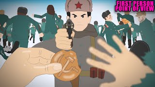
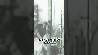
Nazinsky: Stalin’s Cannibal Island
In the middle of the Ob River in Siberia lies a forgotten island. Never officially named, it's known after the nearest village: the ...Nazinsky: Stalin’s Cannibal Island
In the middle of the Ob River in Siberia lies a forgotten island. ...
In the middle of the Ob River in Siberia lies a forgotten island. Never officially named, it's known after the nearest village: the ...
Never Visit This Island…
Would you visit the North Sentinel Island? All credit goes to the ...
Would you visit the North Sentinel Island? All credit goes to the original creator: @nelkfilmz Join this channel to get access to ...
Nazino Stalin’s Cannibal Island of Despair
In 1933, thousands were deported to Nazino Island without food or ...
In 1933, thousands were deported to Nazino Island without food or shelter. Within weeks, violence, starvation, and cannibalism ...
Nazino Island: Exile, Starvation, and Cannibalism under Stalin I SLICE HISTORY | FULL DOCUMENTARY
In the 1930's a great famine struck the Soviet Union and prompted a ...
In the 1930's a great famine struck the Soviet Union and prompted a vast exodus: in two years, more than ten million people left ...
Nazino Island, Stalin’s worst gulag camp #history
The Nazino Tragedy (or Nazino Affair) was a catastrophic and brief ...
The Nazino Tragedy (or Nazino Affair) was a catastrophic and brief episode of mass death and cannibalism that occurred in the ...
The Tragedy of Nazino Island (1933) #history #historytime #stories #animation #historytok
Real Cannibal Island: The Dark Tale of Nazino
Real Cannibal Island: The Dark Tale of Nazino Description: Discover ...
Real Cannibal Island: The Dark Tale of Nazino Description: Discover the harrowing history of Nazino Island, also known as ...
The most DISTURBING Photo of All - The Michael Rockefeller Case
This man is called Michael Rockefeller and he's heir to the powerful ...
This man is called Michael Rockefeller and he's heir to the powerful Rockefeller family. After his boat sank near an island in 1961, ...
The Real Battle Royale - Nazino Island Tragedy (1933)
Nazino: The Horror of Stalin’s Cannibal Island | FULL DOCUMENTARY
In the 1930's a great famine struck the Soviet Union and prompted a ...
In the 1930's a great famine struck the Soviet Union and prompted a vast exodus: in two years, more than ten million people left ...
MC BBO - NAZINO ISLAND -
MC BBO Prod. MADROCK Album: ULTIMO ANNO DI LUCE ...
The Forgotten Horror of Nazino Island #stalin #NazinoIsland #SovietHistory #HumanSurvival #history
Discover the harrowing tale of Nazino Island, where thousands of ...
Discover the harrowing tale of Nazino Island, where thousands of 'undesirables' were forcibly relocated by Soviet authorities.
The Most Disturbing Island in History.
In 1933, thousands were exiled to Nazino Island, where starvation bred ...
In 1933, thousands were exiled to Nazino Island, where starvation bred violence and cannibalism. Discover the chilling Soviet ...
The Most Infamous Settlement, Nazino Island
Shorts In an attempt to turn Siberia into something more productive, ...
Shorts In an attempt to turn Siberia into something more productive, the Soviet Union created forced settlements in the tundra ...
Nazino Island: Stalin’s Experiment That Went Horribly Wrong #history #shorts #historicalfacts
In 1933, Soviet Russia exiled over 6000 people to a remote island in ...
In 1933, Soviet Russia exiled over 6000 people to a remote island in Siberia, promising them a fresh start. Instead, they found no ...
The fate of the 6000 “unwanted” under Stalin I History Calls | FULL DOCUMENTARY
In the 1930's a great famine struck the Soviet Union and prompted a ...
In the 1930's a great famine struck the Soviet Union and prompted a vast exodus: in two years, more than ten million people left ...
Nazino Island: Cannibal Island — When Survival Turned Human into Monsters
Nazino Island: Cannibal Island — When Survival Turned Human into ...
Nazino Island: Cannibal Island — When Survival Turned Human into Monsters #Shorts.
Stalin’s Cannibal Island: The Soviet Death Camp No One Survived
Stalin's Cannibal Island: The Soviet Death Camp No One Survived In May ...
Stalin's Cannibal Island: The Soviet Death Camp No One Survived In May 1933, deep within the Siberian wilderness, Nazino ...
Exploring the Dark Secrets of the World's Most Forbidden Island!
No matter where your next adventure takes you, Manta Sleep helps you ...
No matter where your next adventure takes you, Manta Sleep helps you get the rest you need to keep exploring. Grab yours here: ...
Tautog and seal off Naushon island
La tragedia de Nazino: deportados al infierno siberiano | SLICE Iberia | DOCUMENTAL COMPLETO
En la década de 1930, una gran hambruna golpeó la Unión Soviética y ...
En la década de 1930, una gran hambruna golpeó la Unión Soviética y provocó un éxodo masivo: en solo dos años, más de diez ...
Nazino Island's Terrifying History Unveiled
In 1933, during the era of Soviet repression under Joseph Stalin, over ...
In 1933, during the era of Soviet repression under Joseph Stalin, over 6000 people were forcibly deported to the remote Siberian ...
How You Survived the Real Battle Royale in History - Nazino Island (1933)
Join the battle in Rise of Kingdoms today! ...
Cannibal Island: Inside Siberia’s 1933 Nazino Island #history #truehistory #terrifyingtales #horror
Nazino Island—better known as Cannibal Island—was Stalin's forgotten ...
Nazino Island—better known as Cannibal Island—was Stalin's forgotten 1933 Gulag experiment where 6700 deportees were ...
Norway is classified as Developed region: nonG7: Developed economies outside of the Group of Seven, characterized by high income and advanced economic structures. The level of income is High income: OECD.
News – Latest Updates and Headlines from Nesoyna
Stay informed with the most recent news and important headlines from Nesoyna. Here’s a roundup of the latest developments.
Loading...
Please note: The data used here has been primarily extracted from satellite readings. Deviations from exact values may occur, particularly regarding the height of elevations and population density. Land area and coastline measurements refer to average values at mean high tide.