Nijhum Dwip
Welcome to Nijhum Dwip, a Tropical island in the Bay of Bengal, part of the majestic Indian Ocean. This guide offers a comprehensive overview of what makes Nijhum Dwip unique – from its geography and climate to its population, infrastructure, and beyond. Dive into the details:
- Geography and Size: Explore the island’s size and location.
- Climate and Weather: Weather patterns and temperature.
- Topography and Nature: Uncover the natural wonders of the island.
- Infrastructure and Travelling: Insights on reaching, staying, and making the most of your visit.
- News and Headlines: Latest News.
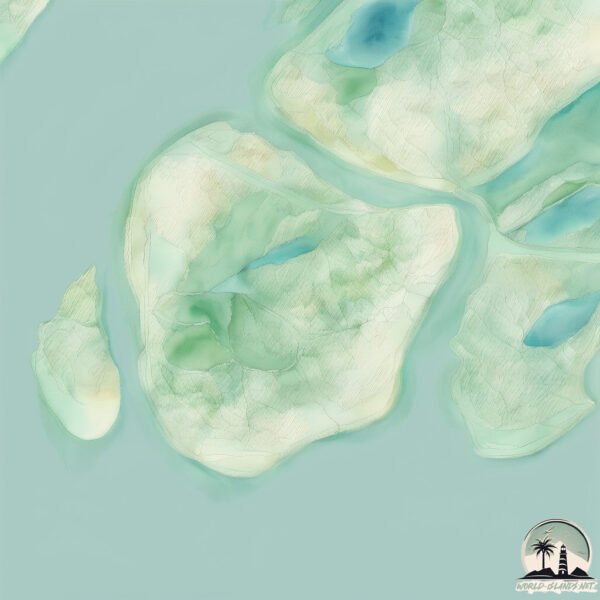
Geography and size of Nijhum Dwip
Size: 49.7 km²
Coastline: 31.9 km
Ocean: Indian Ocean
Sea: Bay of Bengal
Continent: Asia
Nijhum Dwip is a Medium Island spanning 50 km² with a coastline of 32 km.
Archipel: –
Tectonic Plate: India – A major tectonic plate that initially moved northward at a rapid pace before colliding with the Eurasian Plate. This collision is responsible for the uplift of the Himalayas and the Tibetan Plateau.
The geographic heart of the island is pinpointed at these coordinates:
Latitude: 22.06301364 / Longitude: 91.00439744
Climate and weather of Nijhum Dwip
Climate Zone: Tropical
Climate Details: Tropical Monsoon Climate
Temperature: Hot
Climate Characteristics: Characterized by heavy rainfall, high humidity, and uniformly high temperatures, but with a distinct short dry season. It features a seasonal reversal of prevailing wind directions.
Topography and nature of Nijhum Dwip
Timezone: UTC+06:00
Timezone places: Asia/Dhaka
Max. Elevation: 12 m
Mean Elevation: 3 m
Vegetation: Agricultural Mosaic
Tree Coverage: 56%
The mean elevation is 3 m. The highest elevation on the island reaches approximately 12 meters above sea level. The island is characterized by Plains: Flat, low-lying lands characterized by a maximum elevation of up to 200 meters. On islands, plains are typically coastal lowlands or central flat areas.
Dominating Vegetation: Agricultural Mosaic
A mix of cropland and natural vegetation, often seen in rural landscapes where agricultural fields are interspersed with patches of natural habitats. Nijhum Dwip has a tree cover of 56 %.
Vegetation: 14 vegetation zones – Exceptionally Diverse Island
Islands with more than ten vegetation zones are among the most ecologically rich and varied in the world. These islands are akin to miniature continents, boasting an incredible array of ecosystems. The sheer range of habitats, from high peaks to deep valleys, rainforests to deserts, creates a mosaic of life that is unparalleled. They are crucial for conservation and ecological studies.
Infrastructure and Travelling to Nijhum Dwip
Does the island have a public airport? no.
There is no public and scheduled airport on Nijhum Dwip. The nearest airport is Shah Amanat International Airport, located 87 km away.
Does the island have a major port? no.
There are no major ports on Nijhum Dwip. The closest major port is CHITTAGONG, approximately 89 km away.
The mean population of Nijhum Dwip is 919 per km². Nijhum Dwip is Densely Populated. The island belongs to Bangladesh.
Continuing your journey, Domar Char is the next notable island, situated merely km away.
নিঝুম দ্বীপ : বঙ্গোপসাগরে জেগে উঠা আরেক সুন্দরবন !! Nijhum Dwip, Most beautiful island in Bangladesh


Bangladesh is classified as Least developed region: Countries that exhibit the lowest indicators of socioeconomic development, with the lowest Human Development Index ratings. The level of income is Low income.
News – Latest Updates and Headlines from Nijhum Dwip
Stay informed with the most recent news and important headlines from Nijhum Dwip. Here’s a roundup of the latest developments.
Please note: The data used here has been primarily extracted from satellite readings. Deviations from exact values may occur, particularly regarding the height of elevations and population density. Land area and coastline measurements refer to average values at mean high tide.