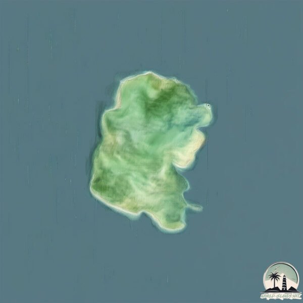
Welcome to Nisída Arkoúdi, a Temperate island in the Ionian Sea, part of the majestic Atlantic Ocean. This guide offers a comprehensive overview of what makes Nisída Arkoúdi unique – from its geography and climate to its population, infrastructure, and beyond. Dive into the details:
Geography and size of Nisída Arkoúdi
Size: 4.314 km²
Coastline: 9.8 km
Ocean: Atlantic Ocean
Sea: Ionian Sea
Continent: Europe
Nisída Arkoúdi is a Small Island spanning 4.3 km² with a coastline of 9.8 km.
Archipel: Ionian Islands – A group of islands in the Ionian Sea, west of mainland Greece, known for their rich history, beautiful landscapes, and cultural heritage.
Tectonic Plate: Eurasia – One of the world’s largest tectonic plates, the Eurasian Plate covers a significant portion of Europe and Asia. It’s characterized by diverse geological features, including the Ural Mountains, the European Plain, and the Himalayas formed from its collision with the Indian Plate.
The geographic heart of the island is pinpointed at these coordinates:
Latitude: 38.55343961 / Longitude: 20.71034406
Climate and weather of Nisída Arkoúdi
Climate Zone: Temperate
Climate Details: Hot-Summer Mediterranean Climate
Temperature: Hot Summer
Climate Characteristics: Characterized by hot, dry summers and mild, wet winters, typical of coastal areas with abundant sunshine.
Topography and nature of Nisída Arkoúdi
Timezone: UTC+02:00
Timezone places: Europe/Mariehamn
Max. Elevation: 84 m
Mean Elevation: 57 m
Vegetation: Evergreen Broadleaf Forest
Tree Coverage: 48%
The mean elevation is 57 m. The highest elevation on the island reaches approximately 84 meters above sea level. The island is characterized by Plains: Flat, low-lying lands characterized by a maximum elevation of up to 200 meters. On islands, plains are typically coastal lowlands or central flat areas.
Dominating Vegetation: Evergreen Broadleaf Forest
Characterized by dense, lush canopies of broadleaf trees that retain their leaves year-round. These forests are typically found in tropical and subtropical regions and are known for their high biodiversity. Nisída Arkoúdi has a tree cover of 48 %.
Vegetation: 4 vegetation zones – Diverse Island
Four distinct vegetation zones mark these islands as ecologically diverse. They might feature varied landscapes such as forests, beaches, grasslands, and rocky areas. Such diversity reflects the island’s complex ecological interactions and varied habitats, which can support a rich array of wildlife and plant species.
Infrastructure and Travelling to Nisída Arkoúdi
Does the island have a public airport? no.
There is no public and scheduled airport on Nisída Arkoúdi. The nearest airport is Aktion National Airport, located 40 km away.
Does the island have a major port? no.
There are no major ports on Nisída Arkoúdi. The closest major port is PREVEZA, approximately 43 km away.
The mean population of Nisída Arkoúdi is 44 per km². Nisída Arkoúdi is Gently Populated. The island belongs to Greece.
Continuing your journey, Nisída Meganísi is the next notable island, situated merely km away.
10 Most Beautiful Dodecanese islands
This list is dedicated to Tripadvisor,Google Guides and Tourists MUST DO guide lists but also a private list of Travel Time Youtube ...10 Most Beautiful Dodecanese islands
This list is dedicated to Tripadvisor,Google Guides and Tourists MUST ...
This list is dedicated to Tripadvisor,Google Guides and Tourists MUST DO guide lists but also a private list of Travel Time Youtube ...
Donoussa Greece: The Enchantress of The Aegean Sea (Greek Islands)
Rhodos 🇬🇷 is the largest and the historical capital of the Dodecanese islands of Greece.
Explore the fascinating history of the world with our interactive map ...
Explore the fascinating history of the world with our interactive map videos! From ancient civilizations to modern nations, we bring ...
Escape to Donousa: Greece's Island Paradise 🏝️🌊✨#Donousa #Greece #GreekParadise #IslandEscape 🛫
Welcome to Aegean Voyager, where we showcase the beauty and wonder of ...
Welcome to Aegean Voyager, where we showcase the beauty and wonder of Greece, a country that boasts a rich history, ...
Let's Discover Rhodes, Symi and Kalymnos!🌴🇬🇷
Join DW's Sarah Hucal on a Greek island-hopping adventure! She shows ...
Join DW's Sarah Hucal on a Greek island-hopping adventure! She shows you the highlights on Rhodes, Symi, and Kalymnos in ...
The Dodecanese Islands: Greece's Cultural Heart
Escape to Greece's enchanting Dodecanese islands, where the sacred ...
Escape to Greece's enchanting Dodecanese islands, where the sacred aura of Patmos and the vibrant traditions of Kalimnos and ...
10 Dodecanese islands Greece 🇬🇷
This list is dedicated to Tripadvisor,Google Guides and Tourists MUST ...
This list is dedicated to Tripadvisor,Google Guides and Tourists MUST DO guide lists but also a private list of Travel Time Youtube ...
Donousa Travel Guide | Hidden Gem of the Cyclades (How to Get There, What to Do & More!)
Discover the enchanting Greek island of Donousa, one of the ...
Discover the enchanting Greek island of Donousa, one of the lesser-known jewels of the Cyclades! In this narrated travel guide, ...
The Greek Island Heaven of Donoussa | Greece Travel
Donoussa is a Greek island heaven with stunning beaches. Donoussa is a ...
Donoussa is a Greek island heaven with stunning beaches. Donoussa is a quiet Cycladic island east of Naxos and is the perfect ...
Nisyros Dodecanese Islands Greece | Sea TV Sailing Channel
Nisyros island is located about 8 miles southeast of Kos This round ...
Nisyros island is located about 8 miles southeast of Kos This round small island offers several attractions worth visiting: Rent a car ...
Leros Island Travel Video – Greece’s Hidden Gem - 4K UHD
Discovering Leros Island – Greece's Hidden Gem Welcome to Leros! In ...
Discovering Leros Island – Greece's Hidden Gem Welcome to Leros! In this video, I take you on a journey to one of Greece's ...
Tilos Dodecanese Islands Greece | Sea TV Sailing Channel
Tilos Dodecanese Islands Greece Tilos Island Lies between Nisyros and ...
Tilos Dodecanese Islands Greece Tilos Island Lies between Nisyros and Chalki. The island has a few stunning unspoiled bays ...
North Dodecanese Islands, Greece
Kos Dodecanese Islands - Greece
Kos third largest Dodecanese Island, place where Hippocrates was born ...
Kos third largest Dodecanese Island, place where Hippocrates was born and used to teach his knowledge.
✨ Koufonisia - Most Beautiful Greek Island? | Greece Travel 2025
Koufonisia Travel Guide 2025 No crowds. No chaos. Just next-level ...
Koufonisia Travel Guide 2025 No crowds. No chaos. Just next-level water, barefoot vibes & sunsets that'll ruin all other sunsets.
Two Weeks Sailing the Greek Dodecanese - Sailing Trip Inspiration
Join us as we explore the stunning northern Dodecanese islands in ...
Join us as we explore the stunning northern Dodecanese islands in Greece. We rented a sailboat in Kos and spent two ...
This Tiny Greek Island is a Dream | Donousa: Hikes, Beaches & Local Life
In this video, I explore Donousa, one of the smallest and most remote ...
In this video, I explore Donousa, one of the smallest and most remote islands in the Cyclades. Known for its quiet charm and ...
Top 10 QUIETEST Greek Islands
Tired of the overcrowded popular tourist destinations? Yearning for a ...
Tired of the overcrowded popular tourist destinations? Yearning for a serene escape where the whispers of the wind and the ...
Sailing Holidays, Greece: Dodecanese. 7 Islands: RHODOS, SYMI, TILOS, NISYROS, HALKI, ALIMIA
Your next escape starts here—watch now! Planning a sailing trip in the ...
Your next escape starts here—watch now! Planning a sailing trip in the Dodecanese? Our video is the perfect guide! We spent two ...
Unveiling the Dodecanese: A Week of Scenic Sailing Escape from Rhodes
...
Island Hopping the BEAUTIFUL Dodecanese 🇬🇷 Part 2 (Travel Documentary)
Episode 41 - Part 2: A Greek Island Adventure exploring the Dodecanese ...
Episode 41 - Part 2: A Greek Island Adventure exploring the Dodecanese Islands - Patmos to Samos. To get the music from this ...
Karpathos: The Untouched Beauty of the Dodecanese#karpathos #greece #facts
Ladies and gentlemen, welcome to Karpathos, a breathtaking island in ...
Ladies and gentlemen, welcome to Karpathos, a breathtaking island in the Dodecanese that remains one of Greece's best-kept ...
Island Hopping the BEAUTIFUL Dodecanese 🇬🇷 Part 1 (Travel Documentary)
Episode 40 - Part 1: A Greek Island Adventure exploring the Dodecanese ...
Episode 40 - Part 1: A Greek Island Adventure exploring the Dodecanese Islands - Kos to Kalymnos. Go to our sponsor ...
Top Greek Islands Near Athens for True Travelers
Escape the hustle of Athens and discover the serene beauty of the ...
Escape the hustle of Athens and discover the serene beauty of the Saronic Islands. In this episode of Hidden Greece, we explore ...
Kalymnos Island, Dodecanese, Greece | Sea TV Sailing Channel
Kalymnos Island, Dodecanese, Greece Kalymnos Island lies just south of ...
Kalymnos Island, Dodecanese, Greece Kalymnos Island lies just south of Leros. The town is bustling and popular and still imparts ...
Greece is classified as Developed region: nonG7: Developed economies outside of the Group of Seven, characterized by high income and advanced economic structures. The level of income is High income: OECD.
News – Latest Updates and Headlines from Nisída Arkoúdi
Stay informed with the most recent news and important headlines from Nisída Arkoúdi. Here’s a roundup of the latest developments.
Loading...
Please note: The data used here has been primarily extracted from satellite readings. Deviations from exact values may occur, particularly regarding the height of elevations and population density. Land area and coastline measurements refer to average values at mean high tide.