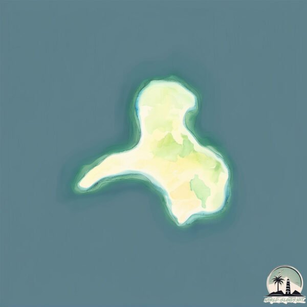
Welcome to Nisída Frágkos, a Temperate island in the Aegean Sea, part of the majestic Atlantic Ocean. This guide offers a comprehensive overview of what makes Nisída Frágkos unique – from its geography and climate to its population, infrastructure, and beyond. Dive into the details:
Geography and size of Nisída Frágkos
Size: 0.273 km²
Coastline: 2.7 km
Ocean: Atlantic Ocean
Sea: Aegean Sea
Continent: Europe
Nisída Frágkos is a Tiny Island spanning 0.273 km² with a coastline of 2.7 km.
Archipel: –
Tectonic Plate: Aegean Sea – Located in the eastern Mediterranean, this microplate is characterized by seismic and volcanic activity due to its interaction with the Eurasian and African Plates.
The geographic heart of the island is pinpointed at these coordinates:
Latitude: 37.25552012 / Longitude: 26.71861335
Climate and weather of Nisída Frágkos
Climate Zone: Temperate
Climate Details: Hot-Summer Mediterranean Climate
Temperature: Hot Summer
Climate Characteristics: Characterized by hot, dry summers and mild, wet winters, typical of coastal areas with abundant sunshine.
Topography and nature of Nisída Frágkos
Timezone: UTC+02:00
Timezone places: Europe/Mariehamn
Max. Elevation: -1 m
Mean Elevation: -7 m
Vegetation: Sparse Vegetation with Trees/Shrubs
Tree Coverage: 73%
The mean elevation is -7 m. Remarkably, this unique island barely emerges above the sea level, showcasing nature’s fascinating interplay with the ocean. The island is characterized by Plains: Flat, low-lying lands characterized by a maximum elevation of up to 200 meters. On islands, plains are typically coastal lowlands or central flat areas.
Dominating Vegetation: Sparse Vegetation with Trees/Shrubs
Areas where grasses and other herbaceous plants are prevalent, but with occasional presence of trees and shrubs. Often found in semi-arid regions or grasslands. Nisída Frágkos has a tree cover of 73 %.
Vegetation: 2 vegetation zones – Low Diversity Island
Islands with two distinct vegetation zones offer slightly more ecological variety. These zones could be due to differences in elevation, moisture, or other environmental factors. While still limited in biodiversity, these islands may offer a contrast between the two zones, such as a coastline with mangroves and an inland area with grassland.
Infrastructure and Travelling to Nisída Frágkos
Does the island have a public airport? no.
There is no public and scheduled airport on Nisída Frágkos. The nearest airport is Leros Airport, located 12 km away.
Does the island have a major port? no.
There are no major ports on Nisída Frágkos. The closest major port is LAKKI, approximately 20 km away.
The mean population of Nisída Frágkos is 44 per km². Nisída Frágkos is Gently Populated. The island belongs to Greece.
Continuing your journey, Nisí Leipsoí is the next notable island, situated merely km away.
Donoussa Greece: The Enchantress of The Aegean Sea (Greek Islands)
Donousa Travel Guide | Hidden Gem of the Cyclades (How to Get There, What to Do & More!)
Discover the enchanting Greek island of Donousa, one of the ...
Discover the enchanting Greek island of Donousa, one of the lesser-known jewels of the Cyclades! In this narrated travel guide, ...
Escape to Donousa: Greece's Island Paradise 🏝️🌊✨#Donousa #Greece #GreekParadise #IslandEscape 🛫
Welcome to Aegean Voyager, where we showcase the beauty and wonder of ...
Welcome to Aegean Voyager, where we showcase the beauty and wonder of Greece, a country that boasts a rich history, ...
The Greek Island Heaven of Donoussa | Greece Travel
Donoussa is a Greek island heaven with stunning beaches. Donoussa is a ...
Donoussa is a Greek island heaven with stunning beaches. Donoussa is a quiet Cycladic island east of Naxos and is the perfect ...
This Tiny Greek Island is a Dream | Donousa: Hikes, Beaches & Local Life
In this video, I explore Donousa, one of the smallest and most remote ...
In this video, I explore Donousa, one of the smallest and most remote islands in the Cyclades. Known for its quiet charm and ...
Top 10 QUIETEST Greek Islands
Tired of the overcrowded popular tourist destinations? Yearning for a ...
Tired of the overcrowded popular tourist destinations? Yearning for a serene escape where the whispers of the wind and the ...
✨ Koufonisia - Most Beautiful Greek Island? | Greece Travel 2025
Koufonisia Travel Guide 2025 No crowds. No chaos. Just next-level ...
Koufonisia Travel Guide 2025 No crowds. No chaos. Just next-level water, barefoot vibes & sunsets that'll ruin all other sunsets.
Topos Documentary | Donousa Island (Episode 1) - Voices of the Cyclades
'Τόπος' (Topos) is a documentary series by Eudaimonia Tourism, ...
'Τόπος' (Topos) is a documentary series by Eudaimonia Tourism, exploring the unspoken truths and interconnections of Greek ...
Top Greek Islands Near Athens for True Travelers
Escape the hustle of Athens and discover the serene beauty of the ...
Escape the hustle of Athens and discover the serene beauty of the Saronic Islands. In this episode of Hidden Greece, we explore ...
Plaka beach at Naxos island, Greece
One of the most beautiful beaches in Naxos, view more at ...
DONOUSA | Amazing Little Greek Island Near Naxos
Exploring the beautiful and mountainous little Greek island of ...
Exploring the beautiful and mountainous little Greek island of Donousa, one of the Lesser Cycladic islands near Naxos and ...
Donousa, Greece 4K | Walking Tour | A relaxing SubVLOG stroll across the Aegean island
Join me for a peaceful 9-minute walk through the hidden gem of ...
Join me for a peaceful 9-minute walk through the hidden gem of Donousa. In this video, I'll take you on a quiet stroll through the ...
Donoussa | A Submerged Poem from the Aegean Sea HD 1080p
Dopo quasi nove ore di traghetto da Atene, finalmente a Donoussa! Una ...
Dopo quasi nove ore di traghetto da Atene, finalmente a Donoussa! Una delle più piccole e remote isole delle Cicladi. Poco più di ...
A Tourist's Mini Video Guide For Donoussa Island
Maps showing hotels, restaurants, airport(s), sightseeing's, etc. ...
Maps showing hotels, restaurants, airport(s), sightseeing's, etc. Websites to book online your flying tickets and your hotels.
Greek Maldives: Donousa, a Bohemian island - top beaches and sights ~ Η μποέμ Δονούσα!
Donousa is a beautiful small island in the southeastern Cyclades, ...
Donousa is a beautiful small island in the southeastern Cyclades, situated 10 miles north of Amorgos and east of Naxos.
Donoussa
Donoussa è tutto ciò che serve per appagare il fisico e la mente. Chi ...
Donoussa è tutto ciò che serve per appagare il fisico e la mente. Chi sostiene che per vivere Donoussa bastano 3 giorni non ha ...
Discovering Greece's Hidden Gems | Small Cyclades Adventure
Embark on an extraordinary journey through the hidden treasures of ...
Embark on an extraordinary journey through the hidden treasures of Greece's enchanting Small Cyclades islands with our ...
Epic Adventures on the Greek Island of DONOUSA
Part 2 of my biking and hiking adventure on the small but very ...
Part 2 of my biking and hiking adventure on the small but very mountainous Greek island of Donousa. You can watch Part 1 here: ...
Donousa - Aegean Sea - Hellas-Greece
Donousa is a Greek Island that located in Aegean sea in ...
Donousa is a Greek Island that located in Aegean sea in Hellas-Greece.In this video we can see all the beauties of the island of ...
Δονουσσα #travel #greece #δονουσσα #donoussa #greece#beautifuldestinations #greecetravelguide #fypシ゚
Cyclades: Milos, Koufonissi, Donoussa
Milos, Donoussa, Koufonissi.
Milos, Donoussa, Koufonissi.
Topos Documentary | Donousa Island (Episode 2) - Voices of the Cyclades
'Τόπος' (Topos) is a documentary series by Eudaimonia Tourism, ...
'Τόπος' (Topos) is a documentary series by Eudaimonia Tourism, exploring the unspoken truths and interconnections of Greek ...
Δονουσάρα!
Η εμπειρία μου όπως την κατέγραψα στην αγαπημένη μου πλέον Δονούσα το ...
Η εμπειρία μου όπως την κατέγραψα στην αγαπημένη μου πλέον Δονούσα το καλοκαίρι του 2019. Ένα τόσο μικρό νησί που μπορεί ...
Antiparos - Donoussa 2020
Due to covid we tried an alternative way of traveling. It paid off ...
Due to covid we tried an alternative way of traveling. It paid off 100%. *Huge thanks to my dearest friend Eleni* #greekislands ...
Δονούσα HD - Σεπτέμβριος 2018 - Donousa island 2018
Εικόνες και βίντεο από την Δονούσα τη μάγισσα, όπως λέγεται και το ...
Εικόνες και βίντεο από την Δονούσα τη μάγισσα, όπως λέγεται και το καϊκι που μεταφέρει τους ταξιδιώτες στις παραλίες του νησιού.
Greece is classified as Developed region: nonG7: Developed economies outside of the Group of Seven, characterized by high income and advanced economic structures. The level of income is High income: OECD.
News – Latest Updates and Headlines from Nisída Frágkos
Stay informed with the most recent news and important headlines from Nisída Frágkos. Here’s a roundup of the latest developments.
Loading...
Please note: The data used here has been primarily extracted from satellite readings. Deviations from exact values may occur, particularly regarding the height of elevations and population density. Land area and coastline measurements refer to average values at mean high tide.