Nōmi Jima
Welcome to Nōmi Jima, a Temperate island in the Seto Naikai or Inland Sea, part of the majestic Pacific Ocean. This guide offers a comprehensive overview of what makes Nōmi Jima unique – from its geography and climate to its population, infrastructure, and beyond. Dive into the details:
- Geography and Size: Explore the island’s size and location.
- Climate and Weather: Weather patterns and temperature.
- Topography and Nature: Uncover the natural wonders of the island.
- Infrastructure and Travelling: Insights on reaching, staying, and making the most of your visit.
- News and Headlines: Latest News.
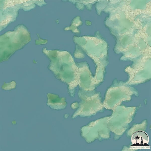
Geography and size of Nōmi Jima
Size: 94.4 km²
Coastline: 121.7 km
Ocean: Pacific Ocean
Sea: Seto Naikai or Inland Sea
Continent: Asia
Nōmi Jima is a Medium Island spanning 94 km² with a coastline of 122 km.
Archipel: Japan – An East Asian archipelago comprising four main islands and numerous smaller ones, known for its rich history, technological advances, and distinct culture.
Tectonic Plate: Eurasia – One of the world’s largest tectonic plates, the Eurasian Plate covers a significant portion of Europe and Asia. It’s characterized by diverse geological features, including the Ural Mountains, the European Plain, and the Himalayas formed from its collision with the Indian Plate.
The geographic heart of the island is pinpointed at these coordinates:
Latitude: 34.21822498 / Longitude: 132.44846907
Climate and weather of Nōmi Jima
Climate Zone: Temperate
Climate Details: Humid Subtropical Climate
Temperature: Hot Summer
Climate Characteristics: With continuous rainfall and hot summers, this climate is common in some coastal regions, supporting diverse vegetation.
Topography and nature of Nōmi Jima
Timezone: UTC+09:00
Timezone places: Asia/Tokyo
Max. Elevation: 374 m
Mean Elevation: 101 m
Vegetation: Evergreen Broadleaf Forest
Tree Coverage: 57%
The mean elevation is 101 m. The highest elevation on the island reaches approximately 374 meters above sea level. The island is characterized by Hills: Gently sloping landforms with rounded tops, having a maximum elevation between 200 and 500 meters. Hills contribute to a varied landscape on islands.
Dominating Vegetation: Evergreen Broadleaf Forest
Characterized by dense, lush canopies of broadleaf trees that retain their leaves year-round. These forests are typically found in tropical and subtropical regions and are known for their high biodiversity. Nōmi Jima has a tree cover of 57 %.
Vegetation: 10 vegetation zones – Very Highly Diverse Island
Islands in this range are ecological powerhouses, showcasing a wide array of vegetation zones. Each zone, from lush rainforests to arid scrublands, coastal mangroves to mountainous regions, contributes to a complex and interdependent ecosystem. These islands are often hotspots of biodiversity, supporting numerous species and intricate ecological processes.
Infrastructure and Travelling to Nōmi Jima
Does the island have a public airport? no.
There is no public and scheduled airport on Nōmi Jima. The nearest airport is Iwakuni Kintaikyo Airport / Marine Corps Air Station Iwakuni, located 18 km away.
Does the island have a major port? yes.
Nōmi Jima is home to a major port. The following ports are situated on the island: KANOKAWA KO.
The mean population of Nōmi Jima is 258 per km². Nōmi Jima is Moderately Inhabited. The island belongs to Japan.
The name of the island resonates across different cultures and languages. Here is how it is known around the world: Arabic: هونشو; Spanish: Honshū; French: Honshū; Portuguese: Honshu; Russian: Хонсю; Chinese: 本州
Continuing your journey, Itsuku Shima is the next notable island, situated merely km away.
20220417 Jetty in the Noumi Island 能美島大附 突堤


Japan is classified as Developed region: G7: Group of Seven – Major advanced economies, including Canada, France, Germany, Italy, Japan, the United Kingdom, and the United States. The level of income is High income: OECD.
News – Latest Updates and Headlines from Nōmi Jima
Stay informed with the most recent news and important headlines from Nōmi Jima. Here’s a roundup of the latest developments.
Please note: The data used here has been primarily extracted from satellite readings. Deviations from exact values may occur, particularly regarding the height of elevations and population density. Land area and coastline measurements refer to average values at mean high tide.