Welcome to Noonu, a Tropical island in the Laccadive Sea, part of the majestic Indian Ocean. This guide offers a comprehensive overview of what makes Noonu unique – from its geography and climate to its population, infrastructure, and beyond. Dive into the details:
Geography and size of Noonu
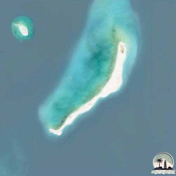
Size: 1.273 km²
Coastline: 10.5 km
Ocean: Indian Ocean
Sea: Laccadive Sea
Continent: Seven seas (open ocean)
Noonu is a Small Island spanning 1.3 km² with a coastline of 10.5 km.
Archipel: Maldive Islands – A tropical paradise in the Indian Ocean, known for their stunning coral reefs, diverse marine life, and luxury resorts.
Tectonic Plate: Sunda – Extends across Southeast Asia, encompassing parts of the Sunda Shelf, known for its interaction with the Australian Plate, contributing to volcanic activity in Indonesia.
The geographic heart of the island is pinpointed at these coordinates:
Latitude: 5.82535892 / Longitude: 73.47452678
Climate and weather of Noonu
Climate Zone: Tropical
Climate Details: Tropical Monsoon Climate
Temperature: Hot
Climate Characteristics: Characterized by heavy rainfall, high humidity, and uniformly high temperatures, but with a distinct short dry season. It features a seasonal reversal of prevailing wind directions.
Topography and nature of Noonu
Timezone: UTC+05:00
Timezone places: Asia/Karachi
Max. Elevation: 4 m
Mean Elevation: -1 m
Vegetation: Open Woodland
Tree Coverage: 20%
The mean elevation is -1 m. The highest elevation on the island reaches approximately 4 meters above sea level. The island is characterized by Plains: Flat, low-lying lands characterized by a maximum elevation of up to 200 meters. On islands, plains are typically coastal lowlands or central flat areas.
Dominating Vegetation: Open Woodland
Characterized by sparsely distributed trees with open canopy allowing sunlight to penetrate, supporting grasses and shrubs underneath. Often found in drier or transitional environments. Noonu has a tree cover of 20 %.
Vegetation: 2 vegetation zones – Low Diversity Island
Islands with two distinct vegetation zones offer slightly more ecological variety. These zones could be due to differences in elevation, moisture, or other environmental factors. While still limited in biodiversity, these islands may offer a contrast between the two zones, such as a coastline with mangroves and an inland area with grassland.
Infrastructure and Travelling to Noonu
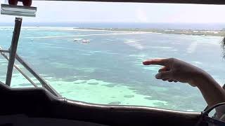
Does the island have a public airport? yes.
Noonu has a public and scheduled airport. The following airports are located on this island: Maafaru International Airport.
Does the island have a major port? no.
There are no major ports on Noonu. The closest major port is MALE, approximately 182 km away.
The mean population of Noonu is 362 per km². Noonu is Moderately Inhabited. The island belongs to Maldives.
Continuing your journey, Vypīn Island is the next notable island, situated merely km away.
Noonu Atoll, Maldives 🇲🇻
short The Noonu atoll is well known for its underwater feast of wide range of coral reefs and lagoons that would facilitate endless ...Noonu Atoll, Maldives 🇲🇻
short The Noonu atoll is well known for its underwater feast of wide ...
short The Noonu atoll is well known for its underwater feast of wide range of coral reefs and lagoons that would facilitate endless ...
"Change In A YEAR": Robinson Noonu MALDIVES
If you're looking for a postcard-perfect paradise to call home, look ...
If you're looking for a postcard-perfect paradise to call home, look no further than Robinson Noonu MALDIVES. Nestled between ...
Maldives - Beach Villa Walkout with Private Pool at Robinson Noonu Resort (Room Tour)
ROBINSON Noonu Malediven 🌴 Cluburlaub im Paradies | All Inclusive mit Cluburlaub.de
Erleben Sie mit dem ROBINSON Noonu einen traumhaften Cluburlaub auf ...
Erleben Sie mit dem ROBINSON Noonu einen traumhaften Cluburlaub auf den Malediven – eine Insel voller Sonne, ...
ROBINSON NOONU
Die familienfreundliche Fernweh-Insel auf den Malediven läd zum ...
Die familienfreundliche Fernweh-Insel auf den Malediven läd zum entspannten Traumurlaub ein: Tauchen, traumhafter ...
Robinson Noonu Maldives Resort | Full 4K Review 2025 | All-Inclusive Paradise
Watch the Full 4K Film of Robinson Noonu Maldives on Vimeo: ...
Maldives - Room Tour of our Overwater Bungalow with Private Infinity Pool at Robinson Noonu Resort
Overwater Villa|Robinson Noonu|Pickyourtrail|Jinali&Malav #shorts #maldives #travel #vacation #life
The bioluminescent beach on Velidhoo Island of Maldives is a tropical paradise in Noonu Atoll
Maldives - Beach Villa Walkout with Private Pool Room at Robinson Noonu Resort (Room Tour)
Noonu Atoll,Soneva Jani,Maldives 🏖️🏝️
Escape to paradise at ROBINSON Noonu, where every moment feels like a dream come true. 🌴✨
ROBINSONNoonu #MaldivesVirtualTour #Maldives #VisitMaldives #Explore ...
ROBINSONNoonu #MaldivesVirtualTour #Maldives #VisitMaldives #Explore #TravelBlog #Traveller #TravelBug #LuxuryTravel ...
Maldives - Robinson Noonu Resort Tour
Robinson Noonu
Find your own slice of paradise at ROBINSON Noonu Maldives! ☀️ ...
Find your own slice of paradise at ROBINSON Noonu Maldives! ☀️ #RobinsonNoonu #MaldivesVirtualTour #Maldives ...
Living the Maldives Dream 🩵 Overwater Bungalow at Robinson Club Noonu
Robinson Club Noonu - Maldives
Maldives | Noonu Atoll | Medhufaru Island, Manadhoo | landing in Soneva Jani.
Maldives #Maldivesresorts #SonevaJani.
Maldives #Maldivesresorts #SonevaJani.
ROBINSON Club Noonu/Around the Island along the beach
Summer 2020 In lockdown time was the best moment to take a video ...
Summer 2020 In lockdown time was the best moment to take a video around our Island.Only Sand blue lagoon and my camera ...
Fodhdhoo island, Noonu Atoll, Maldives
A local island called Fodhdhoo is an example of tranquility and ...
A local island called Fodhdhoo is an example of tranquility and romantic vacations in Maldives. You will be alone on the beach, ...
Velaa Private Island is a luxurious resort located in the Noonu Atoll of the Maldives
It's known for its secluded atmosphere, world-class facilities, and ...
It's known for its secluded atmosphere, world-class facilities, and Michelin-starred dining. #velaa #VelaaPrivateIsland ...
Robinson Noonu Maldives #shorts #luxuryhotel #hotelreview #exclusivehotels
Robinson Noonu Maldives You will encounter the Maldives in a brand-new ...
Robinson Noonu Maldives You will encounter the Maldives in a brand-new way with ROBINSON, whether you're barefoot on the ...
Sun Siyam Resort | Boutique | Island | Male | Maldives | Noonu Atoll | Iri Fushi | beach 🏖️ 🏝️
sunsiyam | #Boutique | #Island | #Male | #Maldives | #noonuatoll | ...
sunsiyam | #Boutique | #Island | #Male | #Maldives | #noonuatoll | Irufushi | #beach #travel #travelgram #traveller #travelling ...
Velaa Private Island, Noonu Atoll, Maldives - Unravel Travel TV
Velaa Private Island in the Maldives is the realization of a dream to ...
Velaa Private Island in the Maldives is the realization of a dream to create a 'beyond luxury' exclusive boutique hideaway.
Robinson Noonu in Maldives
Let Me Be The "Mad Man": Robinson Noonu MALDIVES
Location: Robinsion Noonu, Maldives By Want to Be in Maldives Robinson ...
Location: Robinsion Noonu, Maldives By Want to Be in Maldives Robinson Noonu, also known as the "Mad Man" is a hiking trail ...
Maldives is classified as Developing region: Regions characterized by lower income levels, with economies in the process of industrialization and modernization. The level of income is Upper middle income.
News – Latest Updates and Headlines from Noonu
Stay informed with the most recent news and important headlines from Noonu. Here’s a roundup of the latest developments.
Loading...
Please note: The data used here has been primarily extracted from satellite readings. Deviations from exact values may occur, particularly regarding the height of elevations and population density. Land area and coastline measurements refer to average values at mean high tide.