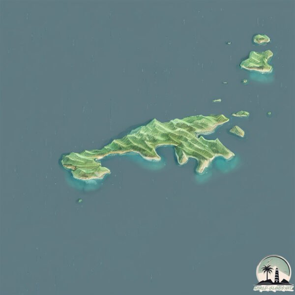
Welcome to Nordland, a Temperate island in the Norwegian Sea, part of the majestic Arctic Ocean. This guide offers a comprehensive overview of what makes Nordland unique – from its geography and climate to its population, infrastructure, and beyond. Dive into the details:
Geography and size of Nordland
Size: 14.6 km²
Coastline: 58 km
Ocean: Arctic Ocean
Sea: Norwegian Sea
Continent: Europe
Nordland is a Medium Island spanning 15 km² with a coastline of 58 km.
Archipel: –
Tectonic Plate: Eurasia – One of the world’s largest tectonic plates, the Eurasian Plate covers a significant portion of Europe and Asia. It’s characterized by diverse geological features, including the Ural Mountains, the European Plain, and the Himalayas formed from its collision with the Indian Plate.
The geographic heart of the island is pinpointed at these coordinates:
Latitude: 67.66347303 / Longitude: 12.65604024
Climate and weather of Nordland
Climate Zone: Temperate
Climate Details: Subpolar Oceanic Climate
Temperature: Cold Summer
Climate Characteristics: Predominantly cold with cool summers and no dry season. Often found in coastal areas at higher latitudes or on islands.
Topography and nature of Nordland
Timezone: UTC+01:00
Timezone places: Europe/Paris
Max. Elevation: m
Mean Elevation: m
Vegetation: Open Woodland
Tree Coverage: 48%
The mean elevation is m. The island is characterized by Mountains: High, steeply elevated landforms. Characterized by both a high maximum elevation (over 500 meters) and a high mean elevation, creating rugged, mountainous terrains on islands.
Dominating Vegetation: Open Woodland
Characterized by sparsely distributed trees with open canopy allowing sunlight to penetrate, supporting grasses and shrubs underneath. Often found in drier or transitional environments. Nordland has a tree cover of 48 %.
Vegetation: 7 vegetation zones – Very Highly Diverse Island
Islands in this range are ecological powerhouses, showcasing a wide array of vegetation zones. Each zone, from lush rainforests to arid scrublands, coastal mangroves to mountainous regions, contributes to a complex and interdependent ecosystem. These islands are often hotspots of biodiversity, supporting numerous species and intricate ecological processes.
Infrastructure and Travelling to Nordland
Does the island have a public airport? yes.
Nordland has a public and scheduled airport. The following airports are located on this island: Værøy Heliport.
Does the island have a major port? no.
There are no major ports on Nordland. The closest major port is REINE, approximately 49 km away.
The mean population of Nordland is 35 per km². Nordland is Gently Populated. The island belongs to Norway.
Continuing your journey, Moskenesoya is the next notable island, situated merely km away.
This Hidden Norwegian Island Will Leave You Speechless 🌊🇳🇴
Discover the stunning beauty of Andøya — a hidden gem in Northern Norway. From dramatic coastal cliffs to peaceful fishing ...This Hidden Norwegian Island Will Leave You Speechless 🌊🇳🇴
Discover the stunning beauty of Andøya — a hidden gem in Northern ...
Discover the stunning beauty of Andøya — a hidden gem in Northern Norway. From dramatic coastal cliffs to peaceful fishing ...
Top 10 Places To Visit in Lofoten & Northern Norway
I recently returned from exploring Lofoten & Northern Norway and I ...
I recently returned from exploring Lofoten & Northern Norway and I can't wait to share this video with you. Enjoy this travel guide ...
Røst is a small island municipality in Nordland county, Norway, Europe
The island has a rich cultural life. Fishing is the main economic ...
The island has a rich cultural life. Fishing is the main economic activity on Røst. There are six fish farms in Røst. During the main ...
Nordland General Store, the heartbeat of Marrowstone Island | Eric's Heroes
You can take a ferry to get there, Edmonds to Kingston. Then you ...
You can take a ferry to get there, Edmonds to Kingston. Then you drive. Eventually, you cross a bridge onto Indian Island.
The Lofoten Islands, located in Nordland County, Norway, are an archipelago in northern Norway
The Lofoten Islands, located in Nordland County, Norway, are an ...
The Lofoten Islands, located in Nordland County, Norway, are an archipelago in northern Norway #beautifulplace #short ...
@Kjerringøy/island Nordland🇳🇴🇳🇴
Best Ways to Get to The Lofoten Islands, Norway
You definitely want to watch this video before going to the Lofoten ...
You definitely want to watch this video before going to the Lofoten islands so you don't make any of the biggest (expensive) ...
ISLAND TOUR IN NORDLAND, NORWAY | Miss Lory Vlog (07)
Hi Fellas, Don't forget to subscribe and hit the notification bell for ...
Hi Fellas, Don't forget to subscribe and hit the notification bell for more uploaded in this channel. I highly appreciate your thumbs ...
Happy Life #25 Island | Nordland, Norway (MRM)
You're free to use this song in any of your videos, but you must ...
You're free to use this song in any of your videos, but you must include the following in your video description (Copy & Paste) ...
Beautiful view of Nordland, Norway #shorts
Beautiful view of Nordland, Norway #shorts Relaxing Content ...
Beautiful view of Nordland, Norway #shorts Relaxing Content Relaxation, Meditation, Study & Sleep Background Music ...
S C E N I C | R O A D #lofotenislands #nordland #norwegiangetaway #norwayroadtrip #visitnorway
Road to Lofoten.
Road to Lofoten.
📍 Red wooden cabin on a small island in a lake, Vestvagoy, Nordland, Lofoten, Norway
Would you live in this remote little red cabin on a beautiful lake in ...
Would you live in this remote little red cabin on a beautiful lake in Norway? Start traveling with booking, follow the link right ...
Höhepunkte der Nordland-Route mit der Mein Schiff Flotte | Mein Schiff
Sehnsuchtsziel Norwegen: An Bord der Mein Schiff Flotte erlebt ihr die ...
Sehnsuchtsziel Norwegen: An Bord der Mein Schiff Flotte erlebt ihr die schönsten Fjorde und großartige Natur. An nahezu endlos ...
8s | View 4m Reinebringen Mountain (448m) | Breathtaking view | Moskenes | Lofoten Islands | Norway
reinebringen #mountains #448 #breathtakingvideo #moskenes ...
reinebringen #mountains #448 #breathtakingvideo #moskenes #lofotenislands #lofoten #norway #norwaylife #norwayshorts ...
Mit dem Campinganhänger in 5 Monaten um Island. Reise-Doku Teil 3: „Ostland und Östliches Nordland“
Ich reise fünf Monate lang mit dem Campinganhänger rund um Island. ...
Ich reise fünf Monate lang mit dem Campinganhänger rund um Island. Auch im Teil 3 meiner Filmreihe bin ich im „Ostland“, also ...
Mit dem Campinganhänger in 5 Monaten um Island. Reise-Dokumentation Teil 4: „Östliches Nordland“
BESCHREIBUNG Ich reise fünf Monate lang mit dem Campinganhänger rund ...
BESCHREIBUNG Ich reise fünf Monate lang mit dem Campinganhänger rund um Island. In Teil 4 meiner Filmreihe bin ich im ...
Mit dem Campinganhänger in 5 Monaten um Island. Reise-Doku Teil 5: "Hochland, Nordland, Westfjorde"
Ich reise seit 4 Monaten mit dem Campinganhänger rund um Island (Mai ...
Ich reise seit 4 Monaten mit dem Campinganhänger rund um Island (Mai 2025 bis aktuell September 2025). Im fünften Teil meiner ...
Lofoten from above: -The amazing Lofoten Islands in north Norway
About the Lofoten islands ( Lofoten is a group of islands in the ...
About the Lofoten islands ( Lofoten is a group of islands in the northern part of Norway.) Lofoten (Island Group) is an archipelago ...
Welcome to Lofoten Islands, Nordland, Norway #amazingcity#beautifulcity#shortvideo#nordlanview#viral
Beautiful view in Lofoten Islands, Nordland, Norway.
Beautiful view in Lofoten Islands, Nordland, Norway.
Træna, Norway: Explore Ancient Caves & Arctic Coastal Magic! ❄️⛰️
Did you know there's a remote Norwegian archipelago where jagged peaks ...
Did you know there's a remote Norwegian archipelago where jagged peaks rise from Arctic waters, and music festivals echo in ...
Explore Lofoten, Nordland-Vesterålen region, Mefjordvær Senja Island, Norway
A summer journey 2017 to Northern part of Norway with soundtrack from ...
A summer journey 2017 to Northern part of Norway with soundtrack from Secret Garden-Gates if Dawn, Sommerfuggel i ...
10-step-shorts #7 #norway #helgeland #nordland #ferry #boat #island #coastline #travel #lurøy
LØKTA island#eastersunday2022#islandlife🇳🇴#beautifulcreationofGod🌊🌞
Løkta is an island in the municipality of Dønna in Nordland county, ...
Løkta is an island in the municipality of Dønna in Nordland county, Norway. The 17.4-square-kilometre island is located between ...
HOW TO TRAVEL NORWAY IN 9 DAYS!! (GEIRANGER, LOEN, BERGEN, TROLLSTIGEN, LOFOTEN)
In this video, we are sharing with you some travel ideas from our road ...
In this video, we are sharing with you some travel ideas from our road trip around Norway, which we took last summer in 2022.
Lofoten is an archipelago and a traditional district in the county of Nordland, Norway.
UIPNORWAY @VisitEuropeOfficial @VisitNorway @Visitlofoten.
UIPNORWAY @VisitEuropeOfficial @VisitNorway @Visitlofoten.
Norway is classified as Developed region: nonG7: Developed economies outside of the Group of Seven, characterized by high income and advanced economic structures. The level of income is High income: OECD.
News – Latest Updates and Headlines from Nordland
Stay informed with the most recent news and important headlines from Nordland. Here’s a roundup of the latest developments.
Loading...
Please note: The data used here has been primarily extracted from satellite readings. Deviations from exact values may occur, particularly regarding the height of elevations and population density. Land area and coastline measurements refer to average values at mean high tide.