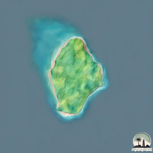
Nosy Kalakajoro
Welcome to Nosy Kalakajoro, a Tropical island in the Mozambique Channel, part of the majestic Indian Ocean. This guide offers a comprehensive overview of what makes Nosy Kalakajoro unique – from its geography and climate to its population, infrastructure, and beyond. Dive into the details:
- Geography and Size: Explore the island’s size and location.
- Climate and Weather: Weather patterns and temperature.
- Topography and Nature: Uncover the natural wonders of the island.
- Infrastructure and Travelling: Insights on reaching, staying, and making the most of your visit.
- News and Headlines: Latest News.
Geography and size of Nosy Kalakajoro
Size: 3.74 km²
Coastline: 8.1 km
Ocean: Indian Ocean
Sea: Mozambique Channel
Continent: Africa
Nosy Kalakajoro is a Small Island spanning 3.7 km² with a coastline of 8.1 km.
Archipel: –
Tectonic Plate: Somalia – A large tectonic plate covering the Horn of Africa and parts of the Indian Ocean, known for the East African Rift where it’s splitting away from the African Plate.
The geographic heart of the island is pinpointed at these coordinates:
Latitude: -13.94518392 / Longitude: 47.76854111
Climate and weather of Nosy Kalakajoro
Climate Zone: Tropical
Climate Details: Tropical Savanna, Wet
Temperature: Hot
Climate Characteristics: Defined by distinct wet and dry seasons with high temperatures year-round. Pronounced rainfall occurs during the wet season, while the dry season is marked by drought.
Topography and nature of Nosy Kalakajoro
Timezone: UTC+03:00
Timezone places: Asia/Riyadh
Max. Elevation: 89 m
Mean Elevation: 51 m
Vegetation: Evergreen Broadleaf Forest
Tree Coverage: 84%
The mean elevation is 51 m. The highest elevation on the island reaches approximately 89 meters above sea level. The island is characterized by Plains: Flat, low-lying lands characterized by a maximum elevation of up to 200 meters. On islands, plains are typically coastal lowlands or central flat areas.
Dominating Vegetation: Evergreen Broadleaf Forest
Characterized by dense, lush canopies of broadleaf trees that retain their leaves year-round. These forests are typically found in tropical and subtropical regions and are known for their high biodiversity. Nosy Kalakajoro has a tree cover of 84 %.
Vegetation: 3 vegetation zones – Moderately Diverse Island
These islands start to show a broader range of ecological niches. With three vegetation zones, they may offer a mix of ecosystems like coastal areas, inland woods, and perhaps a distinct wetland or dry area. This diversity supports a wider range of flora and fauna, making these islands more ecologically complex than those with minimal diversity.
Infrastructure and Travelling to Nosy Kalakajoro
Does the island have a public airport? no.
There is no public and scheduled airport on Nosy Kalakajoro. The nearest airport is Analalava Airport, located 75 km away.
Does the island have a major port? no.
There are no major ports on Nosy Kalakajoro. The closest major port is ANDOANY, approximately 83 km away.
The mean population of Nosy Kalakajoro is 21 per km². Nosy Kalakajoro is Gently Populated. The island belongs to Madagascar.
Continuing your journey, Nosy Berafia is the next notable island, situated merely km away.
🌅 Video aérienne de [Nosy kalakajoro - Radama] à Madagascar | Hdoi360 | Video drone Nosy Be
![🌅 Video aérienne de [Nosy kalakajoro - Radama] à Madagascar | Hdoi360 | Video drone Nosy Be](https://i.ytimg.com/vi/yGAXhXY-P94/mqdefault.jpg)


![🌅 Vidéo [PRO] du Makilodge à Nosy Komba Madagascar | Hdoi360 - Photographe Nosy Be](https://i.ytimg.com/vi/hPOGG-BPUrA/mqdefault.jpg)


Madagascar is classified as Least developed region: Countries that exhibit the lowest indicators of socioeconomic development, with the lowest Human Development Index ratings. The level of income is Low income.
News – Latest Updates and Headlines from Nosy Kalakajoro
Stay informed with the most recent news and important headlines from Nosy Kalakajoro. Here’s a roundup of the latest developments.
Please note: The data used here has been primarily extracted from satellite readings. Deviations from exact values may occur, particularly regarding the height of elevations and population density. Land area and coastline measurements refer to average values at mean high tide.