Nui Kak Ba
Welcome to Nui Kak Ba, a Temperate island in the South China Sea, part of the majestic Pacific Ocean. This guide offers a comprehensive overview of what makes Nui Kak Ba unique – from its geography and climate to its population, infrastructure, and beyond. Dive into the details:
- Geography and Size: Explore the island’s size and location.
- Climate and Weather: Weather patterns and temperature.
- Topography and Nature: Uncover the natural wonders of the island.
- Infrastructure and Travelling: Insights on reaching, staying, and making the most of your visit.
- News and Headlines: Latest News.
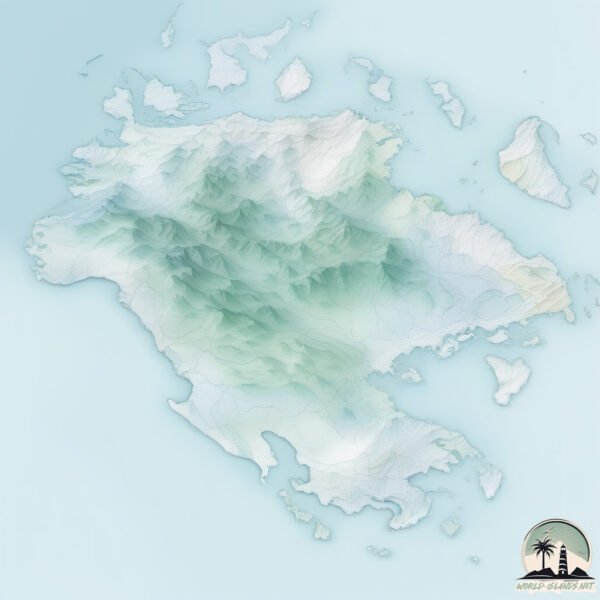
Geography and size of Nui Kak Ba
Size: 155.7 km²
Coastline: 252.7 km
Ocean: Pacific Ocean
Sea: South China Sea
Continent: Asia
Nui Kak Ba is a Large Island spanning 156 km² with a coastline of 253 km.
Archipel: –
Tectonic Plate: Eurasia – One of the world’s largest tectonic plates, the Eurasian Plate covers a significant portion of Europe and Asia. It’s characterized by diverse geological features, including the Ural Mountains, the European Plain, and the Himalayas formed from its collision with the Indian Plate.
The geographic heart of the island is pinpointed at these coordinates:
Latitude: 20.7991132 / Longitude: 107.01093888
Climate and weather of Nui Kak Ba
Climate Zone: Temperate
Climate Details: Monsoon-Influenced Humid Subtropical Climate
Temperature: Hot Summer
Climate Characteristics: Known for hot, humid summers with significant monsoon rains, contrasted by mild, drier winters.
Topography and nature of Nui Kak Ba
Timezone: UTC+07:00
Timezone places: Asia/Jakarta
Max. Elevation: 213 m
Mean Elevation: 81 m
Vegetation: Evergreen Broadleaf Forest
Tree Coverage: 64%
The mean elevation is 81 m. The highest elevation on the island reaches approximately 213 meters above sea level. The island is characterized by Hills: Gently sloping landforms with rounded tops, having a maximum elevation between 200 and 500 meters. Hills contribute to a varied landscape on islands.
Dominating Vegetation: Evergreen Broadleaf Forest
Characterized by dense, lush canopies of broadleaf trees that retain their leaves year-round. These forests are typically found in tropical and subtropical regions and are known for their high biodiversity. Nui Kak Ba has a tree cover of 64 %.
Vegetation: 14 vegetation zones – Exceptionally Diverse Island
Islands with more than ten vegetation zones are among the most ecologically rich and varied in the world. These islands are akin to miniature continents, boasting an incredible array of ecosystems. The sheer range of habitats, from high peaks to deep valleys, rainforests to deserts, creates a mosaic of life that is unparalleled. They are crucial for conservation and ecological studies.
Infrastructure and Travelling to Nui Kak Ba
Does the island have a public airport? no.
There is no public and scheduled airport on Nui Kak Ba. The nearest airport is Cat Bi International Airport, located 21 km away.
Does the island have a major port? no.
There are no major ports on Nui Kak Ba. The closest major port is HON GAI, approximately 10 km away.
The mean population of Nui Kak Ba is 159 per km². Nui Kak Ba is Moderately Inhabited. The island belongs to Vietnam.
Continuing your journey, Xa Phong Coc is the next notable island, situated merely km away.
CÁT BÀ ISLAND, VIETNAM | 8 Awesome Things To Do On Cát Bà Island


Vietnam is classified as Emerging region: G20: Group of Twenty – Major economies comprising both developed and emerging countries, representing the world’s largest economies. The level of income is Lower middle income.
News – Latest Updates and Headlines from Nui Kak Ba
Stay informed with the most recent news and important headlines from Nui Kak Ba. Here’s a roundup of the latest developments.
Please note: The data used here has been primarily extracted from satellite readings. Deviations from exact values may occur, particularly regarding the height of elevations and population density. Land area and coastline measurements refer to average values at mean high tide.