Welcome to Nurana, a Dry island in the Persian Gulf, part of the majestic Indian Ocean. This guide offers a comprehensive overview of what makes Nurana unique – from its geography and climate to its population, infrastructure, and beyond. Dive into the details:
Geography and size of Nurana
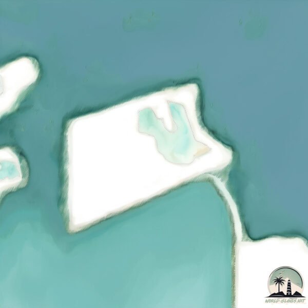
Size: 1.413 km²
Coastline: 5 km
Ocean: Indian Ocean
Sea: Persian Gulf
Continent: Asia
Nurana is a Small Island spanning 1.4 km² with a coastline of 5 km.
Archipel: –
Tectonic Plate: Arabia – A major tectonic plate covering the Arabian Peninsula and parts of the Middle East. The plate is primarily continental and known for its collision with the Eurasian Plate, leading to the uplift of the Zagros Mountains.
The geographic heart of the island is pinpointed at these coordinates:
Latitude: 26.25661336 / Longitude: 50.49359679
Climate and weather of Nurana
Climate Zone: Dry
Climate Details: Hot Deserts Climate
Temperature: Hot
Climate Characteristics: Dominated by extremely hot temperatures, this climate is marked by minimal rainfall and barren landscapes. Nights often experience drastic temperature drops.
Topography and nature of Nurana
Timezone: UTC+03:00
Timezone places: Asia/Riyadh
Max. Elevation: -1 m
Mean Elevation: -1 m
Vegetation: Sparse Vegetation
Tree Coverage: 8%
The mean elevation is -1 m. Remarkably, this unique island barely emerges above the sea level, showcasing nature’s fascinating interplay with the ocean. The island is characterized by Plains: Flat, low-lying lands characterized by a maximum elevation of up to 200 meters. On islands, plains are typically coastal lowlands or central flat areas.
Dominating Vegetation: Sparse Vegetation
These regions have limited plant growth, typically due to extreme conditions like aridity or poor soils. Vegetation is scattered and consists of hardy plant species. Nurana has a tree cover of 8 %.
Vegetation: 1 vegetation zones – Minimal Diversity Island
These islands exhibit the most basic level of ecological diversity, often characterized by a single dominant vegetation type. This could be due to extreme environmental conditions, limited land area, or significant human impact. They represent unique ecosystems where specific species have adapted to thrive in these singular environments.
Infrastructure and Travelling to Nurana
Does the island have a public airport? no.
There is no public and scheduled airport on Nurana. The nearest airport is Bahrain International Airport, located 15 km away.
Does the island have a major port? no.
There are no major ports on Nurana. The closest major port is AL MANAMAH, approximately 9 km away.
The mean population of Nurana is per km². Nurana is . The island belongs to Bahrain.
Continuing your journey, Umm an Na‘sān is the next notable island, situated merely km away.
Nurana Islands | Bahrain| Bahrain Islands| Bahrain Vlog | @TravelwithG123
Nurana Islands | Bahrain| Bahrain Islands| @TravelwithG123 Nurana Islands are a group of 2 islands to the east of Northern City ...Nurana Islands | Bahrain| Bahrain Islands| Bahrain Vlog | @TravelwithG123
Nurana Islands | Bahrain| Bahrain Islands| @TravelwithG123 Nurana ...
Nurana Islands | Bahrain| Bahrain Islands| @TravelwithG123 Nurana Islands are a group of 2 islands to the east of Northern City ...
NURANA ISLANDS IN BAHRAIN IS AMAZING!!
Nurana Islands are a group of 2 artificial islands to the east of ...
Nurana Islands are a group of 2 artificial islands to the east of Northern City in the archipelago of Bahrain, which lie 9 km (5.6 mi) ...
Beautiful Nurana Island
Nurana Islands are a group of 2 artificial islands to the east of ...
Nurana Islands are a group of 2 artificial islands to the east of Northern City in the archipelago of Bahrain, which lie 9 km (5.6 mi) ...
Nurana Island, Bahrain
The place, people love to reach here for fishing,bike riding,horse ...
The place, people love to reach here for fishing,bike riding,horse riding,to take photo shoots etc.The island is 9Km away from ...
Nurana Island in Bahrain | Family Vlog | Best beach destination for family outing in Bahrain
Looking for the perfect beach destination in Bahrain? Visit the Nurana ...
Looking for the perfect beach destination in Bahrain? Visit the Nurana Islands located between the Jidhafs and the Northern City.
Nurana island # islands in bahrain #bahrainlife #beach #bahrain #explore must
Nurana island in bahrain - travel vlog
NURANA ISLAND RIDE IN BAHRAIN
Friday morning ride on our way to Nurana Island in Bahrain Via Bahrain ...
Friday morning ride on our way to Nurana Island in Bahrain Via Bahrain Fort. A 19km ride. A warmup ride to startup the new year!
Nurana Island, Bahrain| Bali the Doggo in Nurana Island
Nurana Island, Bahrain tour 4k
Travelling and exploring Nurana Island, Bahrain Kingdom of Bahrain. ...
Travelling and exploring Nurana Island, Bahrain Kingdom of Bahrain. Best tourist spot in Bahrain. Top 10 things to visit in Bahrain.
Nurana Island Bahrain
Nurana Island budaiya Bahrain.
Nurana Island budaiya Bahrain.
Places to visit in Bahrain || Nurana island bahrain | Nurana fishing point /Nurana islands and beach
Places to visit in Bahrain nurana island bahrain Tourists places to ...
Places to visit in Bahrain nurana island bahrain Tourists places to visit in Bahrain Bahrain attraction Bahrain beaches #bahrain ...
Nurana Islands | Nurana Island Bahrain
Nurana Islands | Nurana Island Bahrain #bahrain #bahrainbeach #nurana ...
Nurana Islands | Nurana Island Bahrain #bahrain #bahrainbeach #nurana #awalichurch.
Nurana Island Bahrain 🇧🇭 | Aarja Jagath Kids Vlog | Family & Kids Travel
Explore the beauty of Nurana Island, Bahrain with Aarja Jagath in this ...
Explore the beauty of Nurana Island, Bahrain with Aarja Jagath in this fun and joyful kids vlog 🏝️ This family travel vlog in ...
#BAHRAIN NEW BEACH EXPLORED/#Fishing @ Nurana island 🏝️
when beauty of bahrain explored, we went to man made Nurana island and ...
when beauty of bahrain explored, we went to man made Nurana island and captured some scenic b.eauty of bahrain.
Nurana island | Open Beach | தமிழ் #india2bahrain #bahrain #island #beach #Bahrain tourist place.
Nurana Islands are a group of 2 artificial islands to the east of ...
Nurana Islands are a group of 2 artificial islands to the east of Northern City in the archipelago of Bahrain, which lie 9 km (5.6 mi) ...
Nurana Island in Bahrain
Cooking and Entertainment - Recommended for you.
Cooking and Entertainment - Recommended for you.
Nurana Beach ||Nurana Island Bahrain
myfirstshortvideo #Nurana Island #Nurana Beach.
myfirstshortvideo #Nurana Island #Nurana Beach.
BAHRAIN NURANA ISLAND/FISH ON MASTER MARK!!(@Amor Villadelrey Channel)
BAHRAIN NURANA ISLAND/FISH ON MASTER MARK!!(@Amor Villadelrey Channel)
BAHRAIN NURANA ISLAND/FISH ON MASTER MARK!!(@Amor Villadelrey Channel)
Nurana Island - Bahrain l Travel in Bahrain
Nurana Island – Bahrain There are groups of 2 islands to the east of ...
Nurana Island – Bahrain There are groups of 2 islands to the east of Northern City in the archipelago of Bahrain, which lies 9 km ...
Nurana Island In The Evening💦🌊 | A Beautiful Evening After Sunset|Bahrain
Nurana Island❤️|Sunset Beauty|Beach Life❤️|Bahrain #worldofanayra ...
Nurana Island❤️|Sunset Beauty|Beach Life❤️|Bahrain #worldofanayra #bahrain #island #beachlife #sunsetvibes #beaches ...
Nurana Island / Bahrain travel vlog/weekend vlog
Published on 11th January, 2021 Bahrain # travel vlog # Nurana Island ...
Published on 11th January, 2021 Bahrain # travel vlog # Nurana Island # beach vlog# weekend outing# Follow me on Facebook ...
beautiful hidden spot Nurana island @bahrain #bahrainlife #bestview #bahrainnightlife #bahrain
Nurana Island: A slice of heaven on Earth #sunset #bahrain #pravasi_malayaly #homeawayfromhome
Bahrain is classified as Developing region: Regions characterized by lower income levels, with economies in the process of industrialization and modernization. The level of income is High income: nonOECD.
News – Latest Updates and Headlines from Nurana
Stay informed with the most recent news and important headlines from Nurana. Here’s a roundup of the latest developments.
Loading...
Please note: The data used here has been primarily extracted from satellite readings. Deviations from exact values may occur, particularly regarding the height of elevations and population density. Land area and coastline measurements refer to average values at mean high tide.