Welcome to Nyord, a Temperate island in the Baltic Sea, part of the majestic Atlantic Ocean. This guide offers a comprehensive overview of what makes Nyord unique – from its geography and climate to its population, infrastructure, and beyond. Dive into the details:
Geography and size of Nyord
Size: 5.677 km²
Coastline: 12.2 km
Ocean: Atlantic Ocean
Sea: Baltic Sea
Continent: Europe
Nyord is a Small Island spanning 5.7 km² with a coastline of 12.2 km.
Archipel: –
Tectonic Plate: Eurasia – One of the world’s largest tectonic plates, the Eurasian Plate covers a significant portion of Europe and Asia. It’s characterized by diverse geological features, including the Ural Mountains, the European Plain, and the Himalayas formed from its collision with the Indian Plate.
The geographic heart of the island is pinpointed at these coordinates:
Latitude: 55.04734318 / Longitude: 12.21177432
Climate and weather of Nyord
Climate Zone: Temperate
Climate Details: Temperate Oceanic Climate
Temperature: Warm Summer
Climate Characteristics: Known for its moderate year-round temperatures with ample rainfall and no dry season. Warm summers are characteristic.
Topography and nature of Nyord
Timezone: UTC+01:00
Timezone places: Europe/Paris
Max. Elevation: 6 m
Mean Elevation: 0 m
Vegetation: Agricultural Mosaic
Tree Coverage: 42%
The mean elevation is 0 m. The highest elevation on the island reaches approximately 6 meters above sea level. The island is characterized by Plains: Flat, low-lying lands characterized by a maximum elevation of up to 200 meters. On islands, plains are typically coastal lowlands or central flat areas.
Dominating Vegetation: Agricultural Mosaic
A mix of cropland and natural vegetation, often seen in rural landscapes where agricultural fields are interspersed with patches of natural habitats. Nyord has a tree cover of 42 %.
Vegetation: 6 vegetation zones – Very Highly Diverse Island
Islands in this range are ecological powerhouses, showcasing a wide array of vegetation zones. Each zone, from lush rainforests to arid scrublands, coastal mangroves to mountainous regions, contributes to a complex and interdependent ecosystem. These islands are often hotspots of biodiversity, supporting numerous species and intricate ecological processes.
Infrastructure and Travelling to Nyord
Does the island have a public airport? no.
There is no public and scheduled airport on Nyord. The nearest airport is Copenhagen Kastrup Airport, located 77 km away.
Does the island have a major port? no.
There are no major ports on Nyord. The closest major port is STEGE, approximately 9 km away.
The mean population of Nyord is 5 per km². Nyord is Gently Populated. The island belongs to Denmark.
Continuing your journey, Mon is the next notable island, situated merely km away.
I explore the village on the island of Nyord
In this video I take a walk through the small villagve, Nyord, on ther island of the same name, north of the island of Møn.I explore the village on the island of Nyord
In this video I take a walk through the small villagve, Nyord, on ther ...
In this video I take a walk through the small villagve, Nyord, on ther island of the same name, north of the island of Møn.
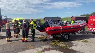
26.08.23 | Shorts | Nyord | Båd kæntret i havn | Boat capsized in port at Nyord Island
English description below... Kamera 2 - kort 4K video Brandvæsen, ...
English description below... Kamera 2 - kort 4K video Brandvæsen, ambulance og politi rykkede ud til mulig drukneulykke, da en ...
Exploring Møn Part 1 - Stege, Nyord, Fanefjord Kirke, and some Øl!!
This is the first episode in a 2 part series where we travel to Møn. ...
This is the first episode in a 2 part series where we travel to Møn. Thanks to your suggestions! We do a quick walking tour around ...
Nyord - Under the Moon 4K
En kort timelapse film om den lille ø Nyord, som er certificeret Dark ...
En kort timelapse film om den lille ø Nyord, som er certificeret Dark Sky. Music: Spring is here/Tell no tales via Musicvine.
The Danish Island of Nyord
Let the Danish island of Nyord amaze you with its stunning beauty.
Let the Danish island of Nyord amaze you with its stunning beauty.
26.08.23 | 4K | Nyord | Båd kæntret i havn | Boat capsized in port at Nyord Island
English description below... Kamera 3 - 4K video Vordingborg ...
English description below... Kamera 3 - 4K video Vordingborg brandvæsen, en ambulance med paramediciner og politi rykkede ...
Ein Besuch auf der Insel Nyord | Dänemark Vlog 6
Hier unsere Dänemark Empfehlungen: ...
Nyord
Nyord is a small island north of Møn with an area of 4.99 km² and 35 ...
Nyord is a small island north of Møn with an area of 4.99 km² and 35 inhabitants. From 1968, the island was land-fixed with Møn ...
Teil 30 WoMo-Tour um die Ostsee: Inseln Møn und Nyord
Dänische Inseln sind schon etwas Besonderes; sie bieten pure ...
Dänische Inseln sind schon etwas Besonderes; sie bieten pure Entspannung und Beschaulichkeit. Z. B. die kleine Schwesterinsel ...
Island Hopping - Panoramic Cycling route between the islands Møn and Nyord, Denmark
Bicycle routes of Møn and South Zealand.
Bicycle routes of Møn and South Zealand.
Nyord By & Havn, Møn 🅿️🆓🛥️
MyMaps for GPS: ...
Møn und Nyord von oben
Die Inselhauptstadt Stege, das grüne Waldgebiet Ulvshale mit seinem ...
Die Inselhauptstadt Stege, das grüne Waldgebiet Ulvshale mit seinem langen Sandstrand und die kleine Naturschönheit Nyord ...
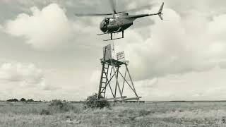
🚁 Historisch: Aufbau des Vogelturms auf Nyord per Hubschrauber (1987)
Komm mit auf eine Zeitreise zurück ins Jahr 1987! Dieses Video zeigt ...
Komm mit auf eine Zeitreise zurück ins Jahr 1987! Dieses Video zeigt spektakuläre und seltene Aufnahmen von der Insel Nyord ...
Waving wheat of Nyord 2013 Edition
Green fields of wheat waving in the wind on a little island called ...
Green fields of wheat waving in the wind on a little island called Nyord in Denmark.
Nyord nord for Møn. En Morten Koch perle Ep6. #danmark #komoot #denmark #udinaturen
Nyord er en lille perle nord for Møn. Morten Koch stil. Gamle gårde, ...
Nyord er en lille perle nord for Møn. Morten Koch stil. Gamle gårde, som familier har eget i generationer. Bestemt et besøg hver.
Blick auf die Insel Nyord von der Insel Mön aus.
Herrliche Natur im Gebiet zwischen den Inseln. Viele Zugvögel machen ...
Herrliche Natur im Gebiet zwischen den Inseln. Viele Zugvögel machen hier halt, bevor es in den Süden geht. Hier nisten aber ...
Møn (Nyord)
One day roadtrip from Copenhagen to Møn, Nyord has the smallest museum ...
One day roadtrip from Copenhagen to Møn, Nyord has the smallest museum in Denmark ,the museum of Nyord's pilots.
Postbåden (Postboot) Røret in Nyord
Blogpost über die Inseln Møn und Nyord und über das Postboot: ...
Blogpost über die Inseln Møn und Nyord und über das Postboot: ...
$200 vs $700 wetsuit😳😨#surfing #surf #wetsuit
Shop Wetsuits: ...
Shop Wetsuits: ...
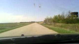
Nyord, Denmark The road to
Vejen gennem Ulfshale Skov, over den ensporede bro, videre over Nyord ...
Vejen gennem Ulfshale Skov, over den ensporede bro, videre over Nyord Enge og til Nyord by. The road til the Island Nyord, ...
Nyord. 19 marts 2022
En dejlig forårs dag i marts måned med høj sol og 12 grader.
En dejlig forårs dag i marts måned med høj sol og 12 grader.
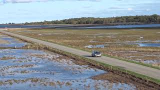
Vejen til halvøen Nyord
Vådområdet mellem Ulvshale og Nyord er et paradis for vadefugle. På ...
Vådområdet mellem Ulvshale og Nyord er et paradis for vadefugle. På Nyord-siden står et fugletårn, hvorfra denne lille film er ...
Nyord
Et lille besøg på Nyord en hyggelig lille Ø med en god kro.
Et lille besøg på Nyord en hyggelig lille Ø med en god kro.
Boat trip - Flex 18 - @Nyord (near Møn), Denmark - 29. May 2021
This Saturday called for a boat trip on my Flex 18 speedboat. With ...
This Saturday called for a boat trip on my Flex 18 speedboat. With long time friend Michael we departed from Præstø with Nyord ...
Camønoen // episode 1: Damsholte - Nyord
Vi gik 25 km på Camønoen fra Damsholte (NyGammelsø B&B) til Nyord ...
Vi gik 25 km på Camønoen fra Damsholte (NyGammelsø B&B) til Nyord fuglereservat (Hyldevang shelterplads). Vandringen var ...
Denmark is classified as Developed region: nonG7: Developed economies outside of the Group of Seven, characterized by high income and advanced economic structures. The level of income is High income: OECD.
News – Latest Updates and Headlines from Nyord
Stay informed with the most recent news and important headlines from Nyord. Here’s a roundup of the latest developments.
Loading...
Please note: The data used here has been primarily extracted from satellite readings. Deviations from exact values may occur, particularly regarding the height of elevations and population density. Land area and coastline measurements refer to average values at mean high tide.