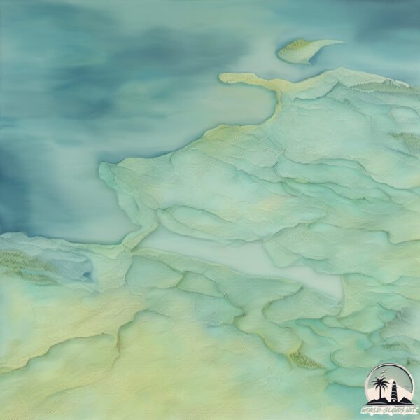
Welcome to Olivier, a Continental island in the Beaufort Sea, part of the majestic Arctic Ocean. This guide offers a comprehensive overview of what makes Olivier unique – from its geography and climate to its population, infrastructure, and beyond. Dive into the details:
Geography and size of Olivier
Size: 2.93 km²
Coastline: 15.5 km
Ocean: Arctic Ocean
Sea: Beaufort Sea
Continent: North America
Olivier is a Small Island spanning 2.9 km² with a coastline of 15.5 km.
Archipel: –
Tectonic Plate: North America – Covers North America and parts of the Atlantic and Arctic Oceans, characterized by diverse geological features and varying levels of seismic activity.
The geographic heart of the island is pinpointed at these coordinates:
Latitude: 68.96794217 / Longitude: -135.82000318
Climate and weather of Olivier
Climate Zone: Continental
Climate Details: Subarctic Climate
Temperature: Cold Summer
Climate Characteristics: Characterized by long, extremely cold winters and short, cool summers, often found in northern latitudes of North America and Eurasia.
Topography and nature of Olivier
Timezone: UTC-07:00
Timezone places: America/Denver
Max. Elevation: -1 m
Mean Elevation: -4 m
Vegetation: Herbaceous Cover
Tree Coverage: 74%
The mean elevation is -4 m. Remarkably, this unique island barely emerges above the sea level, showcasing nature’s fascinating interplay with the ocean. The island is characterized by Plains: Flat, low-lying lands characterized by a maximum elevation of up to 200 meters. On islands, plains are typically coastal lowlands or central flat areas.
Dominating Vegetation: Herbaceous Cover
Comprising mainly of grasses, herbs, and ferns, these areas are common in prairies, meadows, and savannas, and can vary widely in species composition. Olivier has a tree cover of 74 %.
Vegetation: 7 vegetation zones – Very Highly Diverse Island
Islands in this range are ecological powerhouses, showcasing a wide array of vegetation zones. Each zone, from lush rainforests to arid scrublands, coastal mangroves to mountainous regions, contributes to a complex and interdependent ecosystem. These islands are often hotspots of biodiversity, supporting numerous species and intricate ecological processes.
Infrastructure and Travelling to Olivier
Does the island have a public airport? no.
There is no public and scheduled airport on Olivier. The nearest airport is Aklavik/Freddie Carmichael Airport, located 95 km away.
Does the island have a major port? no.
There are no major ports on Olivier. The closest major port is TUKTOYAKTUK, approximately 277 km away.
The mean population of Olivier is 0 per km². Olivier is Uninhabited. The island belongs to Canada.
Continuing your journey, Ellice is the next notable island, situated merely km away.
GP250: Olivier Jacque vs. Shinya Nakano (Phillip Island 2000)
GP250: Olivier Jacque vs. Shinya Nakano (Phillip Island 2000)
300 Days Alone on an Island - A Robinson Crusoe Adventure in the Pacific Ocean
Welcome to our amazing adventure! In this video, we'll be joining our ...
Welcome to our amazing adventure! In this video, we'll be joining our hero Xavier Rosset on a real-life Robinson Crusoe ...
I Snuck onto Jeffrey Epstein’s Island…
Become a Channel Member to help support the channel! ...
Barry Gibb & Olivia Newton-John - Islands in The Stream - HD
Barry Gibb & Olivia Newton-John - Islands in The Stream - HD 2022 HD REL.
Barry Gibb & Olivia Newton-John - Islands in The Stream - HD 2022 HD REL.
Arrow - Oliver Queen is Rescued
A scene 5 years in the making! Oliver Queen is finally rescued off the ...
A scene 5 years in the making! Oliver Queen is finally rescued off the shores of Lian Yu! Thanks to DC Heroes United ...
Oliver and Diggle meet years later 😢 #shorts
Diggle sees oliver years later.. #theflash #greenarrow #oliver ...
Diggle sees oliver years later.. #theflash #greenarrow #oliver #johndiggle #flash #cw #dc #dccomics.
Oliver threatens Felicity 🥶 #shorts
arrowverse #arrow #cw #dc #theflash #barryallen #flash #fyp #viral #4k ...
arrowverse #arrow #cw #dc #theflash #barryallen #flash #fyp #viral #4k #edit #dccomics #grantgustin #greenarrow #shorts.
Oliver Tree - All That x Alien Boy [Official Music Video]
Oliver Tree - All That x Alien Boy [Official Music Video] New Album ...
Oliver Tree - All That x Alien Boy [Official Music Video] New Album 'Alone In A Crowd' out now: ...
Sara meets Earth-16 Oliver in 2046 #shorts
Sara meets earth-16 oliver in 2046.. #theflash #barryallen #arrow ...
Sara meets earth-16 oliver in 2046.. #theflash #barryallen #arrow #greenarrow #oliver #saralance #loislane #legendsoftomorrow ...
Oliver and Diggle meet their kids from the future #shorts
team arrow learns the kids are from 2040.. #theflash #barryallen ...
team arrow learns the kids are from 2040.. #theflash #barryallen #arrow #greenarrow #johndiggle #teamarrow #cwtheflash ...
Roy tells Oliver how he died #shorts
arrowverse #arrow #cw #dc #theflash #barryallen #flash #fyp #viral #4k ...
arrowverse #arrow #cw #dc #theflash #barryallen #flash #fyp #viral #4k #edit #dccomics #grantgustin #greenarrow #shorts.
Oliver sees them again after a long time #shorts
oliver and his son 🙁 #theflash #barryallen #arrow #greenarrow ...
oliver and his son 🙁 #theflash #barryallen #arrow #greenarrow #cwtheflash #dccomics #grantgustin #stephenamell #flash ...
Arrow cast 2012-2024 #arrowverse #shorts #thenandnowchallenge
the cast of Arrow season 1 2012-2024.
the cast of Arrow season 1 2012-2024.
Oliver reveals his identity to the world #shorts
Oliver reveals he's green arrow to the world.. #greenarrow #oliver ...
Oliver reveals he's green arrow to the world.. #greenarrow #oliver #arrow #saralance #laurellance #teamarrow #cwarrow #cw #dc ...
Oliver gets attacked at home #oliverqueen #arrow #greenarrow
arrow 1x05 #cw #arrowverse #arrow #greenarrow #oliverqueen #diggle.
arrow 1x05 #cw #arrowverse #arrow #greenarrow #oliverqueen #diggle.
Oliver Tree & Robin Schulz - Miss You [Official Music Video]
Oliver Tree & Robin Schulz - Miss You [Music Video] New Album 'Alone ...
Oliver Tree & Robin Schulz - Miss You [Music Video] New Album 'Alone In A Crowd' out now: ...
I Snuck onto Jeffrey Epstein's Island...
Oliver finds out that Sara is alive #oliverqueen #greenarrow #arrow
arrowverse #arrow #oliverqueen #saralance #greenarrow #blackcanary.
arrowverse #arrow #oliverqueen #saralance #greenarrow #blackcanary.
Slade would betray Oliver🥺#arrow
The only haircut I ever wanted
Oliver tells William the truth #shorts
arrowverse #arrow #cw #dc #theflash #barryallen #flash #fyp #viral #4k ...
arrowverse #arrow #cw #dc #theflash #barryallen #flash #fyp #viral #4k #edit #dccomics #grantgustin #greenarrow #shorts.
Purgatory | Oliver Queen Edit || Arrow #shorts
TV Show: Arrow (2012) Song: Crystal Castles - Empathy (slowed) Edited ...
TV Show: Arrow (2012) Song: Crystal Castles - Empathy (slowed) Edited on After Effects 2024 #arrow #cwarrow #arrowverse ...
Oliver sees Felicity for the first time #oliverqueen #felicitysmoke
cw #arrowverse #arrow #greenarrow #oliverquee #felicitysmoke.
cw #arrowverse #arrow #greenarrow #oliverquee #felicitysmoke.
Rating Arrow Seasons #shorts
Thea Finds Out About Oliver 🪡 || Arrow | #scars #shorts
Thea Finds Out About Oliver || Arrow | #scars #shorts Thea uncovers ...
Thea Finds Out About Oliver || Arrow | #scars #shorts Thea uncovers Oliver's secret through his scars, leading to a powerful ...
Canada is classified as Developed region: G7: Group of Seven – Major advanced economies, including Canada, France, Germany, Italy, Japan, the United Kingdom, and the United States. The level of income is High income: OECD.
News – Latest Updates and Headlines from Olivier
Stay informed with the most recent news and important headlines from Olivier. Here’s a roundup of the latest developments.
Loading...
Please note: The data used here has been primarily extracted from satellite readings. Deviations from exact values may occur, particularly regarding the height of elevations and population density. Land area and coastline measurements refer to average values at mean high tide.


![Oliver Tree - All That x Alien Boy [Official Music Video]](https://i.ytimg.com/vi/_ocfE8Ua-7U/mqdefault.jpg)


![Oliver Tree & Robin Schulz - Miss You [Official Music Video]](https://i.ytimg.com/vi/BX0lKSa_PTk/mqdefault.jpg)