Ostrov Bolshoy Oleny
Welcome to Ostrov Bolshoy Oleny, a Continental island in the Barentsz Sea, part of the majestic Arctic Ocean. This guide offers a comprehensive overview of what makes Ostrov Bolshoy Oleny unique – from its geography and climate to its population, infrastructure, and beyond. Dive into the details:
- Geography and Size: Explore the island’s size and location.
- Climate and Weather: Weather patterns and temperature.
- Topography and Nature: Uncover the natural wonders of the island.
- Infrastructure and Travelling: Insights on reaching, staying, and making the most of your visit.
- News and Headlines: Latest News.
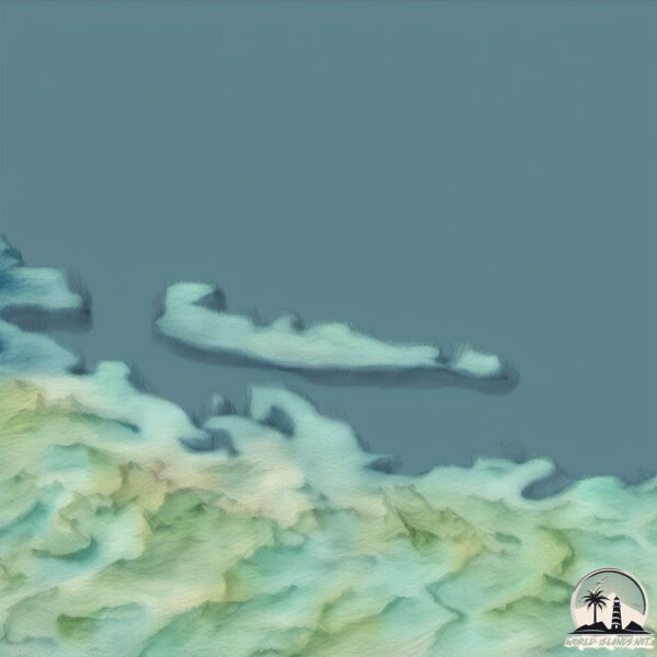
Geography and size of Ostrov Bolshoy Oleny
Size: 3.004 km²
Coastline: 15.8 km
Ocean: Arctic Ocean
Sea: Barentsz Sea
Continent: Europe
Ostrov Bolshoy Oleny is a Small Island spanning 3 km² with a coastline of 15.8 km.
Archipel: –
Tectonic Plate: Eurasia – One of the world’s largest tectonic plates, the Eurasian Plate covers a significant portion of Europe and Asia. It’s characterized by diverse geological features, including the Ural Mountains, the European Plain, and the Himalayas formed from its collision with the Indian Plate.
The geographic heart of the island is pinpointed at these coordinates:
Latitude: 69.06662683 / Longitude: 36.37071084
Climate and weather of Ostrov Bolshoy Oleny
Climate Zone: Continental
Climate Details: Subarctic Climate
Temperature: Cold Summer
Climate Characteristics: Characterized by long, extremely cold winters and short, cool summers, often found in northern latitudes of North America and Eurasia.
Topography and nature of Ostrov Bolshoy Oleny
Timezone: UTC+04:00
Timezone places: Europe/Moscow
Max. Elevation: 51 m
Mean Elevation: 37 m
Vegetation: Open Woodland
Tree Coverage: 84%
The mean elevation is 37 m. The highest elevation on the island reaches approximately 51 meters above sea level. The island is characterized by Plains: Flat, low-lying lands characterized by a maximum elevation of up to 200 meters. On islands, plains are typically coastal lowlands or central flat areas.
Dominating Vegetation: Open Woodland
Characterized by sparsely distributed trees with open canopy allowing sunlight to penetrate, supporting grasses and shrubs underneath. Often found in drier or transitional environments. Ostrov Bolshoy Oleny has a tree cover of 84 %.
Vegetation: 4 vegetation zones – Diverse Island
Four distinct vegetation zones mark these islands as ecologically diverse. They might feature varied landscapes such as forests, beaches, grasslands, and rocky areas. Such diversity reflects the island’s complex ecological interactions and varied habitats, which can support a rich array of wildlife and plant species.
Infrastructure and Travelling to Ostrov Bolshoy Oleny
Does the island have a public airport? no.
There is no public and scheduled airport on Ostrov Bolshoy Oleny. The nearest airport is Murmansk Airport, located 399 km away.
Does the island have a major port? no.
There are no major ports on Ostrov Bolshoy Oleny. The closest major port is BOLSHAYA PIRYU GUBA, approximately 345 km away.
The mean population of Ostrov Bolshoy Oleny is 1 per km². Ostrov Bolshoy Oleny is Gently Populated. The island belongs to Russia.
Continuing your journey, Kildin is the next notable island, situated merely km away.
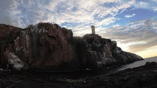
Скала Большой Олений остров маяк.Баренцево море yi4k+

Russia is classified as Emerging region: BRIC: Brazil, Russia, India, and China – Economies noted for their rapid growth and increasing influence on global affairs. The level of income is Upper middle income.
News – Latest Updates and Headlines from Ostrov Bolshoy Oleny
Stay informed with the most recent news and important headlines from Ostrov Bolshoy Oleny. Here’s a roundup of the latest developments.
Please note: The data used here has been primarily extracted from satellite readings. Deviations from exact values may occur, particularly regarding the height of elevations and population density. Land area and coastline measurements refer to average values at mean high tide.