Ostrov Bol’shoy Pelis
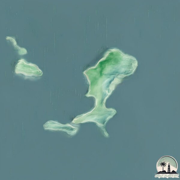
Welcome to Ostrov Bol’shoy Pelis, a Continental island in the Japan Sea, part of the majestic Pacific Ocean. This guide offers a comprehensive overview of what makes Ostrov Bol’shoy Pelis unique – from its geography and climate to its population, infrastructure, and beyond. Dive into the details:
- Geography and Size: Explore the island’s size and location.
- Climate and Weather: Weather patterns and temperature.
- Topography and Nature: Uncover the natural wonders of the island.
- Infrastructure and Travelling: Insights on reaching, staying, and making the most of your visit.
- News and Headlines: Latest News.
Geography and size of Ostrov Bol’shoy Pelis
Size: 3.348 km²
Coastline: 14.4 km
Ocean: Pacific Ocean
Sea: Japan Sea
Continent: Asia
Ostrov Bol’shoy Pelis is a Small Island spanning 3.3 km² with a coastline of 14.4 km.
Archipel: –
Tectonic Plate: Amur – A minor tectonic plate in the region of the Amur River at the border of Russia and China, involved in complex interactions with the Pacific and Eurasian plates.
The geographic heart of the island is pinpointed at these coordinates:
Latitude: 42.65972971 / Longitude: 131.46051741
Climate and weather of Ostrov Bol’shoy Pelis
Climate Zone: Continental
Climate Details: Monsoon-Influenced Warm-Summer Humid Continental Climate
Temperature: Warm Summer
Climate Characteristics: Features warm summers with monsoonal rain and dry, cold winters, characteristic of parts of east Asia.
Topography and nature of Ostrov Bol’shoy Pelis
Timezone: UTC+11:00
Timezone places: Asia/Vladivostok
Max. Elevation: 92 m
Mean Elevation: 55 m
Vegetation: Mixed Forest
Tree Coverage: 67%
The mean elevation is 55 m. The highest elevation on the island reaches approximately 92 meters above sea level. The island is characterized by Plains: Flat, low-lying lands characterized by a maximum elevation of up to 200 meters. On islands, plains are typically coastal lowlands or central flat areas.
Dominating Vegetation: Mixed Forest
A combination of both deciduous and evergreen trees, often found in transitional zones between forest types. These forests offer a diverse habitat for various wildlife species. Ostrov Bol’shoy Pelis has a tree cover of 67 %.
Vegetation: 5 vegetation zones – Highly Diverse Island
With five different vegetation zones, these islands offer a rich tapestry of ecosystems. The variety could include dense forests, open meadows, wetlands, coastal zones, and more. This level of diversity supports an intricate web of life, with each zone playing a vital role in the overall ecological health and balance of the island.
Infrastructure and Travelling to Ostrov Bol’shoy Pelis
Does the island have a public airport? no.
There is no public and scheduled airport on Ostrov Bol’shoy Pelis. The nearest airport is Vladivostok International Airport, located 110 km away.
Does the island have a major port? no.
There are no major ports on Ostrov Bol’shoy Pelis. The closest major port is SLAVYANKA, approximately 23 km away.
The mean population of Ostrov Bol’shoy Pelis is 8 per km². Ostrov Bol’shoy Pelis is Gently Populated. The island belongs to Russia.
Continuing your journey, Ostrov Popova is the next notable island, situated merely km away.
Большой Пелис, остров Матвеева


Russia is classified as Emerging region: BRIC: Brazil, Russia, India, and China – Economies noted for their rapid growth and increasing influence on global affairs. The level of income is Upper middle income.
News – Latest Updates and Headlines from Ostrov Bol’shoy Pelis
Stay informed with the most recent news and important headlines from Ostrov Bol’shoy Pelis. Here’s a roundup of the latest developments.
Please note: The data used here has been primarily extracted from satellite readings. Deviations from exact values may occur, particularly regarding the height of elevations and population density. Land area and coastline measurements refer to average values at mean high tide.