Ostrov Ketoy
Welcome to Ostrov Ketoy, a Polar island in the Sea of Okhotsk, part of the majestic Pacific Ocean. This guide offers a comprehensive overview of what makes Ostrov Ketoy unique – from its geography and climate to its population, infrastructure, and beyond. Dive into the details:
- Geography and Size: Explore the island’s size and location.
- Climate and Weather: Weather patterns and temperature.
- Topography and Nature: Uncover the natural wonders of the island.
- Infrastructure and Travelling: Insights on reaching, staying, and making the most of your visit.
- News and Headlines: Latest News.
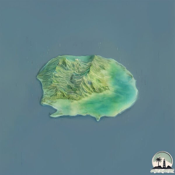
Geography and size of Ostrov Ketoy
Size: 71.9 km²
Coastline: 44.2 km
Ocean: Pacific Ocean
Sea: Sea of Okhotsk
Continent: Asia
Ostrov Ketoy is a Medium Island spanning 72 km² with a coastline of 44 km.
Archipel: Kuril Islands – A volcanic archipelago stretching from Japan to Russia, known for their rugged landscapes and abundant marine life.
Tectonic Plate: Eurasia – One of the world’s largest tectonic plates, the Eurasian Plate covers a significant portion of Europe and Asia. It’s characterized by diverse geological features, including the Ural Mountains, the European Plain, and the Himalayas formed from its collision with the Indian Plate.
The geographic heart of the island is pinpointed at these coordinates:
Latitude: 47.3367841 / Longitude: 152.47804655
Climate and weather of Ostrov Ketoy
Climate Zone: Polar
Climate Details: Tundra
Temperature: Cold
Climate Characteristics: The tundra climate features long, extremely cold winters and short, cool summers. Vegetation is limited to mosses, lichens, and small shrubs due to the low temperatures and short growing seasons. Biodiversity is low, but some specialized species thrive.
Topography and nature of Ostrov Ketoy
Timezone: UTC+11:00
Timezone places: Asia/Vladivostok
Max. Elevation: 970 m
Mean Elevation: 368 m
Vegetation: Open Woodland
Tree Coverage: 37%
The mean elevation is 368 m. The highest elevation on the island reaches approximately 970 meters above sea level. The island is characterized by Mountains: High, steeply elevated landforms. Characterized by both a high maximum elevation (over 500 meters) and a high mean elevation, creating rugged, mountainous terrains on islands.
Dominating Vegetation: Open Woodland
Characterized by sparsely distributed trees with open canopy allowing sunlight to penetrate, supporting grasses and shrubs underneath. Often found in drier or transitional environments. Ostrov Ketoy has a tree cover of 37 %.
Vegetation: 11 vegetation zones – Exceptionally Diverse Island
Islands with more than ten vegetation zones are among the most ecologically rich and varied in the world. These islands are akin to miniature continents, boasting an incredible array of ecosystems. The sheer range of habitats, from high peaks to deep valleys, rainforests to deserts, creates a mosaic of life that is unparalleled. They are crucial for conservation and ecological studies.
Infrastructure and Travelling to Ostrov Ketoy
Does the island have a public airport? no.
There is no public and scheduled airport on Ostrov Ketoy. The nearest airport is Iturup Airport, located 546 km away.
Does the island have a major port? no.
There are no major ports on Ostrov Ketoy. The closest major port is SHAKOTAN, approximately 729 km away.
The mean population of Ostrov Ketoy is 1 per km². Ostrov Ketoy is Uninhabited. The island belongs to Russia.
Continuing your journey, Simushir is the next notable island, situated merely km away.
Остров Кетой, лежбище сивучей (2024.07.20)


Russia is classified as Emerging region: BRIC: Brazil, Russia, India, and China – Economies noted for their rapid growth and increasing influence on global affairs. The level of income is Upper middle income.
News – Latest Updates and Headlines from Ostrov Ketoy
Stay informed with the most recent news and important headlines from Ostrov Ketoy. Here’s a roundup of the latest developments.
Please note: The data used here has been primarily extracted from satellite readings. Deviations from exact values may occur, particularly regarding the height of elevations and population density. Land area and coastline measurements refer to average values at mean high tide.