Ostrov Sakharnaya Golova
Welcome to Ostrov Sakharnaya Golova, a Continental island in the Sea of Okhotsk, part of the majestic Pacific Ocean. This guide offers a comprehensive overview of what makes Ostrov Sakharnaya Golova unique – from its geography and climate to its population, infrastructure, and beyond. Dive into the details:
- Geography and Size: Explore the island’s size and location.
- Climate and Weather: Weather patterns and temperature.
- Topography and Nature: Uncover the natural wonders of the island.
- Infrastructure and Travelling: Insights on reaching, staying, and making the most of your visit.
- News and Headlines: Latest News.
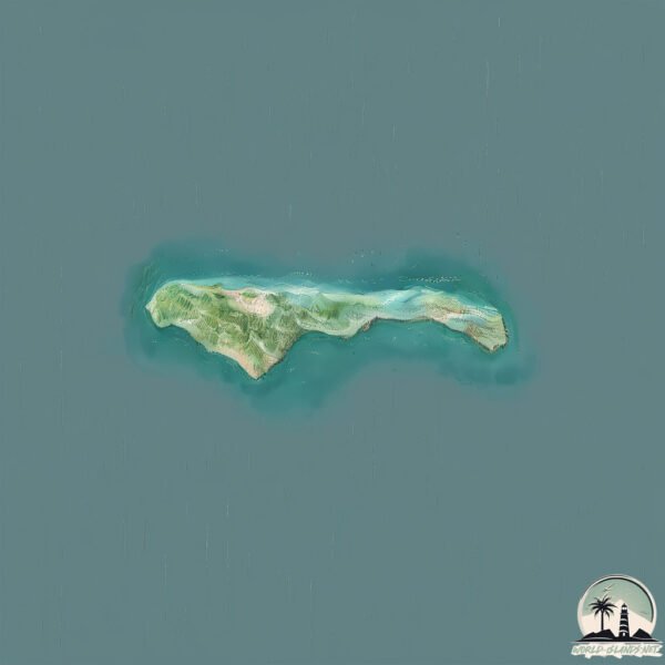
Geography and size of Ostrov Sakharnaya Golova
Size: 3.189 km²
Coastline: 17.5 km
Ocean: Pacific Ocean
Sea: Sea of Okhotsk
Continent: Asia
Ostrov Sakharnaya Golova is a Small Island spanning 3.2 km² with a coastline of 17.5 km.
Archipel: –
Tectonic Plate: Okhotsk – Located in the northwest Pacific Ocean, the Okhotsk Plate encompasses the Sea of Okhotsk, the Kamchatka Peninsula, and parts of Japan. It’s involved in complex interactions with the Pacific and North American plates, contributing to seismic activity in the region.
The geographic heart of the island is pinpointed at these coordinates:
Latitude: 54.9540619 / Longitude: 136.52832648
Climate and weather of Ostrov Sakharnaya Golova
Climate Zone: Continental
Climate Details: Subarctic Climate
Temperature: Cold Summer
Climate Characteristics: Characterized by long, extremely cold winters and short, cool summers, often found in northern latitudes of North America and Eurasia.
Topography and nature of Ostrov Sakharnaya Golova
Timezone: UTC+11:00
Timezone places: Asia/Vladivostok
Max. Elevation: 207 m
Mean Elevation: 111 m
Vegetation: Open Woodland
Tree Coverage: 58%
The mean elevation is 111 m. The highest elevation on the island reaches approximately 207 meters above sea level. The island is characterized by Hills: Gently sloping landforms with rounded tops, having a maximum elevation between 200 and 500 meters. Hills contribute to a varied landscape on islands.
Dominating Vegetation: Open Woodland
Characterized by sparsely distributed trees with open canopy allowing sunlight to penetrate, supporting grasses and shrubs underneath. Often found in drier or transitional environments. Ostrov Sakharnaya Golova has a tree cover of 58 %.
Vegetation: 4 vegetation zones – Diverse Island
Four distinct vegetation zones mark these islands as ecologically diverse. They might feature varied landscapes such as forests, beaches, grasslands, and rocky areas. Such diversity reflects the island’s complex ecological interactions and varied habitats, which can support a rich array of wildlife and plant species.
Infrastructure and Travelling to Ostrov Sakharnaya Golova
Does the island have a public airport? no.
There is no public and scheduled airport on Ostrov Sakharnaya Golova. The nearest airport is Udskoye Airport, located 236 km away.
Does the island have a major port? no.
There are no major ports on Ostrov Sakharnaya Golova. The closest major port is NIKOLAYEVSK NA AMUR, approximately 505 km away.
The mean population of Ostrov Sakharnaya Golova is 0 per km². Ostrov Sakharnaya Golova is Uninhabited. The island belongs to Russia.
Continuing your journey, Ostrov Medvezhiy is the next notable island, situated merely km away.
Russia is classified as Emerging region: BRIC: Brazil, Russia, India, and China – Economies noted for their rapid growth and increasing influence on global affairs. The level of income is Upper middle income.
News – Latest Updates and Headlines from Ostrov Sakharnaya Golova
Stay informed with the most recent news and important headlines from Ostrov Sakharnaya Golova. Here’s a roundup of the latest developments.
Please note: The data used here has been primarily extracted from satellite readings. Deviations from exact values may occur, particularly regarding the height of elevations and population density. Land area and coastline measurements refer to average values at mean high tide.