Welcome to Ostrov Taynyy, a Polar island in the Barentsz Sea, part of the majestic Arctic Ocean. This guide offers a comprehensive overview of what makes Ostrov Taynyy unique – from its geography and climate to its population, infrastructure, and beyond. Dive into the details:
Geography and size of Ostrov Taynyy
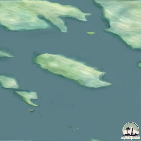
Size: 4.344 km²
Coastline: 13.7 km
Ocean: Arctic Ocean
Sea: Barentsz Sea
Continent: Europe
Ostrov Taynyy is a Small Island spanning 4.3 km² with a coastline of 13.7 km.
Archipel: Novaya Zemlya – A remote and rugged archipelago in the Arctic Ocean of northern Russia, known for its severe climate and important role in Russian Arctic exploration.
Tectonic Plate: Eurasia – One of the world’s largest tectonic plates, the Eurasian Plate covers a significant portion of Europe and Asia. It’s characterized by diverse geological features, including the Ural Mountains, the European Plain, and the Himalayas formed from its collision with the Indian Plate.
The geographic heart of the island is pinpointed at these coordinates:
Latitude: 71.38784624 / Longitude: 53.08607373
Climate and weather of Ostrov Taynyy
Climate Zone: Polar
Climate Details: Tundra
Temperature: Cold
Climate Characteristics: The tundra climate features long, extremely cold winters and short, cool summers. Vegetation is limited to mosses, lichens, and small shrubs due to the low temperatures and short growing seasons. Biodiversity is low, but some specialized species thrive.
Topography and nature of Ostrov Taynyy
Timezone: UTC+04:00
Timezone places: Europe/Moscow
Max. Elevation: 45 m
Mean Elevation: 27 m
Vegetation: Sparse Vegetation
Tree Coverage: 12%
The mean elevation is 27 m. The highest elevation on the island reaches approximately 45 meters above sea level. The island is characterized by Plains: Flat, low-lying lands characterized by a maximum elevation of up to 200 meters. On islands, plains are typically coastal lowlands or central flat areas.
Dominating Vegetation: Sparse Vegetation
These regions have limited plant growth, typically due to extreme conditions like aridity or poor soils. Vegetation is scattered and consists of hardy plant species. Ostrov Taynyy has a tree cover of 12 %.
Vegetation: 2 vegetation zones – Low Diversity Island
Islands with two distinct vegetation zones offer slightly more ecological variety. These zones could be due to differences in elevation, moisture, or other environmental factors. While still limited in biodiversity, these islands may offer a contrast between the two zones, such as a coastline with mangroves and an inland area with grassland.
Infrastructure and Travelling to Ostrov Taynyy
Does the island have a public airport? no.
There is no public and scheduled airport on Ostrov Taynyy. The nearest airport is Naryan Mar Airport, located 415 km away.
Does the island have a major port? no.
There are no major ports on Ostrov Taynyy. The closest major port is MEZEN, approximately 1163 km away.
The mean population of Ostrov Taynyy is 0 per km². Ostrov Taynyy is Uninhabited. The island belongs to Russia.
Continuing your journey, Ostov Sobachiy is the next notable island, situated merely km away.
Список Эпштейна: главная тайна элиты США. Его не существует? | Трамп, остров, ФБР и Маск
Легальная иммиграция в США вместе с Migrator. Гарантия результата в договоре. Узнать свои шансы на визу бесплатно ...Список Эпштейна: главная тайна элиты США. Его не существует? | Трамп, остров, ФБР и Маск
Легальная иммиграция в США вместе с Migrator. Гарантия результата в ...
Легальная иммиграция в США вместе с Migrator. Гарантия результата в договоре. Узнать свои шансы на визу бесплатно ...
Таинственный остров / Mysterious Island (1941) фильм смотреть онлайн
В 1865 году из цитадели рабовладельческого Юга Америки города Ричмонда ...
В 1865 году из цитадели рабовладельческого Юга Америки города Ричмонда на воздушном шаре спасается группа ...
ЗАХВАТЫВАЮЩИЙ ФИЛЬМ ПРИКЛЮЧЕНИЕ ПРО ПОТЕРЯННЫЙ ОСТРОВ СОКРОВИЩ | НАСТОЯЩЕЕ КИНО НЕ ДАЁТ ОТОРВАТЬСЯ
ЗАХВАТЫВАЮЩИЙ ФИЛЬМ ПРИКЛЮЧЕНИЕ ПРО ПОТЕРЯННЫЙ ОСТРОВ СОКРОВИЩ | ...
ЗАХВАТЫВАЮЩИЙ ФИЛЬМ ПРИКЛЮЧЕНИЕ ПРО ПОТЕРЯННЫЙ ОСТРОВ СОКРОВИЩ | НАСТОЯЩЕЕ КИНО НЕ ДАЁТ ...
Тайна Далёкого Острова #советский мультфильм 1958 года #ностальгия #детство #индонезия #приключения
К заметке по геостратегии об Индонезии «Тайна далекого острова» — ...
К заметке по геостратегии об Индонезии «Тайна далекого острова» — советский рисованный мультипликационный ...
ТАЙНА ЗАТЕРЯННОЙ ДЕРЕВНИ | ОСТРОВ ОБРЕЧЕННЫХ | НОВЫЙ ДЕТЕКТИВ 2025
Погрузитесь в захватывающий мир расследований с новым русским ...
Погрузитесь в захватывающий мир расследований с новым русским детективом 2025 года! 🕵️♂️ Тайна затерянной ...
Самые Странные Острова
Есть острова с такими поразительными особенностями, что даже самые ...
Есть острова с такими поразительными особенностями, что даже самые опытные путешественники удивляются им.
Остров чудовищ (1979) — редкий фильм ужасов с элементами фантастики | Island of the Fishmen 4К
Добро пожаловать в мир мистики, ужаса и скрытых экспериментов. «Остров ...
Добро пожаловать в мир мистики, ужаса и скрытых экспериментов. «Остров чудовищ» (1979) — это редкий ...
1999 - Treasure Island - Starring Jack Palance - Inspired by the R. L. Stevenson story
X marks the spot for treachery and adventure in this high-seas hunt ...
X marks the spot for treachery and adventure in this high-seas hunt for hidden gold! Young Jim Hawkins discovers a map to ...
Зачем Эпштейн возил звёзд и политиков на тайный остров
Трамп #ДональдТрамп #Америка #США #выборывСША #президентСША #выборыСША ...
Трамп #ДональдТрамп #Америка #США #выборывСША #президентСША #выборыСША #история #Эпштейн ...
Таинственный остров, где исчезают люди
Таинственный остров, Часть 1 [HD]
Возраст: 12+ Жанр: Приключения, фантастика Год выпуска: 2005 ...
Возраст: 12+ Жанр: Приключения, фантастика Год выпуска: 2005 Продолжительность: ~1 час 20 мин. 1863 год, разгар ...
Самый опасный остров змей
ОСТРОВ ДЕНЕГ И ПРОБЛЕМ! Тайна затерянных сокровищ.
Подписывайтесь на наш канал, здесь много интересных фильмов: ...
Подписывайтесь на наш канал, здесь много интересных фильмов: ...
Таинственный остров. Фильм.
Преуспевающий бизнесмен Максим со спокойной душой отпускает свою жену ...
Преуспевающий бизнесмен Максим со спокойной душой отпускает свою жену — известную журналистку — в очередную ...
Путешествие 2: Таинственный остров - трейлер (дубляж)
Шон Андерсон вместе с маминым ухажером отправляется на таинственный и ...
Шон Андерсон вместе с маминым ухажером отправляется на таинственный и населенный чудовищами остров на поиски ...
УЛЕТНЫЙ ФИЛЬМ ПРИКЛЮЧЕНИЕ ПРО ТАИНСТВЕННЫЙ ОСТРОВ | КИНО, КОТОРОЕ СМОТРЯТ НА ОДНОМ ДЫХАНИИ
УЛЕТНЫЙ ФИЛЬМ ПРИКЛЮЧЕНИЕ ПРО ТАИНСТВЕННЫЙ ОСТРОВ | КИНО, КОТОРОЕ ...
УЛЕТНЫЙ ФИЛЬМ ПРИКЛЮЧЕНИЕ ПРО ТАИНСТВЕННЫЙ ОСТРОВ | КИНО, КОТОРОЕ СМОТРЯТ НА ОДНОМ ДЫХАНИИ ...
МЛАДЕНЕЦ ИЗ МОРЯ, ИЗМЕНИВШИЙ ЖИЗНЬ ДЕРЕВНИ! МРАЧНЫЙ И ЗАВОРАЖИВАЮЩИЙ ТРИЛЛЕР Остров бессмертных
Остров-призрак Хасима — самое страшное место в Японии
Выиграй путешествие мечты в моем ТГ канале
https://t.me/Stolyaric Хасима — это заброшенный остров-призрак в Японии, ...
Тайны древних цивилизаций: Тайна острова Пасхи. Документальный фильм
Что необычного и загадочного таит в себе этот загадочный остров Пасхи. ...
Что необычного и загадочного таит в себе этот загадочный остров Пасхи. Какие секреты таятся на землях острова пасхи.
Тайна острова Бэк Кап (1958 г. Советский дубляж)
Пираты во главе с графом Артигасом с острова Бэк Кап, хотят получить ...
Пираты во главе с графом Артигасом с острова Бэк Кап, хотят получить страшное оружие которое подчинит весь мир.
ЖЮЛЬ ВЕРН - ТАИНСТВЕННЫЙ ОСТРОВ - ЧАСТЬ 1
ТАЙНЫ ОСТРОВА ЭПШТЕЙНА: РАЗОБЛАЧЕНИЕ ПРИЧАСТНОСТИ ЗНАМЕНИТОСТЕЙ И ФБР
Скидка 10% на любую консультацию от Work5 — ...
Аудиокнига\приключения\любимая книга автора\Остров Тайна\остросюжетная книга\интересная книга#1часть
По качеству этой книги - не суди остальные!!! Вашему вниманию книга ...
По качеству этой книги - не суди остальные!!! Вашему вниманию книга В.Топилина - Остров Тайна.Аннотация прочитана ...
Остров ВСЕ СЕРИИ ПОДРЯД (ВСЕ СЕЗОНЫ 1-2)
Смотрите сериал Остров ВСЕ СЕРИИ ПОДРЯД. 00:00 - 1 сезон 10:05:57 - 2 ...
Смотрите сериал Остров ВСЕ СЕРИИ ПОДРЯД. 00:00 - 1 сезон 10:05:57 - 2 сезон Съемочная группа прибывает на ...
Они заблудились в самом сердце амазонских джунглей | Шикарный фильм Приключение
Они заблудились в самом сердце амазонских джунглей | Шикарный фильм ...
Они заблудились в самом сердце амазонских джунглей | Шикарный фильм Приключение Экспедиция, отправившаяся на ...
Russia is classified as Emerging region: BRIC: Brazil, Russia, India, and China – Economies noted for their rapid growth and increasing influence on global affairs. The level of income is Upper middle income.
News – Latest Updates and Headlines from Ostrov Taynyy
Stay informed with the most recent news and important headlines from Ostrov Taynyy. Here’s a roundup of the latest developments.
Loading...
Please note: The data used here has been primarily extracted from satellite readings. Deviations from exact values may occur, particularly regarding the height of elevations and population density. Land area and coastline measurements refer to average values at mean high tide.


![Таинственный остров, Часть 1 [HD]](https://i.ytimg.com/vi/IbU0wEFBcUM/mqdefault.jpg)