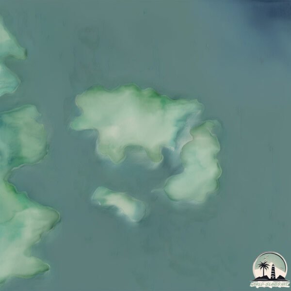
Welcome to Otazo, a Polar island in the South Pacific Ocean, part of the majestic Pacific Ocean. This guide offers a comprehensive overview of what makes Otazo unique – from its geography and climate to its population, infrastructure, and beyond. Dive into the details:
Geography and size of Otazo
Size: 1.204 km²
Coastline: 8.7 km
Ocean: Pacific Ocean
Sea: South Pacific Ocean
Continent: South America
Otazo is a Small Island spanning 1.2 km² with a coastline of 8.7 km.
Archipel: –
Tectonic Plate: Scotia – Situated in the Southern Ocean, surrounding the Scotia Sea, between South America and Antarctica, known for the Scotia Arc and active seismicity.
The geographic heart of the island is pinpointed at these coordinates:
Latitude: -54.23231584 / Longitude: -72.16465363
Climate and weather of Otazo
Climate Zone: Polar
Climate Details: Tundra
Temperature: Cold
Climate Characteristics: The tundra climate features long, extremely cold winters and short, cool summers. Vegetation is limited to mosses, lichens, and small shrubs due to the low temperatures and short growing seasons. Biodiversity is low, but some specialized species thrive.
Topography and nature of Otazo
Timezone: UTC-04:00
Timezone places: America/La_Paz
Max. Elevation: 21 m
Mean Elevation: 18 m
Vegetation: Herbaceous Cover
Tree Coverage: 22%
The mean elevation is 18 m. The highest elevation on the island reaches approximately 21 meters above sea level. The island is characterized by Plains: Flat, low-lying lands characterized by a maximum elevation of up to 200 meters. On islands, plains are typically coastal lowlands or central flat areas.
Dominating Vegetation: Herbaceous Cover
Comprising mainly of grasses, herbs, and ferns, these areas are common in prairies, meadows, and savannas, and can vary widely in species composition. Otazo has a tree cover of 22 %.
Vegetation: 3 vegetation zones – Moderately Diverse Island
These islands start to show a broader range of ecological niches. With three vegetation zones, they may offer a mix of ecosystems like coastal areas, inland woods, and perhaps a distinct wetland or dry area. This diversity supports a wider range of flora and fauna, making these islands more ecologically complex than those with minimal diversity.
Infrastructure and Travelling to Otazo
Does the island have a public airport? no.
There is no public and scheduled airport on Otazo. The nearest airport is President Carlos Ibañez del Campo International Airport, located 199 km away.
Does the island have a major port? no.
There are no major ports on Otazo. The closest major port is PORT SAN JUAN DE LA JUAN, approximately 153 km away.
The mean population of Otazo is 7 per km². Otazo is Gently Populated. The island belongs to Chile.
Continuing your journey, Staines is the next notable island, situated merely km away.
One Man's Mission To Clear Up Florida’s Mangroves | TaiwanPlus News
Reporters: John Van Trieste / Klein Wang Andrew Otazo has spent years trudging through south Florida's mangrove forests, ...One Man's Mission To Clear Up Florida’s Mangroves | TaiwanPlus News
Reporters: John Van Trieste / Klein Wang Andrew Otazo has spent years ...
Reporters: John Van Trieste / Klein Wang Andrew Otazo has spent years trudging through south Florida's mangrove forests, ...
Jewish people in the world
One question that often arises is why Jews around the world maintain a ...
One question that often arises is why Jews around the world maintain a strong financial bond with Israel. Here's a glimpse into the ...
What does a pragmatic 'climate reset' look like? – This Week in Cleantech
This Week in Cleantech is a weekly podcast covering the most impactful ...
This Week in Cleantech is a weekly podcast covering the most impactful stories in clean energy and climate in 15 minutes or less ...
Environmentalist’s kayak stolen during trash cleanup off Key Biscayne
Andrew Otazo used a kayak on Saturday to get to an island off Key ...
Andrew Otazo used a kayak on Saturday to get to an island off Key Biscayne's Crandon Park Marina that needed cleaning.
🇨🇺 Will a new president mean change for Cuba? | Inside Story
Who will succeed the Castros - Fidel and Raul - has been the subject ...
Who will succeed the Castros - Fidel and Raul - has been the subject of intense speculation in Cuba for decades. We now know it ...
NOTA COMPLETA A "MONCHO" OTAZZO REALIZADA POR SEBASTIAN JARUVKIN
PRESENTADO EN EL MARCO DEL ESPACIO "TENGO ALGO PARA CONTARLES" POR ...
PRESENTADO EN EL MARCO DEL ESPACIO "TENGO ALGO PARA CONTARLES" POR CANAL 4 TOTORAS NUESTRA TV ...
We Removed 10,000 Pounds of Trash from the Mangroves!
We spent 85 days removing 10000 of trash from South Florida's coastal ...
We spent 85 days removing 10000 of trash from South Florida's coastal ecosystems! If you would like to assist my cleanup efforts, ...
Meet the guy who's cleaning up a Miami Nature Preserve on piece of trash at a time.
When Andrew Otazo realized that local government wouldn't help and ...
When Andrew Otazo realized that local government wouldn't help and local press wouldn't tell the story, he took it upon himself to ...
Ergotic dj set @マボロシ by mindwarp
Reactions in Havana as Snowden leaves HKong seeking country for asylum
(23 Jun 2013) SHOTLIST AP TELEVISION 1. Wide of Revolution Square with ...
(23 Jun 2013) SHOTLIST AP TELEVISION 1. Wide of Revolution Square with classic cars passing 2. Jose Marti Monument in ...
Cuba Trade Group: The Legal Art of The Cuban Business Deal Now and in the Future.
navegando con el south atlantic - 1º prueba
Estamos probando distintas formas de colocar los cabos.
Estamos probando distintas formas de colocar los cabos.
Proyecto 12 Islas de Intercambio cultural entre Cuba y Chile por medio de colaboración editorial
Editorial Negráfica-Magape Diseño editorial-Black Nymph Art Creada en ...
Editorial Negráfica-Magape Diseño editorial-Black Nymph Art Creada en la ciudad de Los Ángeles el 23 de julio de 2014, ...
New Formula 1 Unveiling
Not the formula 1 car .. couldn't get it on tape, but cray ...
Not the formula 1 car .. couldn't get it on tape, but cray dougnuts/driving by the drivers - Valencia, Spain.
I Removed Half a Ton of Trash from Crandon Park
I spent 12 days removing 1010 pounds of trash from Crandon Park's Bear ...
I spent 12 days removing 1010 pounds of trash from Crandon Park's Bear Cut Preserve mangroves and beach. If you would like to ...
Islas del Delta del Paraná Inferior
santafenosune.
santafenosune.
Popeye The Sailor Organ Grinders Swing Part 2 (1937)
The DVD restoration of this cartoon incorrectly copies credits from ...
The DVD restoration of this cartoon incorrectly copies credits from The Paneless Window Washer, hence the incorrect certificate ...
THE LEADINGS - STILL WORDS
STILL WORDS--- -DIRECCION, REALIZACIÓN Y EDICIÓN POR MANUEL GARCIA DE ...
STILL WORDS--- -DIRECCION, REALIZACIÓN Y EDICIÓN POR MANUEL GARCIA DE OTAZO -MAKE UP: CARMEN LOPEZ ...
Isla del Ciervo (La Manga - Murcia)
Dia de lebeche en la Isla del Ciervo.
Dia de lebeche en la Isla del Ciervo.
I Removed 4 Tons of Trash from the Ocean and Mangroves
I spent 72 days removed 8000 pounds (four tons) of trash from Miami's ...
I spent 72 days removed 8000 pounds (four tons) of trash from Miami's mangroves and ocean. If you would like to assist my ...
Vuelta a la isla de Tenerife, 23/02/2021
Vuelta a la isla de Tenerife, 265 km en bicicleta, realizada el día 23 ...
Vuelta a la isla de Tenerife, 265 km en bicicleta, realizada el día 23 de febrero de 2021. PARTICIPANTES: Daniel Pérez link a la ...
BREAKING 2 High Ranking Members Of Illegal BILLION DOLLAR Business Arrested In State
BREAKING 2 High Ranking Members Of Illegal BILLION DOLLAR Business ...
BREAKING 2 High Ranking Members Of Illegal BILLION DOLLAR Business Arrested In State Two Members of Billion-Dollar ...
Scared Penguin
Penguin in the Valencia trying to jump into the water.
Penguin in the Valencia trying to jump into the water.
Chile is classified as Emerging region: G20: Group of Twenty – Major economies comprising both developed and emerging countries, representing the world’s largest economies. The level of income is Upper middle income.
News – Latest Updates and Headlines from Otazo
Stay informed with the most recent news and important headlines from Otazo. Here’s a roundup of the latest developments.
Loading...
Please note: The data used here has been primarily extracted from satellite readings. Deviations from exact values may occur, particularly regarding the height of elevations and population density. Land area and coastline measurements refer to average values at mean high tide.