Welcome to Otočić Ruda, a Temperate island in the Adriatic Sea, part of the majestic Atlantic Ocean. This guide offers a comprehensive overview of what makes Otočić Ruda unique – from its geography and climate to its population, infrastructure, and beyond. Dive into the details:
Geography and size of Otočić Ruda
Size: 0.328 km²
Coastline: 2.4 km
Ocean: Atlantic Ocean
Sea: Adriatic Sea
Continent: Europe
Otočić Ruda is a Tiny Island spanning 0.328 km² with a coastline of 2.4 km.
Archipel: –
Tectonic Plate: Eurasia – One of the world’s largest tectonic plates, the Eurasian Plate covers a significant portion of Europe and Asia. It’s characterized by diverse geological features, including the Ural Mountains, the European Plain, and the Himalayas formed from its collision with the Indian Plate.
The geographic heart of the island is pinpointed at these coordinates:
Latitude: 42.70779741 / Longitude: 17.92935659
Climate and weather of Otočić Ruda
Climate Zone: Temperate
Climate Details: Hot-Summer Mediterranean Climate
Temperature: Hot Summer
Climate Characteristics: Characterized by hot, dry summers and mild, wet winters, typical of coastal areas with abundant sunshine.
Topography and nature of Otočić Ruda
Timezone: UTC+01:00
Timezone places: Europe/Paris
Max. Elevation: 7 m
Mean Elevation: 5 m
Vegetation: Evergreen Needleleaf Forest
Tree Coverage: 78%
The mean elevation is 5 m. The highest elevation on the island reaches approximately 7 meters above sea level. The island is characterized by Plains: Flat, low-lying lands characterized by a maximum elevation of up to 200 meters. On islands, plains are typically coastal lowlands or central flat areas.
Dominating Vegetation: Evergreen Needleleaf Forest
Dominated by evergreen coniferous trees such as pines and firs, which retain their needle-like leaves throughout the year. These forests are often found in cooler climates. Otočić Ruda has a tree cover of 78 %.
Vegetation: 2 vegetation zones – Low Diversity Island
Islands with two distinct vegetation zones offer slightly more ecological variety. These zones could be due to differences in elevation, moisture, or other environmental factors. While still limited in biodiversity, these islands may offer a contrast between the two zones, such as a coastline with mangroves and an inland area with grassland.
Infrastructure and Travelling to Otočić Ruda
Does the island have a public airport? no.
There is no public and scheduled airport on Otočić Ruda. The nearest airport is Dubrovnik Airport, located 41 km away.
Does the island have a major port? no.
There are no major ports on Otočić Ruda. The closest major port is DUBROVNIK, approximately 17 km away.
The mean population of Otočić Ruda is 231 per km². Otočić Ruda is Moderately Inhabited. The island belongs to Croatia.
Continuing your journey, Otok Šipan is the next notable island, situated merely km away.
🇭🇷 CROATIA: Elafiti Islands Tour from Dubrovnik | TRAVEL VLOG 0170 🇭🇷
Much of Croatia's not-to-be-missed charm and interest lives on its islands, and those nearby the city of Dubrovnik, the Dalmatians, ...🇭🇷 CROATIA: Elafiti Islands Tour from Dubrovnik | TRAVEL VLOG 0170 🇭🇷
Much of Croatia's not-to-be-missed charm and interest lives on its ...
Much of Croatia's not-to-be-missed charm and interest lives on its islands, and those nearby the city of Dubrovnik, the Dalmatians, ...
CROATIA / LOPUD ISLAND / DUBROVNIK / AERIAL VIEW 3 / Fortress Sutvrac
CROATIA / LOPUD ISLAND / DUBROVNIK / AERIAL VIEW 3 / Fortress Sutvrac.
CROATIA / LOPUD ISLAND / DUBROVNIK / AERIAL VIEW 3 / Fortress Sutvrac.
The Elaphiti Islands, Dubrovnik | Boat Trip | Koločep | Šipan | Lopud
In this video the travel turtles take you on a tour around The ...
In this video the travel turtles take you on a tour around The Elaphiti Islands near Dubrovnik. We booked our boat trip through Jet2 ...
Beautiful harbour of Lopud Island - Croatia 🇭🇷
croatia #dubrovnik #sea #summer #shorts.
croatia #dubrovnik #sea #summer #shorts.
LOPUD CROATIA // beach bars and ancient hikes in the elaphiti islands
Come with us to Lopud, one of the most scenic islands in Croatia! ...
Come with us to Lopud, one of the most scenic islands in Croatia! Explore ancient ruins, beach bars, and even an ocean ...
Some of the scenery on Kolocep Island, Croatia.
This is some of the scenery from Kolocep Island which is off of the ...
This is some of the scenery from Kolocep Island which is off of the Croatian coast near Dubrovnik. Please follow me on Facebook ...
Lopud, Croatia Walking Tour ☀️ Elaphiti Islands 4K Walk With Captions
Another fantastic walking tour on one of the most beautiful islands in ...
Another fantastic walking tour on one of the most beautiful islands in the Adriatic Sea called Lopud, which also belongs to the ...
Island of Šipan / Šipanska Luka / Dubrovnik Croatia
A gentle relaxing walk along the coast of the Island of Šipan / ...
A gentle relaxing walk along the coast of the Island of Šipan / Šipanska Luka.
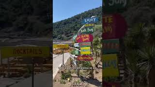
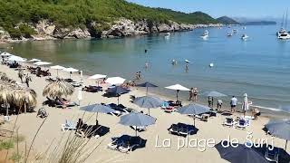
Sunj Beach - sandy beach of Lopud Island - Croatia
dubrovnik #croatia #summer #beach #beachlife #sea #beachvibes #shorts.
dubrovnik #croatia #summer #beach #beachlife #sea #beachvibes #shorts.
Island Lokrum near Dubrovnik, Croatia
Island Lokrum is located in South Dalmatia in Croatia. See beaches in ...
Island Lokrum is located in South Dalmatia in Croatia. See beaches in Otok Lokrum and other tourist attractions and landmarks.
Pirate Ship Galleon to the most beautiful Lopud island from Dubrovnik Croatia
Pirate Ship Galleon to the most beautiful Lopud island from Dubrovnik ...
Pirate Ship Galleon to the most beautiful Lopud island from Dubrovnik Croatia CROATIA EPISODE SERIES DON'T MISS ...
Suđurađ, Šipan Island, Croatia - Drone view in 4K
Produced by Amali Doare 2018, All rights reserved ...
We took a ferry from Dubrovnik to Lopud Island’s Šunj Beach
Dubrovnik is full of beautiful beaches. But, if you are looking for a ...
Dubrovnik is full of beautiful beaches. But, if you are looking for a sandy beach instead of a rocky one, try the island of Lopud.
Lopud island 🇭🇷 #croatiatourism #visitcroatia #croatianshorts #europetravel #traveling #travelvlog
Lopud Island Guide 2021 - 7 Things to Do - Croatian Islands Hop Series E1
This Lopud Island Travel Guide will show you why Lopud is THE BEST ...
This Lopud Island Travel Guide will show you why Lopud is THE BEST ELAPHITI ISLAND (ELAFITI ISLAND) in 2021, and ever!
Sunj Beach - Lopud Island, Croatia
dubrovnik #croatia #summer #beachvibes #beach #beachlife #shorts #sea.
dubrovnik #croatia #summer #beachvibes #beach #beachlife #shorts #sea.
OUR WEEKEND IN DUBROVNIK: Exploring Lopud Island and the Red History Museum
Croatia curious? Or have you been considering the digital nomad ...
Croatia curious? Or have you been considering the digital nomad lifestyle? Either way, you've come to the right ...
5K City Walk, Lopud Island, Croatia 2022
Lopud is a small island off the coast of Dalmatia, southern Croatia. ...
Lopud is a small island off the coast of Dalmatia, southern Croatia. Lopud is economically the most developed of the Elaphiti ...
Lopud Island and Sunj sandy beach near Dubrovnik - L'île de Lopud et la plage de sable de Šunj
Departing from Dubrovnik, discover the island of Lopud, the most ...
Departing from Dubrovnik, discover the island of Lopud, the most interesting of the Elaphiti islands! Explore the island on foot or ...
Lopud island, Dubrovnik. 🇭🇷 #lopudisland #dubrovnik #croatia #famousbeach #croatiabeaches
Lopud - Aerial Video
Lopud island - A REAL PARADISE IN THE ADRIATIC SEA Lopud island is one ...
Lopud island - A REAL PARADISE IN THE ADRIATIC SEA Lopud island is one of the southern Adriatic group of islands and is ...
Dubrovnik,Ferry Boat to Šipan,Elaphiti Island,Croatia
Dubrovnik (Croatian: [dǔbroːʋniːk];historically Ragusa) is a city on ...
Dubrovnik (Croatian: [dǔbroːʋniːk];historically Ragusa) is a city on the Adriatic Sea in southern Croatia. It is one of the most ...
#Lopud,#Croatia #beach #ocean #shorts #short #travel
Island Escapades: Unveiling the Treasures of Lopud, Croatia! ✨ ...
Island Escapades: Unveiling the Treasures of Lopud, Croatia! ✨ Location: Lopud, Croatia Step into a world of wonder as ...
Visit Lopud - Dubrovnik Riviera
The island in the middle, the most developed of its Elaphiti brothers ...
The island in the middle, the most developed of its Elaphiti brothers and the one with the sandy beaches. Sail into or walk through ...
LOPUD ISLAND / DUBROVNIK / ONE OF THE MOST AMAZING DESTINATIONS FOR A BOAT TRIP AROUND DUBROVNIK.
LOPUD ISLAND / DUBROVNIK / CROATIA / ONE OF THE MOST AMAZING ...
LOPUD ISLAND / DUBROVNIK / CROATIA / ONE OF THE MOST AMAZING DESTINATIONS FOR A BOAT TRIP AROUND ...
Croatia is classified as Developed region: nonG7: Developed economies outside of the Group of Seven, characterized by high income and advanced economic structures. The level of income is High income: nonOECD.
News – Latest Updates and Headlines from Otočić Ruda
Stay informed with the most recent news and important headlines from Otočić Ruda. Here’s a roundup of the latest developments.
Loading...
Please note: The data used here has been primarily extracted from satellite readings. Deviations from exact values may occur, particularly regarding the height of elevations and population density. Land area and coastline measurements refer to average values at mean high tide.