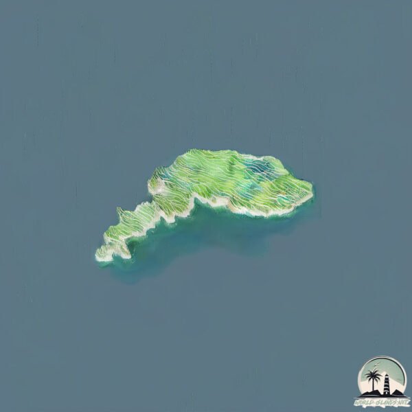
Otok Sušac
Welcome to Otok Sušac, a Temperate island in the Adriatic Sea, part of the majestic Atlantic Ocean. This guide offers a comprehensive overview of what makes Otok Sušac unique – from its geography and climate to its population, infrastructure, and beyond. Dive into the details:
- Geography and Size: Explore the island’s size and location.
- Climate and Weather: Weather patterns and temperature.
- Topography and Nature: Uncover the natural wonders of the island.
- Infrastructure and Travelling: Insights on reaching, staying, and making the most of your visit.
- News and Headlines: Latest News.
Geography and size of Otok Sušac
Size: 4.247 km²
Coastline: 13.7 km
Ocean: Atlantic Ocean
Sea: Adriatic Sea
Continent: Europe
Otok Sušac is a Small Island spanning 4.2 km² with a coastline of 13.7 km.
Archipel: –
Tectonic Plate: Eurasia – One of the world’s largest tectonic plates, the Eurasian Plate covers a significant portion of Europe and Asia. It’s characterized by diverse geological features, including the Ural Mountains, the European Plain, and the Himalayas formed from its collision with the Indian Plate.
The geographic heart of the island is pinpointed at these coordinates:
Latitude: 42.76399155 / Longitude: 16.51308893
Climate and weather of Otok Sušac
Climate Zone: Temperate
Climate Details: Hot-Summer Mediterranean Climate
Temperature: Hot Summer
Climate Characteristics: Characterized by hot, dry summers and mild, wet winters, typical of coastal areas with abundant sunshine.
Topography and nature of Otok Sušac
Timezone: UTC+01:00
Timezone places: Europe/Paris
Max. Elevation: 117 m
Mean Elevation: 75 m
Vegetation: Evergreen Needleleaf Forest
Tree Coverage: 66%
The mean elevation is 75 m. The highest elevation on the island reaches approximately 117 meters above sea level. The island is characterized by Plains: Flat, low-lying lands characterized by a maximum elevation of up to 200 meters. On islands, plains are typically coastal lowlands or central flat areas.
Dominating Vegetation: Evergreen Needleleaf Forest
Dominated by evergreen coniferous trees such as pines and firs, which retain their needle-like leaves throughout the year. These forests are often found in cooler climates. Otok Sušac has a tree cover of 66 %.
Vegetation: 7 vegetation zones – Very Highly Diverse Island
Islands in this range are ecological powerhouses, showcasing a wide array of vegetation zones. Each zone, from lush rainforests to arid scrublands, coastal mangroves to mountainous regions, contributes to a complex and interdependent ecosystem. These islands are often hotspots of biodiversity, supporting numerous species and intricate ecological processes.
Infrastructure and Travelling to Otok Sušac
Does the island have a public airport? no.
There is no public and scheduled airport on Otok Sušac. The nearest airport is Brač Airport, located 60 km away.
Does the island have a major port? no.
There are no major ports on Otok Sušac. The closest major port is KORCULA, approximately 69 km away.
The mean population of Otok Sušac is 13 per km². Otok Sušac is Gently Populated. The island belongs to Croatia.
Continuing your journey, Otok Lastovo is the next notable island, situated merely km away.
Die Leuchtturmwärter von Sušac


Croatia is classified as Developed region: nonG7: Developed economies outside of the Group of Seven, characterized by high income and advanced economic structures. The level of income is High income: nonOECD.
News – Latest Updates and Headlines from Otok Sušac
Stay informed with the most recent news and important headlines from Otok Sušac. Here’s a roundup of the latest developments.
- Weak mag. 2.9 earthquake - Adriatic Sea, 67 km north of Manfredonia, Provincia di Foggia, Apulia, Italy, on Wednesday, Feb 25, 2026, at 03:16 am (GMT +1) - Volcano Discoveryby "Otok Lastovo island" - Google News on 25 February 2026
Weak mag. 2.9 earthquake - Adriatic Sea, 67 km north of Manfredonia, Provincia di Foggia, Apulia, Italy, on Wednesday, Feb 25, 2026, at 03:16 am (GMT +1) Volcano Discovery
- Jeff Bezos Attempted to Book Table at Croatian Tavern, Owner Refused - Total Croatiaby "Otok Lastovo island" - Google News on 18 June 2025
Jeff Bezos Attempted to Book Table at Croatian Tavern, Owner Refused Total Croatia
- ‘Time slows down in Lastovo’: I may just have found Croatia’s most unspoilt archipelago - The Guardianby "Otok Lastovo island" - Google News on 14 May 2025
‘Time slows down in Lastovo’: I may just have found Croatia’s most unspoilt archipelago The Guardian
- The 5 Best Beaches on Dugi Otok, Croatia’s Long Island - Total Croatiaby "Otok Lastovo island" - Google News on 11 July 2024
The 5 Best Beaches on Dugi Otok, Croatia’s Long Island Total Croatia
- Tiny 'exotic paradise' island has Europe's best skies, empty beaches & one hotel - The Sunby "Otok Lastovo island" - Google News on 10 July 2024
Tiny 'exotic paradise' island has Europe's best skies, empty beaches & one hotel The Sun
- Summer on Lastovo – Croatia’s Southernmost Inhabited Island - Total Croatiaby "Otok Lastovo island" - Google News on 5 July 2024
Summer on Lastovo – Croatia’s Southernmost Inhabited Island Total Croatia
- Jeff Bezos, Orlando Bloom and Katy Perry holiday together in Croatia - Time Out Worldwideby "Otok Lastovo island" - Google News on 21 August 2023
Jeff Bezos, Orlando Bloom and Katy Perry holiday together in Croatia Time Out Worldwide
- Sailing in Croatia: Exploring Submarine Tunnels in Dalmatia - Total Croatiaby "Otok Lastovo island" - Google News on 20 April 2023
Sailing in Croatia: Exploring Submarine Tunnels in Dalmatia Total Croatia
- Beyond the crowds in Croatia: five lesser-known spots to discover - National Geographicby "Otok Lastovo island" - Google News on 14 April 2023
Beyond the crowds in Croatia: five lesser-known spots to discover National Geographic
- Where to find Croatia’s secret sailing spots - The Telegraphby "Otok Lastovo island" - Google News on 29 November 2022
Where to find Croatia’s secret sailing spots The Telegraph
Please note: The data used here has been primarily extracted from satellite readings. Deviations from exact values may occur, particularly regarding the height of elevations and population density. Land area and coastline measurements refer to average values at mean high tide.