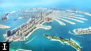
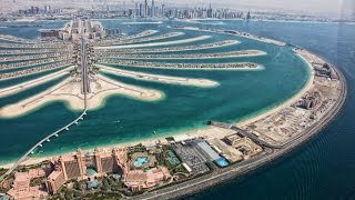
Palm Jumeirah

Welcome to Palm Jumeirah, a Dry island in the Persian Gulf, part of the majestic Indian Ocean. This guide offers a comprehensive overview of what makes Palm Jumeirah unique – from its geography and climate to its population, infrastructure, and beyond. Dive into the details:
- Geography and Size: Explore the island’s size and location.
- Climate and Weather: Weather patterns and temperature.
- Topography and Nature: Uncover the natural wonders of the island.
- Infrastructure and Travelling: Insights on reaching, staying, and making the most of your visit.
- News and Headlines: Latest News.
Geography and size of Palm Jumeirah
Size: 2.107 km²
Coastline: 14.1 km
Ocean: Indian Ocean
Sea: Persian Gulf
Continent: Asia
Palm Jumeirah is a Small Island spanning 2.1 km² with a coastline of 14.1 km.
Archipel: –
Tectonic Plate: Arabia – A major tectonic plate covering the Arabian Peninsula and parts of the Middle East. The plate is primarily continental and known for its collision with the Eurasian Plate, leading to the uplift of the Zagros Mountains.
The geographic heart of the island is pinpointed at these coordinates:
Latitude: 25.1281641 / Longitude: 55.12182717
Climate and weather of Palm Jumeirah
Climate Zone: Dry
Climate Details: Hot Deserts Climate
Temperature: Hot
Climate Characteristics: Dominated by extremely hot temperatures, this climate is marked by minimal rainfall and barren landscapes. Nights often experience drastic temperature drops.
Topography and nature of Palm Jumeirah
Timezone: UTC+04:00
Timezone places: Asia/Dubai
Max. Elevation: -4 m
Mean Elevation: -4 m
Vegetation: Sparse Vegetation
Tree Coverage: 47%
The mean elevation is -4 m. Remarkably, this unique island barely emerges above the sea level, showcasing nature’s fascinating interplay with the ocean. The island is characterized by Plains: Flat, low-lying lands characterized by a maximum elevation of up to 200 meters. On islands, plains are typically coastal lowlands or central flat areas.
Dominating Vegetation: Sparse Vegetation
These regions have limited plant growth, typically due to extreme conditions like aridity or poor soils. Vegetation is scattered and consists of hardy plant species. Palm Jumeirah has a tree cover of 47 %.
Vegetation: 1 vegetation zones – Minimal Diversity Island
These islands exhibit the most basic level of ecological diversity, often characterized by a single dominant vegetation type. This could be due to extreme environmental conditions, limited land area, or significant human impact. They represent unique ecosystems where specific species have adapted to thrive in these singular environments.
Infrastructure and Travelling to Palm Jumeirah
Does the island have a public airport? no.
There is no public and scheduled airport on Palm Jumeirah. The nearest airport is Al Maktoum International Airport, located 24 km away.
Does the island have a major port? no.
There are no major ports on Palm Jumeirah. The closest major port is MINA JABAL ALI, approximately 12 km away.
The mean population of Palm Jumeirah is per km². Palm Jumeirah is . The island belongs to United Arab Emirates.
Continuing your journey, Jazīrat as Sīnīyah is the next notable island, situated merely km away.
Inside Amazing Dubai Palm Island Jumeirah

United Arab Emirates is classified as Developing region: Regions characterized by lower income levels, with economies in the process of industrialization and modernization. The level of income is High income: nonOECD.
News – Latest Updates and Headlines from Palm Jumeirah
Stay informed with the most recent news and important headlines from Palm Jumeirah. Here’s a roundup of the latest developments.
Please note: The data used here has been primarily extracted from satellite readings. Deviations from exact values may occur, particularly regarding the height of elevations and population density. Land area and coastline measurements refer to average values at mean high tide.