Welcome to Parala, a Tropical island in the Bay of Bengal, part of the majestic Indian Ocean. This guide offers a comprehensive overview of what makes Parala unique – from its geography and climate to its population, infrastructure, and beyond. Dive into the details:
Geography and size of Parala
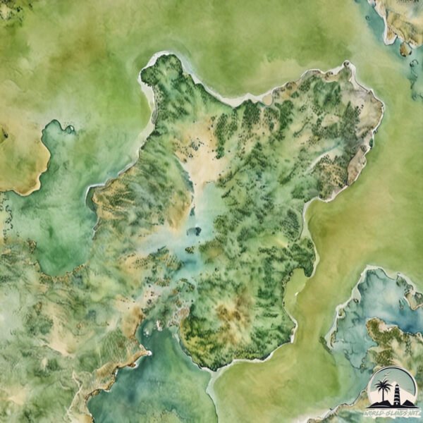
Size: 15.2 km²
Coastline: 22.3 km
Ocean: Indian Ocean
Sea: Bay of Bengal
Continent: Asia
Parala is a Medium Island spanning 15 km² with a coastline of 22 km.
Archipel: –
Tectonic Plate: India – A major tectonic plate that initially moved northward at a rapid pace before colliding with the Eurasian Plate. This collision is responsible for the uplift of the Himalayas and the Tibetan Plateau.
The geographic heart of the island is pinpointed at these coordinates:
Latitude: 19.66404485 / Longitude: 85.39433134
Climate and weather of Parala
Climate Zone: Tropical
Climate Details: Tropical Savanna, Wet
Temperature: Hot
Climate Characteristics: Defined by distinct wet and dry seasons with high temperatures year-round. Pronounced rainfall occurs during the wet season, while the dry season is marked by drought.
Topography and nature of Parala
Timezone: UTC+05:30
Timezone places: Asia/Kolkata
Max. Elevation: 9 m
Mean Elevation: 5 m
Vegetation: Wetland
Tree Coverage: 18%
The mean elevation is 5 m. The highest elevation on the island reaches approximately 9 meters above sea level. The island is characterized by Plains: Flat, low-lying lands characterized by a maximum elevation of up to 200 meters. On islands, plains are typically coastal lowlands or central flat areas.
Dominating Vegetation: Wetland
These areas are saturated with water, either permanently or seasonally, and support aquatic plants. Wetlands are important for biodiversity and water filtration. Parala has a tree cover of 18 %.
Vegetation: 7 vegetation zones – Very Highly Diverse Island
Islands in this range are ecological powerhouses, showcasing a wide array of vegetation zones. Each zone, from lush rainforests to arid scrublands, coastal mangroves to mountainous regions, contributes to a complex and interdependent ecosystem. These islands are often hotspots of biodiversity, supporting numerous species and intricate ecological processes.
Infrastructure and Travelling to Parala
Does the island have a public airport? no.
There is no public and scheduled airport on Parala. The nearest airport is Biju Patnaik Airport, located 77 km away.
Does the island have a major port? no.
There are no major ports on Parala. The closest major port is GOPALPUR, approximately 68 km away.
The mean population of Parala is 193 per km². Parala is Moderately Inhabited. The island belongs to India.
Continuing your journey, Baghamunda is the next notable island, situated merely km away.
South Paracel Islands: China's Hidden Gem Known as God’s Aquarium
The South Paracel Islands, a virgin land in the South China Sea, is a hidden gem of Sansha City, Hainan Province. Known as ...South Paracel Islands: China's Hidden Gem Known as God’s Aquarium
The South Paracel Islands, a virgin land in the South China Sea, is a ...
The South Paracel Islands, a virgin land in the South China Sea, is a hidden gem of Sansha City, Hainan Province. Known as ...
How to get to Paracel Island #travel
Enjoy Follow me for more Subscribe for more ...
Enjoy Follow me for more Subscribe for more ...
Why China’s Man-Made Military Islands Are a Disaster
Explore China's ambitious plan to dominate the South China Sea through ...
Explore China's ambitious plan to dominate the South China Sea through massive artificial islands equipped with military ...
Seychelles Creole Festival: Watch These Ladies Dance Their Hearts Out! #mrpabivlogs
Beautiful street women dance in the Creole Festival in La Digue Island ...
Beautiful street women dance in the Creole Festival in La Digue Island Seychelles 2022. They celebrate after the COVID-19.
Who owns the Paracel Islands?
The Paracel Islands, also known as the Xisha Islands in Chinese and ...
The Paracel Islands, also known as the Xisha Islands in Chinese and the Hoàng Sa Archipelago in Vietnamese, are a disputed ...
Top Must-Visit Places In Paros Greece
Explore the uncharted territories of Paros, Greece, and uncover its ...
Explore the uncharted territories of Paros, Greece, and uncover its best-kept secrets! From secluded beaches to charming villages ...
Cataract - Lens Implant - Medical Arts Shorts - 3d animation surgery
shorts Cataract - Lens Implant - Medical Arts Shorts - 3d animation ...
shorts Cataract - Lens Implant - Medical Arts Shorts - 3d animation surgery Blurry to sharp. Imagine upgrading from standard TV to ...
The Spratly Islands Dispute
The Spratly Islands are situated roughly in the middle of the South ...
The Spratly Islands are situated roughly in the middle of the South China Sea, halfway between the Philippines and Vietnam.
Paracel Islands, Sansha City, Hainan Province
Subscribe #shorts.
Subscribe #shorts.
Pedro Capó, Farruko - Calma (Remix - Official Video)
Disfruten nuestro nuevo video! Pedro Capó & Farruko - Calma REMIX! Qué ...
Disfruten nuestro nuevo video! Pedro Capó & Farruko - Calma REMIX! Qué te pareció? Comenta abajo! Música Disponible: Apple ...
If you want long lashes, use this!!
World’s Only Cruise To The South China Sea | 4-day Journey to The Paracel Islands
Today, I will be taking the World's only cruise to the South China Sea ...
Today, I will be taking the World's only cruise to the South China Sea Room : 6-person Oceanview Cabin Floor : 7 Route : Sanya ...
The Six-Country Fight Over These Tiny, Terrible Islands
Parallel Parking Lesson | parallel parking tutorial: 4 steps
Parallel parking lesson | parallel parking tutorial | parking tutorial ...
Parallel parking lesson | parallel parking tutorial | parking tutorial | Parallel parking in any place is quite challenging for new ...
Paracel Islands #Shorts
do you kown Paracel Islands?
do you kown Paracel Islands?
Paracel Island #fact #knowledge_booster #map #geographyculture #geographynow #history #motivation
I Dropped a Camera to the Bottom of Bali's Black Magic Island
If you want to grab yourself a new underwater action camera from ...
If you want to grab yourself a new underwater action camera from Insta360 (the ones used to film this video), and also support the ...
Untouched. Paradise. Pagan.The last frontier of the Pacific. #pagan #shorts
Pagan Island Adventure About 170 nautical miles north of Saipan lies ...
Pagan Island Adventure About 170 nautical miles north of Saipan lies Pagan Island — home to two volcanoes and untouched ...
For Rent, Hempstead, Long Island. Duplex UnitDisponible Para La Renta. En Hempstead, Long Island.
Actualización De Agosto, 2025 Estan Bajando Los Intereses ...
Actualización De Agosto, 2025 Estan Bajando Los Intereses Hipotecarios? Si, aqui te explico más.
War China Paracel Island Army Base
Explorando Apocalipsis Island de Vicente García - ¿Perfecto para la Spooky Season?
El 5 de Enero de 2010, en plena noche de Reyes, una nueva infección ...
El 5 de Enero de 2010, en plena noche de Reyes, una nueva infección masiva tiene lugar en la cárcel de Palma convirtiendo a ...
The Paracel Islands: A Battle for the South China Sea
The Paracel Islands, a small but strategic group of islands in the ...
The Paracel Islands, a small but strategic group of islands in the South China Sea, have become a major flashpoint in ...
Paracel island #googleearth #map #short #chinasea
china want paracel islands 😭😭//by manish world
India is classified as Emerging region: BRIC: Brazil, Russia, India, and China – Economies noted for their rapid growth and increasing influence on global affairs. The level of income is Lower middle income.
News – Latest Updates and Headlines from Parala
Stay informed with the most recent news and important headlines from Parala. Here’s a roundup of the latest developments.
Loading...
Please note: The data used here has been primarily extracted from satellite readings. Deviations from exact values may occur, particularly regarding the height of elevations and population density. Land area and coastline measurements refer to average values at mean high tide.