Welcome to Paul Island, a Temperate island in the The Coastal Waters of Southeast Alaska and British Columbia, part of the majestic Pacific Ocean. This guide offers a comprehensive overview of what makes Paul Island unique – from its geography and climate to its population, infrastructure, and beyond. Dive into the details:
Geography and size of Paul Island
Size: 0.241 km²
Coastline: 2.3 km
Ocean: Pacific Ocean
Sea: The Coastal Waters of Southeast Alaska and British Columbia
Continent: North America
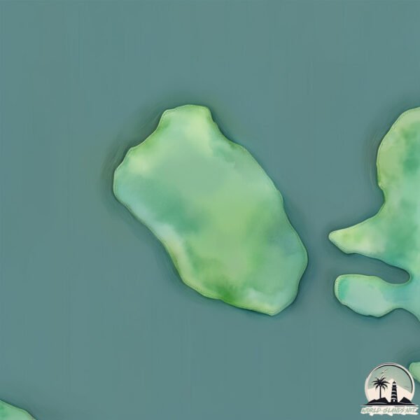
Paul Island is a Tiny Island spanning 0.241 km² with a coastline of 2.3 km.
Archipel: –
Tectonic Plate: North America – Covers North America and parts of the Atlantic and Arctic Oceans, characterized by diverse geological features and varying levels of seismic activity.
The geographic heart of the island is pinpointed at these coordinates:
Latitude: 49.50702541 / Longitude: -124.22004144
Climate and weather of Paul Island
Climate Zone: Temperate
Climate Details: Warm-Summer Mediterranean Climate
Temperature: Warm Summer
Climate Characteristics: Characterized by warm, dry summers and mild, wet winters, typical of coastal areas with abundant sunshine Rain is more common in the winter months, maintaining a moderate climate.
Topography and nature of Paul Island
Timezone: UTC-08:00
Timezone places: America/Los_Angeles
Max. Elevation: 11 m
Mean Elevation: 7 m
Vegetation: Evergreen Needleleaf Forest
Tree Coverage: 73%
The mean elevation is 7 m. The highest elevation on the island reaches approximately 11 meters above sea level. The island is characterized by Plains: Flat, low-lying lands characterized by a maximum elevation of up to 200 meters. On islands, plains are typically coastal lowlands or central flat areas.
Dominating Vegetation: Evergreen Needleleaf Forest
Dominated by evergreen coniferous trees such as pines and firs, which retain their needle-like leaves throughout the year. These forests are often found in cooler climates. Paul Island has a tree cover of 73 %.
Vegetation: 1 vegetation zones – Minimal Diversity Island
These islands exhibit the most basic level of ecological diversity, often characterized by a single dominant vegetation type. This could be due to extreme environmental conditions, limited land area, or significant human impact. They represent unique ecosystems where specific species have adapted to thrive in these singular environments.
Infrastructure and Travelling to Paul Island
Does the island have a public airport? no.
There is no public and scheduled airport on Paul Island. The nearest airport is Texada Gillies Bay Airport, located 39 km away.
Does the island have a major port? no.
There are no major ports on Paul Island. The closest major port is NANOOSE HARBOR, approximately 27 km away.
The mean population of Paul Island is 6 per km². Paul Island is Gently Populated. The island belongs to Canada.
Continuing your journey, Lasqueti is the next notable island, situated merely km away.
True Story of Abandoned on St. Paul Island: The Lobster Factory Tragedy
Abandoned for 10 months on a remote island—this is the true story of betrayal and survival. VIDEOS TO WATCH NEXT: ...True Story of Abandoned on St. Paul Island: The Lobster Factory Tragedy
Abandoned for 10 months on a remote island—this is the true story of ...
Abandoned for 10 months on a remote island—this is the true story of betrayal and survival. VIDEOS TO WATCH NEXT: ...
Stranded at a Lobster Factory and Left to Die…
Seven people were left on this desolate, remote island with little ...
Seven people were left on this desolate, remote island with little food to guard a lobster factory over the winter. They were only ...
The Forgotten Castaway of St. Paul Island
Stranded in the North Atlantic, one man defied nature and fate. ...
Stranded in the North Atlantic, one man defied nature and fate. Discover the gripping survival tale of the St. Paul castaway!
King Eiders in the Harsh Environment of Alaska's St. Paul Island — Browning Films Episode 5
Life is very fragile and you acquire that understanding by being out ...
Life is very fragile and you acquire that understanding by being out there in the elements, especially on St. Paul Island. The harsh ...
Dua Lipa ft. Sean Paul - Island Fever (Official Music Video) | Lyric
A vibrant tropical dance anthem reimagined in a fanmade version ...
A vibrant tropical dance anthem reimagined in a fanmade version created with artificial intelligence, inspired by the smooth pop ...
When Jake Paul Roasted The Island Boys 😂
Logan Alexander Paul is an American social media personality, actor, ...
Logan Alexander Paul is an American social media personality, actor, and professional wrestler. He is currently signed to WWE.
Discovering St. Paul Island: A Hidden Gem in Alaska
Join us as we embark on an unforgettable journey to St. Paul Island, a ...
Join us as we embark on an unforgettable journey to St. Paul Island, a hidden gem nestled in the breathtaking wilderness of ...
Life on Alaska's Most Remote Island (surreal experience) 🇺🇸
Far from the Alaskan mainland is a secluded island in the Bering ...
Far from the Alaskan mainland is a secluded island in the Bering Strait. Here the views span for an eternity, Russia is within sight, ...
Town of St. Paul, Alaska | Remote Alaska
One of the most remote settlements in all of Alaska, the village of ...
One of the most remote settlements in all of Alaska, the village of St. Paul stands alone amid the vast Bering Sea, a place where ...
King Eider Outfitters ST Paul Island Aerial tour
Hunt with Alaska's Premier King Eider Outfitter on St Paul Island, ...
Hunt with Alaska's Premier King Eider Outfitter on St Paul Island, Aleutian Island Waterfowlers full time since 2001.
îld saint paul island in indian ocean #asia #indianocean #ocean #map #googleearth #beach#oceanatlas
I Spent a Week on St Paul Island and Found the MOST UNEXPECTED Gem!
travel #explore #alaska Join me on an unforgettable adventure to St. ...
travel #explore #alaska Join me on an unforgettable adventure to St. Paul Island, Alaska, a remote treasure of the Bering Sea!
Mysteries of St. Paul Island
Explore St. Paul Island's unique landscape, rare flora, and historical ...
Explore St. Paul Island's unique landscape, rare flora, and historical survival techniques used by ocean tribes. Delve into ancient ...
Dark Secrets of the World’s Most Isolated Island
Start your free trial with Shopify at this link! ...
Start your free trial with Shopify at this link!
http://shopify.com/yestheory This week, I traveled to the most remotely inhabited island ...
New Spots to Stay in Cape Breton & Visiting St. Paul Island with Nothern Tip Charters | Nova Scotia
Join us as we explore with Cape Breton Northern Tip Charters on an ...
Join us as we explore with Cape Breton Northern Tip Charters on an exciting adventure to St. Paul Island in Nova Scotia while ...
Amsterdam Island & Island Saint Paul #shorts
Amsterdam Island & Island Saint Paul #shorts Subscribe: ...
St Paul’s Shipwreck- #StPaulsShipwreck #StPaulsIsland #Selmunett #Mellieha #MaltaHistory
MaltaHeritage #StPaulsStory #HistoricalMalta #MaltaLandmarks ...
MaltaHeritage #StPaulsStory #HistoricalMalta #MaltaLandmarks #BiblicalEvents #StPaulsLegacy #MaltaShipwreck ...
St. Paul Island, in 4K
I had the privilege of visiting St. Paul, AK for work recently and ...
I had the privilege of visiting St. Paul, AK for work recently and thought it would be a great place to capture on my drone, being that ...
St. Paul Island store run
This is a basic tutorial on social distancing store run etiquette ...
This is a basic tutorial on social distancing store run etiquette video for community members. Brough to you by the City and Tribal ...
The history of St. Paul, Alaska
St. Paul, Alaska.
St. Paul, Alaska.
Saint Paul, Alaska
CORRECTION: I made an error in the video – the island I mentioned as ...
CORRECTION: I made an error in the video – the island I mentioned as Saint George is actually Otter Island ♀️.
St. Paul Island
A trip to St. Paul Island in the Bering Sea for birding, seal watching ...
A trip to St. Paul Island in the Bering Sea for birding, seal watching and Native cultural experiences.
St Paul Island Part1
Excursion to St Paul Island, Nova Scotia, 2010 organized by Duane ...
Excursion to St Paul Island, Nova Scotia, 2010 organized by Duane Traver. A Duane Traver Video.
Canada is classified as Developed region: G7: Group of Seven – Major advanced economies, including Canada, France, Germany, Italy, Japan, the United Kingdom, and the United States. The level of income is High income: OECD.
News – Latest Updates and Headlines from Paul Island
Stay informed with the most recent news and important headlines from Paul Island. Here’s a roundup of the latest developments.
Loading...
Please note: The data used here has been primarily extracted from satellite readings. Deviations from exact values may occur, particularly regarding the height of elevations and population density. Land area and coastline measurements refer to average values at mean high tide.